Near Hit Severe Thunderstorm of 12 Jun 22
1 year ago
5
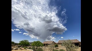
This storm passed overhead just a few minutes earlier and was nothing but disorganized clouds with some virga falling. 15 minutes later, weather satellite revealed explosive convection with +1 inch hail and over 800 in-cloud lightning discharges (within a five minute period) just 20 miles to my east near Burns, Wyoming. Temperatures were in the low 90's with dew points in the mid 30's.
The anvil expanded overhead a few minutes after this image and the storm was no longer visible.
Faceoff by Kevin MacLeod is licensed under a Creative Commons Attribution 4.0 license. https://creativecommons.org/licenses/...
Source: http://incompetech.com/music/royalty-...
Artist: http://incompetech.com/
Loading comments...
-
 6:24
6:24
Weather Sky & Clouds
1 year ago $0.01 earnedPre-Monsoon Weather (mid-May 2023)
35 -
 16:09
16:09
Clownfish TV
12 hours agoMicrosoft DISABLES Windows Recall After MASSIVE Public Backlash!
35.6K52 -
 16:17
16:17
TENET Media
15 hours agoThe Shopping Cart Theory | Matt Christiansen
36.1K32 -
 17:55
17:55
JoBlo Originals
1 day agoWhat Happened to EPIC MEAL TIME?
44.7K4 -
 31:02
31:02
Degenerate Plays
15 hours agoBest Girl Needs Her Swimsuit - Final Fantasy 7: Ever Crisis : Part 2
40.4K3 -
 48:14
48:14
World Nomac
1 day agoMy First Time in Shanghai, China 🇨🇳
49.6K13 -
 2:57:13
SNEAKO
15 hours ago"Who Do You Hate the Most?" - One Minute Podcast
116K118 -
 4:47:25
SonnyFaz
11 hours agoDr. Shiva x Sonny IRL
66.5K22 -
 4:28:03
LumpyPotatoX2
17 hours agoSub-Sunday on Rumble - #RumbleTakeover
74.6K4 -
 26:04
26:04
iamLucid
1 day agoVideo Game Piracy is Unstoppable
98.5K47