The Biggest Secret In America! The Walker Lane Fault Zone!
World News Report Today!
June 4th 2023!
The Biggest Secret In America! The Walker Lane Fault Zone!
The #WalkerLane Walker Lane #walker land (walker lane) #Fault Zone is the best kept secret in #America. Not found on the #usgs web site and not well known by Americans. This fault zone, The Walker Lane Fault Zone is said to be the next West Coast boundary of North America. #News to you and me. We have a large old volcano right near the large swarm of #earthquakes we have seen in #Ridgecrest #California and in #Nevada ! This volcano is know as the Boundary Peak Mountain and is the highest point in #Nevada ! It stands 13,147 feet. It has not been active in a long time until NOW. We also have geological features up and down the fault including the Long Valley Caldera Field and The Hot Creek Geological Site. Why main stream media and our Government has said nothing is more than strange as is the fact that the #USGS does not show this fault line on its fault line map although it is agreed that this will become the new West Coast Boundary.
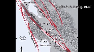
The Walker Lane is a geologic trough roughly aligned with the California/Nevada border southward to where Death Valley intersects the Garlock Fault, a major left lateral, or sinistral, strike-slip fault. The north-northwest end of the Walker Lane is between Pyramid Lake in Nevada and California's Lassen Peak[1][2] where the Honey Lake Fault Zone, the Warm Springs Valley Fault, and the Pyramid Lake Fault Zone[3] meet the transverse tectonic zone forming the southern boundary of the Modoc Plateau and Columbia Plateau provinces. The Walker Lane takes up 15 to 25 percent of the boundary motion between the Pacific Plate and the North American Plate, the other 75 percent being taken up by the San Andreas Fault system to the west.[4][5] The Walker Lane may represent an incipient major transform fault zone which could replace the San Andreas as the plate boundary in the future.[6][3]
The Walker Lane deformation belt accommodates nearly 12 mm/yr of dextral shear between the Sierra Nevada-Great Valley Block and North America.[7][8] The belt is characterized by the northwest-striking trans-current faults and co-evolutionary dip-slip faults formed as result of a spatially segregated displacement field.[9]
Please see the following links for more information...
https://en.wikipedia.org/wiki/Walker_Lane
https://en.wikipedia.org/wiki/Boundary_Peak_(Nevada)
https://volcanohotspot.files.wordpress.com/2018/04/image001.jpg?w=627
Please share and Subscribe and help the channel by purchasing a cup of coffee for WNRT to help us keep pushing to get real news to you!
-
 24:28
24:28
MYSTERIOUSREALITIESNOW
1 year agoDire Earthquake Risk & Infrastructure Vulnerability: The Grim Reality of the San Andreas Fault Line
200 -
 9:30
9:30
4Crawler
1 year ago1838 San Andreas Fault Earthquake, 184th Anniversary
70 -
 11:15
11:15
4Crawler
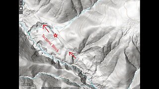
1 year ago $0.01 earnedStevens Canyon Land Slide, Tectonic Block?, Part 2
19 -
 8:48
8:48
4Crawler
1 year agoStevens Creek Main Branch above Waterwheel Creek, Initial Recon
69 -
 13:33
13:33
4Crawler
2 years agoStevens Creek Canyon: Above the Landslide
1 -
 4:13
4:13
4Crawler
9 months agoGold Mine Creek - Tectonic Block
16 -
 4:59
4:59
4Crawler
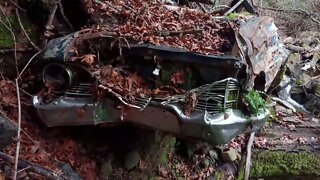
2 years agoStevens Creek Road, Another Wrecked Car and More!
7 -
 2:36
2:36
KGTV
4 years agoTaking a closer look at San Diego's fault lines
14 -
 6:20
6:20
MaryGreeley
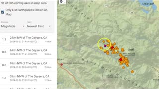
4 months agoLarge Earthquake Swarm The Geysers, Northern California, M 4.2 Maacama Fault Zone
186 -
 21:18
21:18
Whothrewthecurve
7 months agoFissures Opening Across the United States: Causes and Consequences
95