Tropical Storm Cristobal
## Unpredictable Path: Tropical Storm Cristobal's Unprecedented Journey Leaves Trail of Destruction
**2020's Unforgettable Storm**: An Examination of the Anomalous Track of Tropical Storm Cristobal
**Tropical Storm Cristobal** embarked on an extraordinary and unpredictable journey in early June 2020, defying traditional hurricane trajectories and leaving a wake of destruction along its meandering path. Emerging from the remnants of Eastern Pacific Tropical Storm Amanda, Cristobal's atypical development was propelled by a Central American Gyre, an atmospheric phenomenon that spurred its formation in a region infamous for its hurricane-spawning conditions.
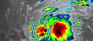
In a rare sequence of events, the Central American Gyre, a vast area of low pressure, coalesced over Central America and the western Caribbean Sea, giving rise to Amanda in the Eastern Pacific. Amanda's impact was catastrophic in El Salvador, causing fatalities and extensive flooding during the last weekend of May.
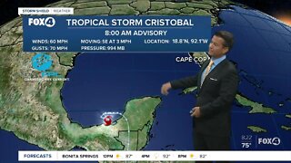
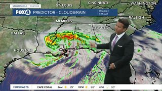
However, Amanda's remnants continued to influence the region's weather dynamics. As Amanda's energy interacted with the atmosphere, it catalyzed the formation of Tropical Depression Three in the southwestern Gulf of Mexico on June 1. The depression rapidly intensified into **Tropical Storm Cristobal** on June 2, marking the earliest-in-season third named Atlantic storm in history.
Cristobal's initial landfall occurred on June 3, west of Ciudad del Carmen, Mexico, where it unleashed heavy rains and gradual weakening. The storm lingered over Mexico's Campeche and Yucatan states, as well as parts of northern Guatemala, inundating eastern Mexico with over 20 inches of rainfall in some regions.
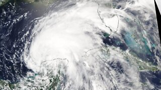
However, it was Cristobal's journey across the Gulf of Mexico that defied expectations and culminated in its subsequent impact on the upper Midwest. The storm regained strength, leading to a historic landfall in southeast Louisiana on June 7, with winds of 50 mph and a pressure of 992 mb.
Cristobal's size led to wide-ranging effects, extending well beyond its center. Heavy rainfall, flash flooding, and storm surge flooding were observed along its path. Notably, flooding occurred in areas as far apart as Jacksonville, Florida, and Waveland, Mississippi, where water levels surged nearly 6 feet above normal.
One of the most peculiar aspects of Cristobal's journey was its unprecedented inland track into the upper Midwest. Tracking into the Midwest is an extraordinary occurrence for tropical cyclones, especially one that had already made landfall along the Gulf Coast. Cristobal continued its trajectory through Iowa and Wisconsin, becoming the fourth Atlantic tropical cyclone remnant to reach Wisconsin in over a century.
The storm left its mark on the Midwest, setting all-time June low-pressure records and unleashing damaging thunderstorm winds that knocked out power and downed trees in Chicagoland and Michigan.
Cristobal's unusual journey underscored the unpredictable nature of tropical cyclones and their potential to defy historical norms. Its meandering path serves as a stark reminder of the complexity of weather patterns and the necessity for continued research to better understand the factors that influence these storms' trajectories.
As the world grapples with the increasing frequency and intensity of extreme weather events, Tropical Storm Cristobal's remarkable journey remains a testament to the power and unpredictability of nature.
-
 0:31
0:31
ybanlewv
1 year agoTropical Storm Cristobal
41.4K -
 1:21
1:21
WFTX
4 years agoTropical Storm Cristobal now over land
14 -
 0:53
0:53
Newsy
4 years agoTropical Storm Cristobal To Make Landfall Along Gulf Coast Sunday
3.28K -
 0:50
0:50
WFTX
4 years agoTropical Storm Cristobal Update 6/3/20 8 AM
439 -
 2:35
2:35
HtownVideo
4 years ago $5.38 earnedTornado begins to form out of Tropical Storm Imelda
12.8K -
 0:36
0:36
KTNV
4 years agoTropical storm Cristobal to hit U.S. Gulf Coast
962 -
 0:51
0:51
ybanlewv
1 year agoTropical Storm Cristobal engine start
41.4K -
 41:19
41:19
MightyMeat
9 months agoHurricane Idalia
129 -
 11:40
11:40
Whothrewthecurve
9 months agoUnraveling the Possibility of a Category 6 Hurricane: Science and Implications
17 -
 1:42
1:42
WFTX
4 years agoTropical Depression Cristobal 5AM
26