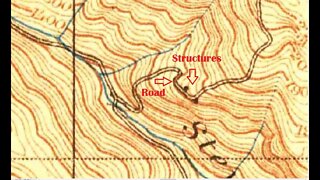
Montebello Ridge Road, 2nd/3rd Visit
Taking another shot at this old road that shows up on the 1895 USGS historical top map. TLDR: 3 strikes and a couple of hits.
This was my 3rd time on this old road, but only the 2nd time I made it up to the bench area.
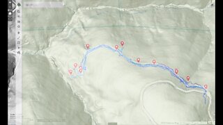
The last time I came up here, I hadn't yet figured out how to calibrate and build the hill shade maps for off-line use. From my last visit:
"At the top switch back, I should have studied the hill shade map a little more as I now see there are 2 more faint road traces there. If I do get back up here, I think I might try crossing the bench above the old road and see if I can re-join that road where it heads back up the canyon."
I struck out trying to get to the road up the center of the gully, but I did stumble upon a straight segment of road that shows up on the map. I had hoped that road would take me to the excavation that shows up on the map, but dense brush blocked my way from this side just like last time from the main road. I did manage to find the place where the main road that runs up to the top of Montebello Ridge joins in with the road that runs up the next canyon.
There's also hints of a road that heads along the side of the canyon that may join up with a road coming up from gate MB10. I may try coming up from that side at some time.
I think I was wrong last time with this guess:
"This bench is nearly 1000 ft. (300m) below the top of Montebello Ridge, where there are a lot of vineyards, some dating from around the time this road was in use. Not sure if this bench was a used that way or more likely it may have been an orchard of some sort. Hoping that hiking across the bench might run into some old trees or grape vine plants from back then."
I now think this area may have instead been a cattle grazing area. This was a popular land use on this ridge prior to the establishment of vineyards. I ran across some old barbed wire and what looked like a wooden fence post on the ground along with the rusty stock tank.
If anyone has any information regarding this area, post up in the comment section below. I've been trying to track down a copy of "History of Black Mountain and Monte Bello Ridge", 1959, George Morell.
I'm finally starting to get a feel for how the vegetation mix changes with elevation and what direction it faces here in the canyon. In most cases, below 1700 ft. it's impenetrable brush. This bench runs from 1600 ft. up to about 1700 ft. making exploring up here very difficult. All this brush has grown up since the cattle grazing stopped. It's interesting to see how this area compares to the wide open grassy meadows just up the canyon at Gold Mine Creek. Slightly different soil type along with 1000's of years of indigenous people actively maintaining them and they remain open grass.
About the USGS HTMC:
https://www.usgs.gov/programs/national-geospatial-program/historical-topographic-maps-preserving-past
View/download maps on the TopoView site:
https://ngmdb.usgs.gov/topoview/
More to come...
Subscribe for more content like this
Comment, rate, share & click the bell icon
And as always, thanks for watching
-
 9:25
9:25
4Crawler
2 years agoMontebello Ridge Road, 2nd Visit
1 -
 7:31
7:31
4Crawler
2 years agoGrizzly Flat North Trail / Middle Road: 3rd Visit
18 -
 2:00
2:00
Dillon Peterson
3 years ago $0.01 earned4K - Arches National Park, UT - Drive Thru in TimeWarp - GoPro 8
513 -
 3:42
3:42
All Natural, GMO, Gluten Free!
7 months agoTripping on Travel: Roseland Park Up Close, Woodstock, CT
8 -
 10:36
10:36
HikingViking
1 month agoUpper Lone Pine Day Use Area @ Lower Crooked National Wild & Scenic River! | BLM | Prineville | 4K
752 -
 10:46
10:46
The Brown Family Workshop
3 years agoBackroad Driving North Bend Washington pt 7
40 -
 14:39
14:39
Cactus Hill
6 months agoBurr Trail Switchbacks in Capitol Reef National Park
24 -
 1:03
1:03
HikingViking
3 months agoBEAUTIFUL AMBIENCE @ "The Cove" Day Use Area (Near Sunrise) @ Timothy Lake! | Mount Hood | Oregon 4K
234 -
 9:19
9:19
RottenDawgEntertainment
3 years agoOld Robe Canyon Trail Hike-Granite Falls, WA
158 -
 12:59
12:59
Coyote Overland
3 years ago $0.02 earnedRimrocker Trail - Part 1 - Montrose, CO to Nucla, CO
115