Brittney's Forecast
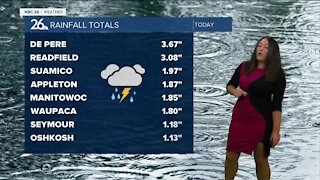
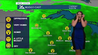
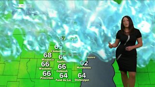
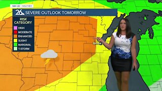
Wednesday will be a warm and humid day with highs in the mid to upper 80s. Starting the day off with sunshine, by the afternoon we transition to a risk of strong and severe thunderstorms by the afternoon and continuing through the overnight hours. Damaging winds and torrential downpours will be the primary risks, but we can't completely rule out a brief spin-up tornado along the leading edge of this line of storms. The cold front will be slowly moving through the area overnight into Thursday providing additional risks for training thunderstorms. This may result in a flooding risk for some areas with the potential of 1-3" of rainfall. Highs Thursday will be cooler, in the mid to upper 70s. Showers and storms will move out of the area by morning, with clearing skies working their way in from the northwest. Friday will be similar temperature wise, cooler, in the upper 70s to near 80. Skies will be sunny which will be a nice start to kick off the weekend. Several days of sunny weather are expected as we head into the weekend and next week. Temperatures will be gradually rising into the mid to upper 80s by Tuesday.
-
 3:36
3:36
WGBA
8 months agoWill it be necessary to have both the AC & the heat on during the same day??
1031 -
 1:27
1:27
WGBA
2 years agoBrittney's Forecast
8 -
 4:01
4:01
WGBA
2 years agoBrittney's Forecast
8 -
 0:33
0:33
WGBA
2 years agoBrittney's Forecast
2 -
 0:58
0:58
WGBA
2 years agoBrittney's Forecast
16 -
 0:56
0:56
WGBA
2 years agoBrittney's Forecast
9 -
 1:05
1:05
WGBA
2 years agoBrittney's Forecast
23 -
 1:18
1:18
WGBA
2 years agoBrittney's Forecast
20 -
 3:52
3:52
WGBA
2 years agoBrittney's Forecast
7 -
 3:34
3:34
WGBA
2 years agoBrittney's NBC 26 weather forecast
18