
TOP 5 COUNTDOWN OF "BEST ONE-PARTY CAMPSITES" @ Clear Lake Campground! | Mount Hood | Oregon | 4K
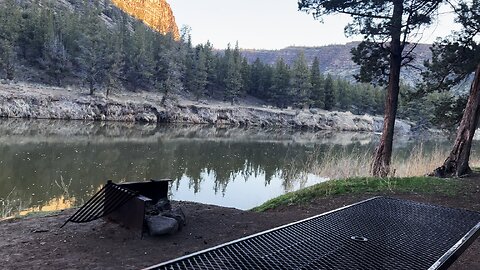
I did this on May 8th, 2024, a few weeks prior to the season opening (Memorial Day, later in May). Please note that any disheveled-ness of the Campground is a purely due to this timing of it not having been cleared to open for the season yet.
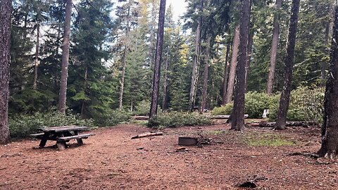
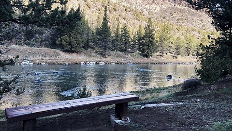
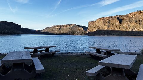
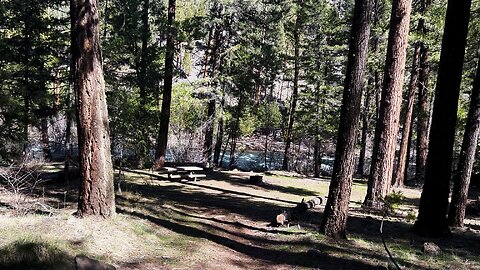
Clear Lake Campground & Day Use Boat Launch Area is nestled in old growth Mount Hood National Forest and without a doubt is in the top tier of Campgrounds in Mount Hood National Forest! There are 28 Campsites - while not directly on the Shoreline, one side of the Campground has individual side trails from each Campsite down to the large Shoreline area, and the other side is tucked up against a pretty epic section of old growth forest giving great shade and a wide forest play area.
The Boat Launch, although completely usable and serviceable, candidly is a bit rutted and bumpy, not nearly as nice as many of the other Boat Launches I've seen in the area, such as many of those over at nearby Timothy Lake as an example. I hope they upgrade the Boat Launch to improve the quality. The Shoreline is absolutely spectacular, you can walk on large sections of it with gorgeous views of Clear Lake!
6
views
1
comment
Ascending Hiking UP the Alpine Zone of Strawberry Mountain Wilderness! | Malheur Eastern Oregon | 4K
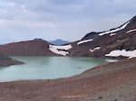
On September 26, 2021, I went to Eastern Oregon, Malheur National Forest, Strawberry Mountain Wilderness, and fully explored all the area highlights in one epic Super Hike - Strawberry Lake, Strawberry Creek, Strawberry Falls, Little Strawberry Lake & Strawberry Mountain.....I did what I like to call "The Full Bushel of Strawberries".....
The length of the Hike is manageable from a Wilderness Adventuring perspective, the most challenging part is the Total Net Elevation Gain if you do every Highlight, although absolutely worth doing it all! I was glad to go during the Autumn Transition and see the warm Fall Color spectrum which only added to the absolute beauty of this spectacular area!
31
views
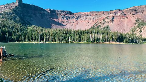
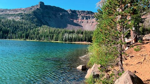
Herd of Deer, Flock of Ducks & Creek Crossing @ Three Creek Lake! | Deschutes | Central Oregon | 4K
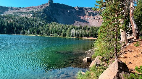
Little Three Creek Lake is a small, gorgeous earth mineral toned Alpine Lake at around 6700 FT Elevation up above Three Creek Lake on the edge of Deschutes National Forest and Three Sisters Wilderness. It is a hike-in only Lake with Backcountry Campsites around the Lake. It is a low effort, high reward ratio Backcountry Camping Zone. There are two hiking trails to Little Three Creek Lake, the traditional North Path (I recommend) and a shorter South Path directly from the edge of Driftwood Campground. If you just hiked to the edge of the Lake and back its approximately 2.6 Miles Roundtrip. I would recommend doing the Full Highlight Hike of hiking to the Lake, hiking beyond the Lake up to the base of the Mountain near the Boulder Avalanche, and continuing on completely circumnavigating this small Lake as well as the unnamed Lake directly to the East of it. If you do the Full Highlight Hike it is approximately 4.3 Miles Roundtrip All-In which is still a pretty short hike with a lot of high quality stunning views.
There is a GREAT Backcountry Campsite on the Westernmost corner of the Lake just before the Hike into Three Sisters Wilderness at the base of the Mountain.
This was hiked on August 31, 2021 with beautiful blue sky and no inclement weather.
It is a self-issue permit at the Trailhead. If you really want to be ambitious, combine this 4.3 Mile Out and Back Hike with the Tam McArthur Rim Hike (I have a Video Playlist of that entire Hike available on my channel!) which is a Recreation.gov permit hike for a full day experience that captures ALL the Hiking Highlights of the Area!
22
views
Exploring the Shoreline of Little Three Creek Lake! | Deschutes Three Sisters | Central Oregon | 4K
Little Three Creek Lake is a small, gorgeous earth mineral toned Alpine Lake at around 6700 FT Elevation up above Three Creek Lake on the edge of Deschutes National Forest and Three Sisters Wilderness. It is a hike-in only Lake with Backcountry Campsites around the Lake. It is a low effort, high reward ratio Backcountry Camping Zone. There are two hiking trails to Little Three Creek Lake, the traditional North Path (I recommend) and a shorter South Path directly from the edge of Driftwood Campground. If you just hiked to the edge of the Lake and back its approximately 2.6 Miles Roundtrip. I would recommend doing the Full Highlight Hike of hiking to the Lake, hiking beyond the Lake up to the base of the Mountain near the Boulder Avalanche, and continuing on completely circumnavigating this small Lake as well as the unnamed Lake directly to the East of it. If you do the Full Highlight Hike it is approximately 4.3 Miles Roundtrip All-In which is still a pretty short hike with a lot of high quality stunning views.
There is a GREAT Backcountry Campsite on the Westernmost corner of the Lake just before the Hike into Three Sisters Wilderness at the base of the Mountain.
This was hiked on August 31, 2021 with beautiful blue sky and no inclement weather.
It is a self-issue permit at the Trailhead. If you really want to be ambitious, combine this 4.3 Mile Out and Back Hike with the Tam McArthur Rim Hike (I have a Video Playlist of that entire Hike available on my channel!) which is a Recreation.gov permit hike for a full day experience that captures ALL the Hiking Highlights of the Area!
22
views
FULL HIKE to Little Three Creek Lake! | Driftwood | Deschutes | Three Sisters | Central Oregon | 4K
Little Three Creek Lake is a small, gorgeous earth mineral toned Alpine Lake at around 6700 FT Elevation up above Three Creek Lake on the edge of Deschutes National Forest and Three Sisters Wilderness. It is a hike-in only Lake with Backcountry Campsites around the Lake. It is a low effort, high reward ratio Backcountry Camping Zone. There are two hiking trails to Little Three Creek Lake, the traditional North Path (I recommend) and a shorter South Path directly from the edge of Driftwood Campground. If you just hiked to the edge of the Lake and back its approximately 2.6 Miles Roundtrip. I would recommend doing the Full Highlight Hike of hiking to the Lake, hiking beyond the Lake up to the base of the Mountain near the Boulder Avalanche, and continuing on completely circumnavigating this small Lake as well as the unnamed Lake directly to the East of it. If you do the Full Highlight Hike it is approximately 4.3 Miles Roundtrip All-In which is still a pretty short hike with a lot of high quality stunning views.
There is a GREAT Backcountry Campsite on the Westernmost corner of the Lake just before the Hike into Three Sisters Wilderness at the base of the Mountain.
This was hiked on August 31, 2021 with beautiful blue sky and no inclement weather.
It is a self-issue permit at the Trailhead. If you really want to be ambitious, combine this 4.3 Mile Out and Back Hike with the Tam McArthur Rim Hike (I have a Video Playlist of that entire Hike available on my channel!) which is a Recreation.gov permit hike for a full day experience that captures ALL the Hiking Highlights of the Area!
39
views
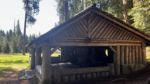
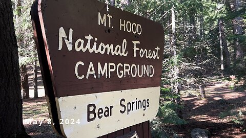
EXPLORING 4K RUSTIC Bear Springs Group Campground Log Cabin Style Shelter! | Mount Hood Oregon | 4K
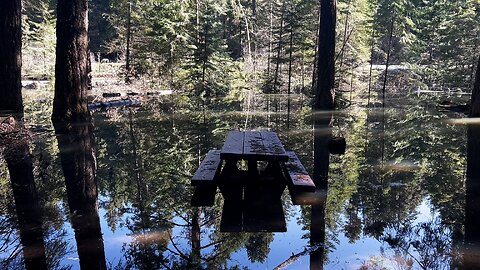
This is a separate Bear Rustic Log Cabin Style Shelter Group Campground (bookable @ Recreation.gov) about a half a block away on the other side of the Forest Road from the main Campground area that I found to be the HIGHLIGHT of the Bear Springs Area with excellent craftsmanship! There is a Forest Meadow and individual Picnic Sites and on the other end of the Meadow at Indian Creek there are more Picnic Sites and a pretty awesome Stone Fireplace.
I did this on May 8, 2024, and part of the Campground was FLOODED - 5A, 6A, 1B, 3B. Since it was my first time here, I don't know if that is an annual snowmelt occurrence or extraordinary circumstances, but my instincts tell me likely extraordinary circumstances although I could be wrong. This Campground is scheduled to open on May 18, 2024, TEN DAYS after this Video Review and I don't possibly see how it could be operational for at least a portion of the Campground given the extraordinary flooding.
Bear Springs Campground is an unusually designed eclectic Campground. It is a GROUP Campground with 4 Quadrant Blocks - A, B, C, & D. At Recreation.gov you book THE ENTIRE BLOCK of around 4 - 6 Campsites!!!!!!!!!!! Candidly, when I reviewed the Campground, it was a last minute addition and I had not had time to research the Campground online, so I assumed by default it had the more of the classic Single-Party Campsite Structure that 99% of Campgrounds have. I will note the official Campground Sign does not say "Group" as most Group Campgrounds typically do, but alas. So please take my narrative commentary with a grain of salt as I was reviewing the area from a Single Family Campsite perspective. I added clarifiers in the edit once I learned it was a Group Campground only during editing and I do still think it is very worth seeing the quality of the individual Campsites contained in this Review so I think it still holds up, I just would have done it a little differently had I known.
15
views
Bear Springs Campground is Currently FLOODED! (May 8th, 2024) | Mount Hood National Forest Oregon 4K
I did this on May 8, 2024, and part of the Campground was FLOODED - 5A, 6A, 1B, 3B. Since it was my first time here, I don't know if that is an annual snowmelt occurrence or extraordinary circumstances, but my instincts tell me likely extraordinary circumstances although I could be wrong. This Campground is scheduled to open on May 18, 2024, TEN DAYS after this Video Review and I don't possibly see how it could be operational for at least a portion of the Campground given the extraordinary flooding.
Bear Springs Campground is an unusually designed eclectic Campground. It is a GROUP Campground with 4 Quadrant Blocks - A, B, C, & D. At Recreation.gov you book THE ENTIRE BLOCK of around 4 - 6 Campsites!!!!!!!!!!! Candidly, when I reviewed the Campground, it was a last minute addition and I had not had time to research the Campground online, so I assumed by default it had the more of the classic Single-Party Campsite Structure that 99% of Campgrounds have. I will note the official Campground Sign does not say "Group" as most Group Campgrounds typically do, but alas. So please take my narrative commentary with a grain of salt as I was reviewing the area from a Single Family Campsite perspective. I added clarifiers in the edit once I learned it was a Group Campground only during editing and I do still think it is very worth seeing the quality of the individual Campsites contained in this Review so I think it still holds up, I just would have done it a little differently had I known.
There is also a separate Bear Rustic Log Shelter Group Campground about a half a block away on the other side of the Forest Road that I found to be the HIGHLIGHT of the Bear Springs Area with excellent craftsmanship! There is a Forest Meadow and individual Picnic Sites and on the other end of the Meadow at Indian Creek there are more Picnic Sites and a pretty awesome Stone Fireplace.
15
views
REVIEWING EACH CAMPSITE @ Bear Springs Campground & Bear Rustic Log Shelter! | Mount Hood Oregon 4K
I did this on May 8, 2024, and part of the Campground was FLOODED - 5A, 6A, 1B, 3B. Since it was my first time here, I don't know if that is an annual snowmelt occurrence or extraordinary circumstances, but my instincts tell me likely extraordinary circumstances although I could be wrong. This Campground is scheduled to open on May 18, 2024, TEN DAYS after this Video Review and I don't possibly see how it could be operational for at least a portion of the Campground given the extraordinary flooding.
Bear Springs Campground is an unusually designed eclectic Campground. It is a GROUP Campground with 4 Quadrant Blocks - A, B, C, & D. At Recreation.gov you book THE ENTIRE BLOCK of around 4 - 6 Campsites!!!!!!!!!!! Candidly, when I reviewed the Campground, it was a last minute addition and I had not had time to research the Campground online, so I assumed by default it had the more of the classic Single-Party Campsite Structure that 99% of Campgrounds have. I will note the official Campground Sign does not say "Group" as most Group Campgrounds typically do, but alas. So please take my narrative commentary with a grain of salt as I was reviewing the area from a Single Family Campsite perspective. I added clarifiers in the edit once I learned it was a Group Campground only during editing and I do still think it is very worth seeing the quality of the individual Campsites contained in this Review so I think it still holds up, I just would have done it a little differently had I known.
There is also a separate Bear Rustic Log Shelter Group Campground about a half a block away on the other side of the Forest Road that I found to be the HIGHLIGHT of the Bear Springs Area with excellent craftsmanship! There is a Forest Meadow and individual Picnic Sites and on the other end of the Meadow at Indian Creek there are more Picnic Sites and a pretty awesome Stone Fireplace.
51
views
FULL HIKE Mount Hood Wilderness to Lower & Upper Twin Lakes! | Pacific Crest Trail | Oregon | 4K
Here are the Chapters & Timestamps:
0:00 Hiking by Mossy Trees in Mount Hood Wilderness
0:20 How Blue Diamond Tree Markers Work in Snowy Winter
1:01 La Nina Impact on Delaying the Annual Snowfall & Elevation Data
1:54 Biodiversity Ecological Footprint Differences Between Mount Bachelor vs. Mount Hood
4:21 Misty Fog Enveloping the Forest as we Hike
4:37 Just Turned Right at Trail Junction and Full Super Loop Hike Itinerary
5:04 Arriving at Lower Twin Lake
6:25 Checking out the Backcountry Campsites around Lower Twin Lake, particularly 2 on the North Shoreline and 1 on the West Shoreline
8:45 Circumnavigating Lower Twin Lake by hiking optional add-on 1-Mile Shoreline Loop
11:39 Final Look at Gorgeous Foggy Lower Twin Lake
12:00 Ascending the Forest to Upper Twin Lake & Arriving at Upper Twin Lake with a sheet of ice forming on its surface
On December 3, 2021, I went to Frog Lake Sno-Park, aka the Pacific Crest Trailhead to Lower & Upper Twin Lakes traversing gorgeous Mount Hood Wilderness. I was expecting some snow given that it was Winter and had even brought several kits with me aka snowshoes to decide the right traction control based on the conditions, but much to my surprise there was no snow whatsoever on the Trail. The cyclical weather phenomenon known as La Nina had delayed the start of the annual snow deluge by about 3 weeks, even causing one of the latest opening delays of the nearby Ski Lodges in history.
I was the only one on the Trail and in the entire wider Forest area for my entire hike down to Lower Twin Lake and up to Upper Twin Lake. I checked out the Backcountry Campsites around the Lake and added the optional 1-Mile Shoreline Loop around Lower Twin Lake. After hiking up to Upper Twin Lake I continued past it to reconnect with the Pacific Crest Trail and return back to trailhead by completing the Loop.
The entire Hike is approximately 7.2 Miles, 950 FT Elevation Gain through Classic Old Growth Forest, with a 1-Mile additional add-on option of circumnavigating Lower Twin Lake (I highly recommend!) for a total of 8.2 Miles. It was in the Low 20's temperature wise and thick, dense fog rolled in at Lower Twin Lake.
24
views
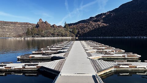
Which Arm of Lake Billy Chinook is the BEST to Catch Fish? | The Cove Palisades State Park Oregon 4K
Crooked? Deschutes? Metolius? Which Arm of Lake Billy Chinook @ The Cove Palisades State Park in Central Oregon is the BEST to Catch Fish?
This 4K Video captures the Lower Deschutes Day Use Area Boat Ramp/Launch/Dock, the Floating Deployable Restrooms, and and finishes with some Silent Perspectives of absolutely gorgeous and incredible Lake Billy Chinook from the Lower Deschutes Day Use Area Zone.
***Please note that Google Maps is wrong. There is an Upper Deschutes Day Use Area AND a Lower Deschutes Day Use Area. They are nearby each other, both have their own Ramp/Launch/Dock, and they are connected by a Shoreline Trail. For some reason Google Maps has the Upper Deschutes Day Use Area INACCURATELY labeled as the Lower Deschutes Day Use Area, and doesn't have the Lower Deschutes Day Use Area even labeled AT ALL even though it acknowledges the Boat Ramp and infrastructure is there.....so this IS correct, Google Maps is wrong.***
The Cove Palisades State Park is easily a Top 3 State Park in the entire State of Oregon! Lake Billy Chinook's claim to fame is that its the confluence of 3 National Wild & Scenic Rivers - Crooked River, Deschutes River & Metolius River into a truly EPIC Lake-River-Canyon High Desert Wonderland! Thus this multi-tendrilled Lake is broken up into the Crooked River Arm, Deschutes River Arm & Metolius River Arm, each with its own very well developed infrastructure of Day Use Areas, Boat Ramp/Launches and very well groomed & manicured Shoreline Hiking Trails. Lake Billy Chinook is truly a World-Class Watersport Mecca of Boating, Fishing & Kayaking.
This area was explored on March 19, 2024. The weather was in the 30's in the AM up the the 50's by late afternoon. Due to some pre-scheduled hydroelectric dam work by PGE, the water levels were 2 FT - 5 FT lower than normal, with water levels expected to return back up to normal levels within weeks before peak season.
The road is very well paved throughout The Cove Palisades State Park and all the way through to Perry South Campground. From Perry South Campground to Monty Campground it is a relatively bumpy Forest Road - most cars should be able to make it if you drive slowly and cautiously, particularly around some blind corners on a very steep road, so exercise maximum caution driving to Monty Campground! That said, if done prudently, it is not a difficult drive, high clearance and 4WD are NOT required in my humble opinion. Always check for weather and of course do so at your own risk!
20
views
Walking the Shoreline @ Crooked River Day Use Area | Cove Palisades State Park Lake Billy Chinook 4K
This 4K Video walks the beautiful Shoreline of the Crooked River Day Use Area and highlights an EPIC Picnic Site of the incredible Crooked Arm of Lake Billy Chinook!
The Cove Palisades State Park is easily a Top 3 State Park in the entire State of Oregon! Lake Billy Chinook's claim to fame is that its the confluence of 3 National Wild & Scenic Rivers - Crooked River, Deschutes River & Metolius River into a truly EPIC Lake-River-Canyon High Desert Wonderland! Thus this multi-tendrilled Lake is broken up into the Crooked River Arm, Deschutes River Arm & Metolius River Arm, each with its own very well developed infrastructure of Day Use Areas, Boat Ramp/Launches and very well groomed & manicured Shoreline Hiking Trails. Lake Billy Chinook is truly a World-Class Watersport Mecca of Boating, Fishing & Kayaking.
This area was explored on March 19, 2024. The weather was in the 30's in the AM up the the 50's by late afternoon. Due to some pre-scheduled hydroelectric dam work by PGE, the water levels were 2 FT - 5 FT lower than normal, with water levels expected to return back up to normal levels within weeks before peak season.
The road is very well paved throughout The Cove Palisades State Park and all the way through to Perry South Campground. From Perry South Campground to Monty Campground it is a relatively bumpy Forest Road - most cars should be able to make it if you drive slowly and cautiously, particularly around some blind corners on a very steep road, so exercise maximum caution driving to Monty Campground! That said, if done prudently, it is not a difficult drive, high clearance and 4WD are NOT required in my humble opinion. Always check for weather and of course do so at your own risk!
38
views
FULL HIKE Pacific Crest Trail Loop to Lower & Upper Twin Lakes! | Mount Hood Wilderness Oregon | 4K
0:00 Arriving at Junction on Pacific Crest Trail to Turn Right onto Twin Lakes Trail towards Lower Twin Lake
4:58 Arriving at Lower Twin Lake
6:26 Checking out the Backcountry Campsites around Lower Twin Lake, particularly 2 on the North Shoreline and 1 on the West Shoreline
10:13 Circumnavigating Lower Twin Lake by hiking optional add-on 1-Mile Shoreline Loop
13:20 Rope Swing & Final Look at Foggy Lower Twin Lake
13:53 Ascending the Forest to Upper Twin Lake & Arriving at Upper Twin Lake with a sheet of ice forming on its surface
On December 3, 2021, I went to Frog Lake Sno-Park, aka the Pacific Crest Trailhead to Lower & Upper Twin Lakes traversing gorgeous Mount Hood Wilderness. I was expecting some snow given that it was Winter and had even brought several kits with me aka snowshoes to decide the right traction control based on the conditions, but much to my surprise there was no snow whatsoever on the Trail. The cyclical weather phenomenon known as La Nina had delayed the start of the annual snow deluge by about 3 weeks, even causing one of the latest opening delays of the nearby Ski Lodges in history.
I was the only one on the Trail and in the entire wider Forest area for my entire hike down to Lower Twin Lake and up to Upper Twin Lake. I checked out the Backcountry Campsites around the Lake and added the optional 1-Mile Shoreline Loop around Lower Twin Lake. After hiking up to Upper Twin Lake I continued past it to reconnect with the Pacific Crest Trail and return back to trailhead by completing the Loop.
The entire Hike is approximately 7.2 Miles, 950 FT Elevation Gain through Classic Old Growth Forest, with a 1-Mile additional add-on option of circumnavigating Lower Twin Lake (I highly recommend!) for a total of 8.2 Miles. It was in the Low 20's temperature wise and thick, dense fog rolled in at Lower Twin Lake.
54
views
Upper Lone Pine Day Use Area @ Lower Crooked National Wild & Scenic River! | BLM | Prineville | 4K
Here are the Chapters & Timestamps:
0:00 Sign for Upper Lone Pine Day Use Area & Walking the Parking Lot to the two Shoreline Hiking Trailheads
0:57 Hiking the first Trail descending down to Shoreline of Lower Crooked National Wild & Scenic River
3:37 Hiking the second Trail descending down to Shoreline of Lower Crooked National Wild & Scenic River
5:37 A Montage of Silent 4K Perspectives of the Upper Lone Pine Day Use Area Zone of Lower Crooked National Wild & Scenic River
The Lower Crooked National Wild & Scenic River is a extremely high quality River Canyon Wonderland Zone consisting of 9 Developed Campgrounds, 2 Day Use Areas, 1 Dam, 1 Dedicated Boat Ramp, and 1 World Class Hiking Trail called "Chimney Rock" that ascends to a truly spectacular geological formation. This area is operated by the Bureau of Land Management (BLM), and is in the SW Quadrant of the greater Prineville area to the West of the Prineville Reservoir State Park.
Crooked River is divided into 3 National Wild & Scenic River Designated Smaller Sections - THIS ONE is the greater "Chimney Rock" Segment, named for the geological formation. Chimney Rock is also the name of the Trail, as well as the name of the Campground adjacent to the Trailhead.....clearly Chimney Rock has left its impression and mark on the nomenclature of this high desert wonderland river canyon area. To be clear, THIS ENTIRE SECTION of 9 Developed Campgrounds, 2 Day Use Areas, 1 Dam, 1 Dedicated Boat Ramp, and 1 World Class Hiking Trail is called the "Chimney Rock" Segment of Lower Crooked National Wild & Scenic River.
This Playlist consists of:
- Reviewing Each Campsite @ Castle Rock Campground
- Highlight of a Beaver Running Down the River Shoreline
- Reviewing Each Campsite @ Stillwater Campground
- Reviewing Each Campsite @ Lone Pine Campground
- Reviewing Each Campsite @ Lower Palisades Campground
- Reviewing Each Campsite @ Chimney Rock Campground
- Reviewing Each Campsite @ Cobble Rock Campground
- Reviewing Each Campsite @ Post Pile Campground
- Reviewing Each Campsite @ Poison Butte Campground
- Reviewing Each Campsite @ Big Bend Campground
- Reviewing Greenwood Day Use Area
- Reviewing Upper Lone Pine Day Use Area (THIS ONE!)
- Bowman Dam
- Powder House Cove Boat Ramp/Launch/Dock
- FULL HIKE of Chimney Rock Trail
- A few Highlight Videos & Perspectives of Chimney Rock Trail
- SILENT 4K PERSPECTIVES COMPILATION of the Entire Chimney Rock Segment of Lower Crooked National Wild & Scenic River
These Videos were not all made in one day, the size of the area and logistics make that impossible. These videos were made on 3/26/24 and 4/2/24, both blue bird sky days with lows in the 30's and highs in the 70's.
67
views
2
comments
The Two EPIC Benches of Chimney Rock! | Lower Crooked River | BLM | Prineville | Central Oregon | 4K
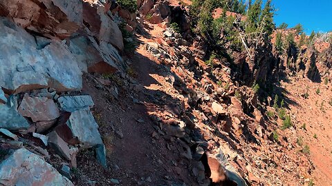
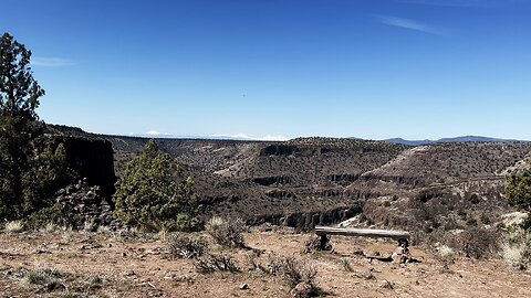
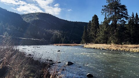
This was a Day Hike, starting at Chimney Rock Trailhead (across the road from Chimney Rock Campground), operated by the BLM (Bureau of Land Management), going 2.8 Miles Roundtrip, about 500 FT Elevation Gain, to the base of the world famous geological formation known as "Chimney Rock". The trail ascends a high desert wonderland canyon surrounded by juniper trees and sagebrush, with some great views looking down on Lower Crooked National Wild & Scenic River as you ascend. There are portions of the trail that are close to the edge of the canyon with a steep precipice - it never felt unsafe to me, but one must practice Situational Awareness and it may not be a good idea to bring kids up there unless they are well disciplined in safety protocols. Once you ascend the canyon you get up to a large plateau on the canyon edifice to explore for a while (a bench was particularly awesome) that yields direct views of the Mountains of Central Oregon - Three Sisters, Broken Top & Jefferson. It culminates with views of Chimney Rock, a lone geological formation standing high surrounded by high desert. I would recommend looking to the left of Chimney Rock down on a great canyon wide perspective of Lower Crooked National Wild & Scenic River snaking through the canyon.
Crooked River is divided into 3 National Wild & Scenic River Designated Sections - this one is the "Chimney Rock" Segment, named for this geological formation. Chimney Rock is also the name of the Trail, as well as the name of the Campground adjacent to the Trailhead.....clearly Chimney Rock has left its impression and mark on the nomenclature of this high desert wonderland river canyon area.
This is a very hot area, it is the high desert with direct sun almost the entire hike. I did this on 4/2/24, with a low of 35F and a high of 77F - I would not recommend doing this at the hottest time of day, particularly during Summer months of 80F - 100F, as the combination of steep elevation gain exertion and direct hot sun could be materialize into a dangerous hydration issue very very quickly.
45
views
TWO BEAVER ENCOUNTERS on the Shoreline of Lower Crooked River! | BLM | Prineville Central Oregon 4K
Here are the Chapters & Timestamps:
0:00 Beaver Runs Quickly By on Shoreline (Sighting #1)
0:35 Spot the Beaver on the Shoreline straight ahead and watch it run down the Shoreline (Sighting #2)
1:01 Gorgeous Approach to Edge of Shoreline of Lower Crooked National Wild & Scenic River
2:23 A Montage of Silent 4K Perspectives of Lower Crooked National Wild & Scenic River of the Zones Adjacent to Castle Rock Campground
The Lower Crooked National Wild & Scenic River is a extremely high quality River Canyon Wonderland Zone consisting of 9 Developed Campgrounds, 2 Day Use Areas, 1 Dam, 1 Dedicated Boat Ramp, and 1 World Class Hiking Trail called "Chimney Rock" that ascends to a truly spectacular geological formation. This area is operated by the Bureau of Land Management (BLM), and is in the SW Quadrant of the greater Prineville area to the West of the Prineville Reservoir State Park.
Crooked River is divided into 3 National Wild & Scenic River Designated Smaller Sections - THIS ONE is the greater "Chimney Rock" Segment, named for the geological formation. Chimney Rock is also the name of the Trail, as well as the name of the Campground adjacent to the Trailhead.....clearly Chimney Rock has left its impression and mark on the nomenclature of this high desert wonderland river canyon area. To be clear, THIS ENTIRE SECTION of 9 Developed Campgrounds, 2 Day Use Areas, 1 Dam, 1 Dedicated Boat Ramp, and 1 World Class Hiking Trail is called the "Chimney Rock" Segment of Lower Crooked National Wild & Scenic River.
This Playlist consists of:
- Reviewing Each Campsite @ Castle Rock Campground
- Highlight of a Beaver Running Down the River Shoreline (THIS ONE!)
- Reviewing Each Campsite @ Stillwater Campground
- Reviewing Each Campsite @ Lone Pine Campground
- Reviewing Each Campsite @ Lower Palisades Campground
- Reviewing Each Campsite @ Chimney Rock Campground
- Reviewing Each Campsite @ Cobble Rock Campground
- Reviewing Each Campsite @ Post Pile Campground
- Reviewing Each Campsite @ Poison Butte Campground
- Reviewing Each Campsite @ Big Bend Campground
- Reviewing Greenwood Day Use Area
- Reviewing Upper Lone Pine Day Use Area
- Bowman Dam
- Powder House Cove Boat Ramp/Launch/Dock
- FULL HIKE of Chimney Rock Trail
- A few Highlight Videos & Perspectives of Chimney Rock Trail
- SILENT 4K PERSPECTIVES COMPILATION of the Entire Chimney Rock Segment of Lower Crooked National Wild & Scenic River
These Videos were not all made in one day, the size of the area and logistics make that impossible. These videos were made on 3/26/24 and 4/2/24, both blue bird sky days with lows in the 30's and highs in the 70's.
102
views
Greenwood Day Use Area @ Lower Crooked National Wild & Scenic River! | BLM | Prineville Oregon | 4K
The Lower Crooked National Wild & Scenic River is a extremely high quality River Canyon Wonderland Zone consisting of 9 Developed Campgrounds, 2 Day Use Areas, 1 Dam, 1 Dedicated Boat Ramp, and 1 World Class Hiking Trail called "Chimney Rock" that ascends to a truly spectacular geological formation. This area is operated by the Bureau of Land Management (BLM), and is in the SW Quadrant of the greater Prineville area to the West of the Prineville Reservoir State Park.
Crooked River is divided into 3 National Wild & Scenic River Designated Smaller Sections - THIS ONE is the greater "Chimney Rock" Segment, named for the geological formation. Chimney Rock is also the name of the Trail, as well as the name of the Campground adjacent to the Trailhead.....clearly Chimney Rock has left its impression and mark on the nomenclature of this high desert wonderland river canyon area. To be clear, THIS ENTIRE SECTION of 9 Developed Campgrounds, 2 Day Use Areas, 1 Dam, 1 Dedicated Boat Ramp, and 1 World Class Hiking Trail is called the "Chimney Rock" Segment of Lower Crooked National Wild & Scenic River.
This Playlist consists of:
- Reviewing Each Campsite @ Castle Rock Campground
- Highlight of a Beaver Running Down the River Shoreline
- Reviewing Each Campsite @ Stillwater Campground
- Reviewing Each Campsite @ Lone Pine Campground
- Reviewing Each Campsite @ Lower Palisades Campground
- Reviewing Each Campsite @ Chimney Rock Campground
- Reviewing Each Campsite @ Cobble Rock Campground
- Reviewing Each Campsite @ Post Pile Campground
- Reviewing Each Campsite @ Poison Butte Campground
- Reviewing Each Campsite @ Big Bend Campground
- Reviewing Greenwood Day Use Area (THIS ONE!)
- Reviewing Upper Lone Pine Day Use Area
- Bowman Dam
- Powder House Cove Boat Ramp/Launch/Dock
- FULL HIKE of Chimney Rock Trail
- A few Highlight Videos & Perspectives of Chimney Rock Trail
- SILENT 4K PERSPECTIVES COMPILATION of the Entire Chimney Rock Segment of Lower Crooked National Wild & Scenic River
These Videos were not all made in one day, the size of the area and logistics make that impossible. These videos were made on 3/26/24 and 4/2/24, both blue bird sky days with lows in the 30's and highs in the 70's.
41
views
REVIEWING EACH CAMPSITE @ Stillwater Campground! | Lower Crooked River | BLM | Prineville Oregon 4K
The Lower Crooked National Wild & Scenic River is a extremely high quality River Canyon Wonderland Zone consisting of 9 Developed Campgrounds, 2 Day Use Areas, 1 Dam, 1 Dedicated Boat Ramp, and 1 World Class Hiking Trail called "Chimney Rock" that ascends to a truly spectacular geological formation. This area is operated by the Bureau of Land Management (BLM), and is in the SW Quadrant of the greater Prineville area to the West of the Prineville Reservoir State Park.
Crooked River is divided into 3 National Wild & Scenic River Designated Smaller Sections - THIS ONE is the greater "Chimney Rock" Segment, named for the geological formation. Chimney Rock is also the name of the Trail, as well as the name of the Campground adjacent to the Trailhead.....clearly Chimney Rock has left its impression and mark on the nomenclature of this high desert wonderland river canyon area. To be clear, THIS ENTIRE SECTION of 9 Developed Campgrounds, 2 Day Use Areas, 1 Dam, 1 Dedicated Boat Ramp, and 1 World Class Hiking Trail is called the "Chimney Rock" Segment of Lower Crooked National Wild & Scenic River.
This Playlist consists of:
- Reviewing Each Campsite @ Castle Rock Campground
- Highlight of a Beaver Running Down the River Shoreline
- Reviewing Each Campsite @ Stillwater Campground (THIS ONE!)
- Reviewing Each Campsite @ Lone Pine Campground
- Reviewing Each Campsite @ Lower Palisades Campground
- Reviewing Each Campsite @ Chimney Rock Campground
- Reviewing Each Campsite @ Cobble Rock Campground
- Reviewing Each Campsite @ Post Pile Campground
- Reviewing Each Campsite @ Poison Butte Campground
- Reviewing Each Campsite @ Big Bend Campground
- Reviewing Greenwood Day Use Area
- Reviewing Upper Lone Pine Day Use Area
- Bowman Dam
- Powder House Cove Boat Ramp/Launch/Dock
- FULL HIKE of Chimney Rock Trail
- A few Highlight Videos & Perspectives of Chimney Rock Trail
- SILENT 4K PERSPECTIVES COMPILATION of the Entire Chimney Rock Segment of Lower Crooked National Wild & Scenic River
These Videos were not all made in one day, the size of the area and logistics make that impossible. These videos were made on 3/26/24 and 4/2/24, both blue bird sky days with lows in the 30's and highs in the 70's.
56
views
Lower Deschutes Day Use Area Boat Launch @ The Cove Palisades State Park! | Lake Billy Chinook | 4K
This 4K Video captures the Lower Deschutes Day Use Area Boat Ramp/Launch/Dock, the Floating Deployable Restrooms, the Day Use Picnic Sites on the Shoreline, and the Designated Swimming Area of the incredible Deschutes Arm of Lake Billy Chinook, and finishes with some Silent Perspectives of absolutely gorgeous and incredible Lake Billy Chinook!
***Please note that Google Maps is wrong. There is an Upper Deschutes Day Use Area AND a Lower Deschutes Day Use Area. They are nearby each other, both have their own Ramp/Launch/Dock, and they are connected by a Shoreline Trail. For some reason Google Maps has the Upper Deschutes Day Use Area INACCURATELY labeled as the Lower Deschutes Day Use Area, and doesn't have the Lower Deschutes Day Use Area even labeled AT ALL even though it acknowledges the Boat Ramp and infrastructure is there.....so this IS correct, Google Maps is wrong.***
The Cove Palisades State Park is easily a Top 3 State Park in the entire State of Oregon! Lake Billy Chinook's claim to fame is that its the confluence of 3 National Wild & Scenic Rivers - Crooked River, Deschutes River & Metolius River into a truly EPIC Lake-River-Canyon High Desert Wonderland! Thus this multi-tendrilled Lake is broken up into the Crooked River Arm, Deschutes River Arm & Metolius River Arm, each with its own very well developed infrastructure of Day Use Areas, Boat Ramp/Launches and very well groomed & manicured Shoreline Hiking Trails. Lake Billy Chinook is truly a World-Class Watersport Mecca of Boating, Fishing & Kayaking.
This area was explored on March 19, 2024. The weather was in the 30's in the AM up the the 50's by late afternoon. Due to some pre-scheduled hydroelectric dam work by PGE, the water levels were 2 FT - 5 FT lower than normal, with water levels expected to return back up to normal levels within weeks before peak season.
The road is very well paved throughout The Cove Palisades State Park and all the way through to Perry South Campground. From Perry South Campground to Monty Campground it is a relatively bumpy Forest Road - most cars should be able to make it if you drive slowly and cautiously, particularly around some blind corners on a very steep road, so exercise maximum caution driving to Monty Campground! That said, if done prudently, it is not a difficult drive, high clearance and 4WD are NOT required in my humble opinion. Always check for weather and of course do so at your own risk!
35
views
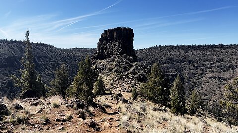
Final Approach Hike to Chimney Rock! | Lower Crooked River | BLM | Prineville | Central Oregon | 4K
This was a Day Hike, starting at Chimney Rock Trailhead (across the road from Chimney Rock Campground), operated by the BLM (Bureau of Land Management), going 2.8 Miles Roundtrip, about 500 FT Elevation Gain, to the base of the world famous geological formation known as "Chimney Rock". The trail ascends a high desert wonderland canyon surrounded by juniper trees and sagebrush, with some great views looking down on Lower Crooked National Wild & Scenic River as you ascend. There are portions of the trail that are close to the edge of the canyon with a steep precipice - it never felt unsafe to me, but one must practice Situational Awareness and it may not be a good idea to bring kids up there unless they are well disciplined in safety protocols. Once you ascend the canyon you get up to a large plateau on the canyon edifice to explore for a while (a bench was particularly awesome) that yields direct views of the Mountains of Central Oregon - Three Sisters, Broken Top & Jefferson. It culminates with views of Chimney Rock, a lone geological formation standing high surrounded by high desert. I would recommend looking to the left of Chimney Rock down on a great canyon wide perspective of Lower Crooked National Wild & Scenic River snaking through the canyon.
Crooked River is divided into 3 National Wild & Scenic River Designated Sections - this one is the "Chimney Rock" Segment, named for this geological formation. Chimney Rock is also the name of the Trail, as well as the name of the Campground adjacent to the Trailhead.....clearly Chimney Rock has left its impression and mark on the nomenclature of this high desert wonderland river canyon area.
This is a very hot area, it is the high desert with direct sun almost the entire hike. I did this on 4/2/24, with a low of 35F and a high of 77F - I would not recommend doing this at the hottest time of day, particularly during Summer months of 80F - 100F, as the combination of steep elevation gain exertion and direct hot sun could be materialize into a dangerous hydration issue very very quickly.
31
views
Crooked River Day Use Area @ The Cove Palisades State Park! | Lake Billy Chinook | Central Oregon 4K
Here is the FULL LIST of Chapters & Timestamps:
0:00 The Cove Palisades State Park Entrance Sign and Accessing Crooked River Day Use Area Main Shoreline
5:35 Walking Down the Shoreline of Lake Billy Chinook
6:56 Picnic Single Site Day Use Area
7:29 Picnic Group Site Day Use Area
This 4K Video captures the Crooked River Day Use Area Shoreline & Picnic Site Area of the incredible Crooked Arm of Lake Billy Chinook, and includes some Silent Shoreline Perspectives as well.
The Cove Palisades State Park is easily a Top 3 State Park in the entire State of Oregon! Lake Billy Chinook's claim to fame is that its the confluence of 3 National Wild & Scenic Rivers - Crooked River, Deschutes River & Metolius River into a truly EPIC Lake-River-Canyon High Desert Wonderland! Thus this multi-tendrilled Lake is broken up into the Crooked River Arm, Deschutes River Arm & Metolius River Arm, each with its own very well developed infrastructure of Day Use Areas, Boat Ramp/Launches and very well groomed & manicured Shoreline Hiking Trails. Lake Billy Chinook is truly a World-Class Watersport Mecca of Boating, Fishing & Kayaking.
This area was explored on March 19, 2024. The weather was in the 30's in the AM up the the 50's by late afternoon. Due to some pre-scheduled hydroelectric dam work by PGE, the water levels were 2 FT - 5 FT lower than normal, with water levels expected to return back up to normal levels within weeks before peak season.
The road is very well paved throughout The Cove Palisades State Park and all the way through to Perry South Campground. From Perry South Campground to Monty Campground it is a relatively bumpy Forest Road - most cars should be able to make it if you drive slowly and cautiously, particularly around some blind corners on a very steep road, so exercise maximum caution driving to Monty Campground! That said, if done prudently, it is not a difficult drive, high clearance and 4WD are NOT required in my humble opinion. Always check for weather and of course do so at your own risk!
43
views
1
comment
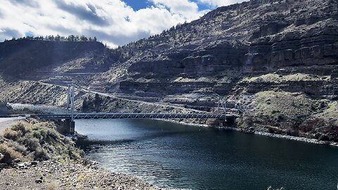
The Two EPIC Jordan Bridges Crossing Lake Billy Chinook @ The Cove Palisades State Park! | Oregon 4K
There are two Bridges in The Cove Palisades State Park area, one called the SE Jordan Bridge, the other the SW Jordan Bridge, going over the Crooked Arm and Deschutes Arm of Lake Billy Chinook. One is a two lane Bridge, the other a single lane Bridge, both very EPIC!
This area was explored on March 19, 2024. The weather was in the 30's in the AM up the the 50's by late afternoon. The road is very well paved throughout The Cove Palisades State Park and all the way through to Perry South Campground. If done prudently, it is not a difficult drive, high clearance and 4WD are NOT required in my humble opinion. Always check for weather!
The Cove Palisades State Park is easily a Top 3 State Park in the entire State of Oregon! Lake Billy Chinook's claim to fame is that its the confluence of 3 National Wild & Scenic Rivers - Crooked River, Deschutes River & Metolius River into a truly EPIC Lake-River-Canyon High Desert Wonderland! Thus this multi-tendrilled Lake is broken up into the Crooked River Arm, Deschutes River Arm & Metolius River Arm, each with its own very well developed infrastructure of Day Use Areas, Boat Ramp/Launches and very well groomed & manicured Shoreline Hiking Trails. Lake Billy Chinook is truly a World-Class Watersport Mecca of Boating, Fishing & Kayaking. This 4K Video Playlist captures the Highlights and Points of Interest of The Cove Palisades State Park and the Greater Lake Billy Chinook Area:
- Full Video from the official Park Entrance Sign stopping at every point of interest along the way up thru Monty Campground on the Metolius River!
- Crooked River Day Use Area
- Lower Deschutes River Day Use Area
- Upper Deschutes River Day Use Area
- Petroglyph of Crooked River & "The Island" National Natural Landmark
- Full Hike of Tam-a-lau Trail
- Both Jordan Bridges (THIS VIDEO!)
- Hoodoo Trailhead to Metolius Balancing Rocks
- Reviewing Each Campsite @ Perry South Campground and exploring the Boat Ramp/Launch and Shoreline Hiking Trail
- Reviewing Each Campsite @ Monty Campground
Due to some pre-scheduled hydroelectric dam work by PGE, the water levels were 2 FT - 5 FT lower than normal, with water levels expected to return back up to normal levels within weeks before peak season.
58
views
TOP 3 COUNTDOWN OF BEST "ONE-PARTY CAMPSITES" @ Monty Campground! | Metolius River Central Oregon 4K
Monty Campground is a small, rustic, spacious very high quality 12 Site Campground in Deschutes National Forest along the shoreline of National Wild & Scenic Metolius River. It is located in the NW Quadrant of Lake Billy Chinook on the River segment before the Metolius Arm of Lake Billy Chinook. It is NOT part of The Cove Palisades State Park, but is part of the greater Lake Billy Chinook complex area.
It is a First Come, First Served and $18 per Night as of March 2024. As far as the open season - it is pretty much open year round from my understanding....candidly it's a bit of an enigma. If you go the the Forestry Service website it says it is closed, but if you actually physically drive there it is open, the same discrepancy I observed at Perry South Campground just a few minutes down the Forest Road. So ultimately I would say it's a caveat emptor "buyer beware" situation, so do so at your own risk!
My favorite Campsites at Monty Campground were as follows:
1st Place - Campsite #8
2nd Place - Campsite #2
3rd Place - Campsite #4
This area was explored on March 19, 2024. The weather was in the 30's in the AM up the the 50's by late afternoon. The road is very well paved throughout The Cove Palisades State Park and all the way through to Perry South Campground. From Perry South Campground to Monty Campground it is a relatively bumpy Forest Road - most cars should be able to make it if you drive slowly and cautiously, particularly around some blind corners on a very steep road, so exercise maximum caution driving to Monty Campground! That said, if done prudently, it is not a difficult drive, high clearance and 4WD are NOT required in my humble opinion. Always check for weather!
The Cove Palisades State Park is easily a Top 3 State Park in the entire State of Oregon! Lake Billy Chinook's claim to fame is that its the confluence of 3 National Wild & Scenic Rivers - Crooked River, Deschutes River & Metolius River into a truly EPIC Lake-River-Canyon High Desert Wonderland! Thus this multi-tendrilled Lake is broken up into the Crooked River Arm, Deschutes River Arm & Metolius River Arm, each with its own very well developed infrastructure of Day Use Areas, Boat Ramp/Launches and very well groomed & manicured Shoreline Hiking Trails. Lake Billy Chinook is truly a World-Class Watersport Mecca of Boating, Fishing & Kayaking. This 4K Video Playlist captures the Highlights and Points of Interest of The Cove Palisades State Park and the Greater Lake Billy Chinook Area:
- Full Video from the official Park Entrance Sign stopping at every point of interest along the way up thru Monty Campground on the Metolius River!
- Crooked River Day Use Area
- Lower Deschutes River Day Use Area
- Upper Deschutes River Day Use Area
- Petroglyph of Crooked River & "The Island" National Natural Landmark
- Full Hike of Tam-a-lau Trail
- Both Jordan Bridges
- Hoodoo Trailhead to Metolius Balancing Rocks
- Reviewing Each Campsite @ Perry South Campground and exploring the Boat Ramp/Launch and Shoreline Hiking Trail
- Reviewing Each Campsite @ Monty Campground
Due to some pre-scheduled hydroelectric dam work by PGE, the water levels were 2 FT - 5 FT lower than normal, with water levels expected to return back up to normal levels within weeks before peak season.
52
views
Good Morning from Prineville in Central Oregon @ Lower Crooked National Wild & Scenic River! | 4K
4K View of GORGEOUS Lower Crooked National Wild & Scenic River in Prineville, Central Oregon. This is West of the Prineville Reservoir State Park in an area of 9 Campgrounds, 2 Day Use Areas, 1 Dam, 1 Dedicated Boat Ramp, and 1 World-Class Hiking Trail operated by the Bureau of Land Management (BLM).
Crooked River is divided into 3 National Wild & Scenic River Designated Sections - THIS ONE is the "Chimney Rock" Segment, named for this geological formation. Chimney Rock is also the name of the main premier Hiking Trail, as well as the name of the Campground adjacent to the Trailhead.....clearly Chimney Rock has left its impression and mark on the nomenclature of this high desert wonderland river canyon area.
This is a very hot area, it is the high desert with direct sun. I did this on 4/2/24, with a low of 35F and a high of 77F.
49
views
1
comment
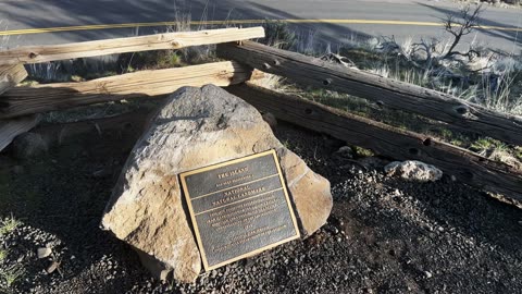
Crooked River Petroglyph & "The Island" Natural Landmark! | Lake Billy Chinook | Central Oregon | 4K
Crooked River Petroglyph and "The Island" National Natural Landmark are historical landmark points of interest right beside each other in The Cove Palisades State Park in Central Oregon. The area is just before the Lower Deschutes River Day Use Area on the Left coming from Madras. The informational placards are rich with history and interesting and it is a low effort to high reward ratio payoff, so I highly recommend!
90
views

Oregon Hoodoos Trailhead to Metolius Balancing Rocks! | Lake Billy Chinook | Central Oregon | 4K
The Oregon Hoodoos Trailhead to Metolius Balancing Rocks is a hidden gem on the South side of Lake Billy Chinook. The parking is a little shoulder on the road big enough for a few vehicles. The hike itself is only a couple tenths of a mile to a lookout point with an informational placard and a grand expansive view of Metolius Balancing Rocks with the Metolius Arm of Lake Billy Chinook in the background. This is a classic low effort, high reward ratio hike which I highly recommend. I like to refer to this area as the Stonehenge of Central Oregon!
86
views