
Burgess Falls, Tennessee -- 4K Cinematic
The Burgess Falls can be viewed from either a platform in the Burgess Falls State Park, or you can opt to kayak to the base of the falls. The kayak we did was about 3 miles round trip, so plan accordingly. There are several companies that offer kayak rentals and you can sign up for a group kayak tour timeslot, but we rented kayaks from a company that we could keep overnight and return the next day since we hit the water at 4:30 AM. The kayak itself was peaceful and there was plenty of cool wildlife to view along the way from Eagles, Cranes, Fish, Turtles, etc. The base of the falls will quickly humble you as nicknamed "The Queen of Tennessee Waterfalls", Burgess is anything but subtle to show off her amazing height, power, and sheer size. I have been to more waterfalls than most and I will say that being at the base was a spiritual experience. Thanks.
Instagram: https://www.instagram.com/nevergrowbored
FB Page: https://www.facebook.com/seanhogan410
Threads: https://www.threads.net/@nevergrowbored
Vero: https://vero.co/nevergrowbored
My Photo Site: https://seanhogan.smugmug.com/
My Hiking Blog: https://nevergrowbored.blogspot.com
X (formerly Twitter): https://twitter.com/seanhogan410
LinkTree: https://beacons.ai/nevergrowbored
Patreon: https://www.patreon.com/nevergrowbored
My Hiking Spotify Playlist: https://open.spotify.com/playlist/4MIOHBaT4j5hdNtjRgEc1J?si=931c8f82b9114aff&nd=1
Music Link: https://open.spotify.com/track/7x7WMFyIc0xYaP8v8UZkie?si=a36fd0fe6cf44f52
Google Map Location: https://goo.gl/maps/E6if8oFdqADX5dK67
AllTrails Link: https://www.alltrails.com/explore/map/kayak-route-to-base-of-burgess-falls-e254457?u=i&sh=ovychy
Electronic Equipment:
Trail App I use: https://www.alltrails.com
Drone I Use: https://store.dji.com/product/dji-air-3
Handheld Gimbal I Use: https://www.dji.com/osmo-pocket
Sony A6400: shorturl.at/kwyT8
My Hiking Gear:
Boots: t.ly/qC2f
Daypack: t.ly/e3TH
Backpack: t.ly/CUTP
3P Tent: t.ly/bz4h
2P Tent: t.ly/jUhy
Hammock: t.ly/iIRz
Shorts (non-jorts): t.ly/dbFq
Socks: t.ly/MnOX
Shades: t.ly/LWSH
DJI Link to $10 Off Coupon: https://referral.dji.com/events/dji-referral/referrers/0f7ae30e-d8ad-492c-b24b-9e9004f9eb31/share
#burgessfalls #tnwaterfall #waterfall #waterfalls #bugresswaterfall #tennessee #tennesseewaterfall #waterfallhike #tennesseefalls #chasingwaterfalls
32
views
Northrup Falls, Tennessee -- 4K Cinematic
Northrup Falls is a frequently visited waterfall in the Blue Ridge Mountains, near Allardt, Tennessee. Generally considered a moderately challenging route, it takes an average of 31 min to complete. It is only a short 1.4-mile out-and-back trail, however, the descent can be tricky for novice hikers, children, those out of shape, and elder folks. There are not a ton of blazes or markings, so the trail is easy to follow. Northrup Falls Trail is a loop trail that leads you down into a beautiful cauldron into which Northrup Falls flows. There are other minor falls along this trail, but at the time we went they were dried up from lack of rain. Thanks.
Instagram: https://www.instagram.com/nevergrowbored
FB Page: https://www.facebook.com/seanhogan410
Vero: https://vero.co/nevergrowbored
My Photo Site: https://seanhogan.smugmug.com/
My Hiking Blog: https://nevergrowbored.blogspot.com
Twitter: https://twitter.com/seanhogan410
LinkTree: https://beacons.ai/nevergrowbored
Patreon: https://www.patreon.com/nevergrowbored
My Hiking Spotify Playlist: https://open.spotify.com/playlist/4MIOHBaT4j5hdNtjRgEc1J?si=931c8f82b9114aff&nd=1
Music Link: https://open.spotify.com/album/52gGhTxkPoizq53SWdrbtP?si=womQLaVMQAS1ECAbsgvPYg
Google Map Location: https://goo.gl/maps/fbfMBUf8G79BCnmQ8
AllTrails Link: https://www.alltrails.com/trail/us/tennessee/northrup-falls-trail
Electronic Equipment:
Trail App I use: https://www.alltrails.com
Drone I Use: https://store.dji.com/product/dji-air-3
Handheld Gimbal I Use: https://www.dji.com/osmo-pocket
Sony A6400: shorturl.at/kwyT8
My Hiking Gear:
Boots: t.ly/qC2f
Daypack: t.ly/e3TH
Backpack: t.ly/CUTP
3P Tent: t.ly/bz4h
2P Tent: t.ly/jUhy
Hammock: t.ly/iIRz
Shorts (non-jorts): t.ly/dbFq
Socks: t.ly/MnOX
Shades: t.ly/LWSH
DJI Link to $10 Off Coupon: https://referral.dji.com/events/dji-referral/referrers/0f7ae30e-d8ad-492c-b24b-9e9004f9eb31/share
#northrupfalls #tnwaterfall #waterfall #waterfalls #northrupwaterfall #tennessee #tennesseewaterfall #waterfallhike #tennesseefalls #waterfallchasing
35
views
Johns Jump Falls, North Carolina -- 4K Cinematic
Johns Jump Falls is a rarely visited waterfall in the Blue Ridge Mountains of North Carolina, in the Sapphire area of the Nantahala National Forest. It is only a short 0.25-mile out-and-back trail near Sapphire, North Carolina. Generally considered an easy route, it takes an average of 12 min to complete. This trail is excellent for hiking and walking, and you'll unlikely encounter many other people while exploring. There are not a ton of blazes or markings, but when we went there were ribbons to mark the way. John's Jump Trail follows a beautiful cascade along Mill Creek. The route is short and the base of the falls makes for a great summer swimming spot. Thanks.
Instagram: https://www.instagram.com/nevergrowbored
Vero: https://vero.co/nevergrowbored
My Photo Site: https://seanhogan.smugmug.com/
My Hiking Blog: https://nevergrowbored.blogspot.com
Twitter: https://twitter.com/seanhogan410
FB Page: https://www.facebook.com/seanhogan410
LinkTree: https://beacons.ai/nevergrowbored
Patreon: https://www.patreon.com/nevergrowbored
My Hiking Spotify Playlist: https://open.spotify.com/playlist/4MIOHBaT4j5hdNtjRgEc1J?si=931c8f82b9114aff&nd=1
Music Link: https://open.spotify.com/track/3NQOEIsyMlYGgy0i1pbxlL?si=0d432cb91bcb426e
Google Map Location: https://goo.gl/maps/1DBv6R1wSAa7L4y19
AllTrails Link: https://www.alltrails.com/trail/us/north-carolina/johns-jump-falls-and-dew-falls
Electronic Equipment:
Trail App I use: https://www.alltrails.com
Drone I Use: https://store.dji.com/product/dji-air-2s
Handheld Gimbal I Use: https://www.dji.com/osmo-pocket
Sony A6400: shorturl.at/kwyT8
My Hiking Gear:
Boots: t.ly/qC2f
Daypack: t.ly/e3TH
Backpack: t.ly/CUTP
3P Tent: t.ly/bz4h
2P Tent: t.ly/jUhy
Hammock: t.ly/iIRz
Shorts (non-jorts): t.ly/dbFq
Socks: t.ly/MnOX
Shades: t.ly/LWSH
DJI Link to $10 Off Coupon: https://referral.dji.com/events/dji-referral/referrers/0f7ae30e-d8ad-492c-b24b-9e9004f9eb31/share
#upperwhitewaterfalls #ncwaterfall #waterfall #waterfalls #highlands #johnsjumpfalls #pisgahnationalforest #waterfallhike #northcarolina #waterfallchasing
30
views
Upper Whitewater Falls, NC -- 4K Cinematic
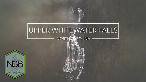
Upper Whitewater Falls is the highest waterfall east of the Rockies. The falls plunge an incredible 411 feet! It is easily the tallest waterfall in the Blue Ridge Mountains of North Carolina, in the Cashiers area of the Pisgah National Forest. These falls are frequently visited as there are many other waterfalls nearby. The trail itself was only .25 miles round trip. Upper Whitewater Falls was full of water since a rainstorm had moved through the area the day before. The path is pretty well-manicured, even paved in most places, and marked. There are plenty of stairs to utilize to get to the lookout platform, but you also get a decent view at the end of the paved walkway.
Instagram: https://www.instagram.com/nevergrowbored
Vero: https://vero.co/nevergrowbored
My Photo Site: https://seanhogan.smugmug.com/
My Hiking Blog: https://nevergrowbored.blogspot.com
Twitter: https://twitter.com/seanhogan410
FB Page: https://www.facebook.com/seanhogan410
LinkTree: https://beacons.ai/nevergrowbored
Patreon: https://www.patreon.com/nevergrowbored
My Hiking Spotify Playlist: https://open.spotify.com/playlist/4MIOHBaT4j5hdNtjRgEc1J?si=931c8f82b9114aff
Music Link: https://open.spotify.com/track/2ssp2O5R8rnNFlZU1BtAkI?si=b91ca97e884542d4
Google Map Location: https://goo.gl/maps/vmpDaUe7w7r9eEcf8
AllTrails Link: https://www.alltrails.com/trail/us/north-carolina/upper-whitewater-falls-trail--2
Electronic Equipment:
Trail App I use: https://www.alltrails.com
Drone I Use: https://store.dji.com/product/mavic-air-2
Handheld Gimbal I Use: https://www.dji.com/osmo-pocket
Sony A6400: shorturl.at/kwyT8
My Hiking Gear:
Boots: t.ly/qC2f
Daypack: t.ly/e3TH
Backpack: t.ly/CUTP
3P Tent: t.ly/bz4h
2P Tent: t.ly/jUhy
Hammock: t.ly/iIRz
Shorts (non-jorts): t.ly/dbFq
Socks: t.ly/MnOX
Shades: t.ly/LWSH
DJI Link to $10 Off Coupon: https://referral.dji.com/events/dji-referral/referrers/0f7ae30e-d8ad-492c-b24b-9e9004f9eb31/share
#upperwhitewaterfalls #ncwaterfall #waterfall #waterfalls #highlands #whitewaterfalls #pisgahnationalforest #waterfallhike #northcarolina #waterfallchasing
45
views

Upper Creek Falls, North Carolina -- 4K Cinematic
Upper Creek Falls is a pretty famous waterfall that is also VERY dangerous. We visited during a huge rainstorm and it was amazing! Upper River Falls is tucked into the Blue Ridge Mountains of North Carolina, near Elk Park North Carolina. The trail itself was only 1.5 miles round trip in a loop. Upper Creek Falls was pumped full of water since a rainstorm had moved through the area only days before and it was even raining during most of this video. If you make the loop, this trail is well-worn and has many steep sections. There is a very quick descent if you want to go to the base of the falls where I got most of the shots. There are two creek crossings, so if you are not a fan of getting a bit wet, this may not be the hike for you.
There was also a TON of rain coming down, so the drone had to remain dry. I had already flown it at Elk River Falls on this day and it was wet, so for fear of ruining it, I decided to keep it safe. Please wear proper hiking shoes, bring a friend, and download a trail map. Exercise Caution! AT YOUR OWN RISK!
Instagram: https://www.instagram.com/nevergrowbored
Vero: https://vero.co/nevergrowbored
My Photo Site: https://seanhogan.smugmug.com/
My Hiking Blog: https://nevergrowbored.blogspot.com
Twitter: https://twitter.com/seanhogan410
FB Page: https://www.facebook.com/seanhogan410
LinkTree: https://beacons.ai/nevergrowbored
Patreon: https://www.patreon.com/nevergrowbored
My Hiking Spotify Playlist: https://open.spotify.com/playlist/4MIOHBaT4j5hdNtjRgEc1J?si=931c8f82b9114aff
Music Link: https://open.spotify.com/album/5GT7HpvzBkLm3K3l1NNYoM?si=zBS54cKvSlaP9puajME-Jg
Google Map Location: https://goo.gl/maps/BsFpmQayN9H9tmAN7
AllTrails Link: https://www.alltrails.com/explore/trail/us/north-carolina/upper-creek-falls-loop-trail
Electronic Equipment:
Trail App I use: https://www.alltrails.com
Drone I Use: https://store.dji.com/product/mavic-air-2
Handheld Gimbal I Use: https://www.dji.com/osmo-pocket
Sony A6400: shorturl.at/kwyT8
My Hiking Gear:
Boots: t.ly/qC2f
Daypack: t.ly/e3TH
Backpack: t.ly/CUTP
3P Tent: t.ly/bz4h
2P Tent: t.ly/jUhy
Hammock: t.ly/iIRz
Shorts (non-jorts): t.ly/dbFq
Socks: t.ly/MnOX
Shades: t.ly/LWSH
DJI Link to $10 Off Coupon: https://referral.dji.com/events/dji-referral/referrers/0f7ae30e-d8ad-492c-b24b-9e9004f9eb31/share
#uppercreekfalls #ncwaterfall #waterfall #waterfalls #chasingwaterfalls #pisgahnationalforest #waterfallhike #northcarolina #waterfallchasing
24
views
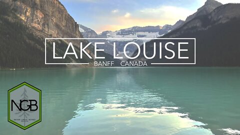
Lake Louise, Banff, Alberta -- 4K Cinematic
This 5.4 mile (8.7 km) hike begins at the Cave Basin & Historical Site in Banff National Park, Alberta. It wasn't terribly crowded, but since the first portion of the hike along the Bow River is paved, you will likely encounter several bikers and possibly horseback riders. The actual trail off the pavement can be a bit steep at times. The view at the Sundance Canyon Lookout is incredible so make sure to bring a camera. Keep an eye out for wildlife like bears, deer, and elk, as this is excellent habitat.
Amber & I choose this hike on our honeymoon specifically because there are fewer tourists and it was a great hike to get our legs broken in for the remainder of the week.
Bring Bear Spray. Exercise Caution! AT YOUR OWN RISK!
Our Banff/Yoho Itinerary: https://docs.google.com/document/d/15lLZRhOuUB30lAUP7SNqz2yVQrYOrm6pTq4qhblwG7U/edit?usp=sharing
Instagram: https://www.instagram.com/nevergrowbored
My Photo Site: https://seanhogan.smugmug.com/
My Hiking Blog: https://nevergrowbored.blogspot.com
FB Page: https://www.facebook.com/seanhogan410
Vero: https://vero.co/nevergrowbored
Twitter: https://twitter.com/seanhogan410
LinkTree: https://beacons.ai/nevergrowbored
Patreon: https://www.patreon.com/nevergrowbored
My Hiking Spotify Playlist: https://open.spotify.com/playlist/4MIOHBaT4j5hdNtjRgEc1J?si=931c8f82b9114aff
Music Link:
Google Map Location:
AllTrails Link:
Electronic Equipment:
Trail App I use: https://www.alltrails.com
Drone I Use: https://store.dji.com/product/mavic-air-2
Handheld Gimbal I Use: https://www.dji.com/osmo-pocket
Sony A6400: shorturl.at/kwyT8
My Hiking Gear:
Boots: t.ly/qC2f
Daypack: t.ly/e3TH
Backpack: t.ly/CUTP
3P Tent: t.ly/bz4h
2P Tent: t.ly/jUhy
Hammock: t.ly/iIRz
Shorts (non-jorts): t.ly/dbFq
Socks: t.ly/MnOX
Shades: t.ly/LWSH
DJI Link to $10 Off Coupon: https://referral.dji.com/events/dji-referral/referrers/0f7ae30e-d8ad-492c-b24b-9e9004f9eb31/share
#lakelouise #banffnationalpark #alberta #hike #banff #easyhike #banffnationalpark #beginnerfriendly #fairmountchateau
31
views
Elk River Falls, North Carolina -- 4K Cinematic
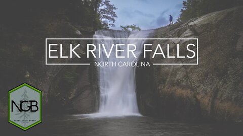
Elk River Falls is a very popular waterfall that is also VERY dangerous. We visited during a huge rainstorm and it was amazing! Elk River Falls is tucked into the Blue Ridge Mountains of North Carolina, near Elk Park North Carolina. The trail itself was only .5 miles round trip. Elk River Falls was pumped full of water since a rainstorm had moved through the area only days before and it was even raining during most of this video. This trail is pretty well-worn and flat, however, there is a quick descent if you want to go to the base of the falls.
A long-time popular swimming hole in the summer, its danger is masked by its beauty. Elk River Falls is large and powerful. Most deaths happen with people jumping off the top and plunging into the falls to only be caught in the undertow and held down. In the most recent death, the body did not resurface for almost an hour. Wear proper hiking shoes, bring a friend, and download a trail map. Exercise Caution! AT YOUR OWN RISK!
Instagram: https://www.instagram.com/nevergrowbored
Vero: https://vero.co/nevergrowbored
My Photo Site: https://seanhogan.smugmug.com/
My Hiking Blog: https://nevergrowbored.blogspot.com
Twitter: https://twitter.com/seanhogan410
FB Page: https://www.facebook.com/seanhogan410
LinkTree: https://beacons.ai/nevergrowbored
Patreon: https://www.patreon.com/nevergrowbored
My Hiking Spotify Playlist: https://open.spotify.com/playlist/4MIOHBaT4j5hdNtjRgEc1J?si=931c8f82b9114aff
Music Link: https://open.spotify.com/track/4VqTwYvxW9lsKQ6x11A50z?si=d172e35053b84336
Google Map Location: https://goo.gl/maps/pXAqumCDDgVqnpMQ7
AllTrails Link: https://www.alltrails.com/trail/us/north-carolina/elk-river-falls-trail
Electronic Equipment:
Trail App I use: https://www.alltrails.com
Drone I Use: https://store.dji.com/product/mavic-air-2
Handheld Gimbal I Use: https://www.dji.com/osmo-pocket
Sony A6400: shorturl.at/kwyT8
My Hiking Gear:
Boots: t.ly/qC2f
Daypack: t.ly/e3TH
Backpack: t.ly/CUTP
3P Tent: t.ly/bz4h
2P Tent: t.ly/jUhy
Hammock: t.ly/iIRz
Shorts (non-jorts): t.ly/dbFq
Socks: t.ly/MnOX
Shades: t.ly/LWSH
DJI Link to $10 Off Coupon: https://referral.dji.com/events/dji-referral/referrers/0f7ae30e-d8ad-492c-b24b-9e9004f9eb31/share
#tomscreekfalls #ncwaterfall #waterfall #waterfalls #tomscreek #linville #pisgahnationalforest #waterfallhike #northcarolina #waterfallchasing
37
views
Toms Creek Falls, North Carolina -- 4K Cinematic
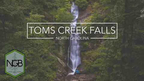
Toms Creek Falls is a tall waterfall that is seldomly full. However, after recent rains, we visited and it was amazing! Toms Creek Falls is tucked into the Blue Ridge Mountains of North Carolina, near Marion close to the Linville Gorge area. The trail itself was only .5 miles round trip. Toms Creek Falls was pumped full of water since a rainstorm had moved through the area only days before and it was even raining during most of this video. This trail is pretty well-worn and overall relatively flat. Wear proper hiking shoes, bring a friend and download a trail map. Exercise Caution! AT YOUR OWN RISK!
Instagram: https://www.instagram.com/nevergrowbored
Vero: https://vero.co/nevergrowbored
My Photo Site: https://seanhogan.smugmug.com/
My Hiking Blog: https://nevergrowbored.blogspot.com
Twitter: https://twitter.com/seanhogan410
FB Page: https://www.facebook.com/seanhogan410
LinkTree: https://beacons.ai/nevergrowbored
Patreon: https://www.patreon.com/nevergrowbored
My Hiking Spotify Playlist: https://open.spotify.com/playlist/4MIOHBaT4j5hdNtjRgEc1J?si=931c8f82b9114aff
Music Link: https://open.spotify.com/track/4KMOevw12On2mtMXiHsF4N?si=20535dd3c4244ea4
Google Map Location: https://goo.gl/maps/Z5exsA7HTft23XuHA
AllTrails Link: https://www.alltrails.com/trail/us/north-carolina/toms-creek-falls-trail
Electronic Equipment:
Trail App I use: https://www.alltrails.com
Drone I Use: https://store.dji.com/product/mavic-air-2
Handheld Gimbal I Use: https://www.dji.com/osmo-pocket
Sony A6400: shorturl.at/kwyT8
My Hiking Gear:
Boots: t.ly/qC2f
Daypack: t.ly/e3TH
Backpack: t.ly/CUTP
3P Tent: t.ly/bz4h
2P Tent: t.ly/jUhy
Hammock: t.ly/iIRz
Shorts (non-jorts): t.ly/dbFq
Socks: t.ly/MnOX
Shades: t.ly/LWSH
DJI Link to $10 Off Coupon: https://referral.dji.com/events/dji-referral/referrers/0f7ae30e-d8ad-492c-b24b-9e9004f9eb31/share
#tomscreekfalls #ncwaterfall #waterfall #waterfalls #tomscreek #linville #pisgahnationalforest #waterfallhike #northcarolina #waterfallchasing
24
views
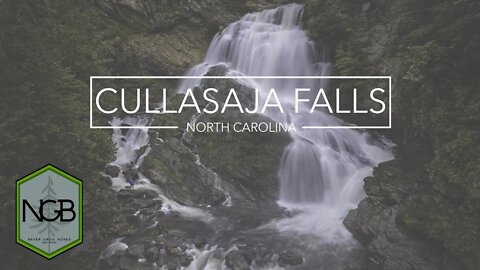
Cullajasa Falls, North Carolina -- 4K Cinematic
Cullajasa Falls is HUGE and must-visit waterfall in the Blue Ridge Mountains of North Carolina, in the Highlands area of the Nantahala National Forest. These falls are infrequently visited since there are many other roadside waterfalls nearby. The trail itself was only .5 miles round trip. Cullajasa Falls was pumped full of water since a rainstorm had moved through the area only days before and it was even raining during most of this video. Apparently, there is a new trail being built so more people can access these falls safer. The current "old" trail is steep, has loose gravel and mud, and can be quite perilous with a misstep. As always, wear proper hiking shoes, bring a friend and download a trail map. Exercise Caution! AT YOUR OWN RISK!
Instagram: https://www.instagram.com/nevergrowbored
Vero: https://vero.co/nevergrowbored
My Photo Site: https://seanhogan.smugmug.com/
My Hiking Blog: https://nevergrowbored.blogspot.com
Twitter: https://twitter.com/seanhogan410
FB Page: https://www.facebook.com/seanhogan410
LinkTree: https://beacons.ai/nevergrowbored
Patreon: https://www.patreon.com/nevergrowbored
My Hiking Spotify Playlist: https://open.spotify.com/playlist/4MIOHBaT4j5hdNtjRgEc1J?si=931c8f82b9114aff
Music Link: https://open.spotify.com/track/2hlz2lZJXMDCe8x1Xn2AzJ?si=f0acfc0534394f90
Google Map Location: https://goo.gl/maps/31BP2dcJytzae3ph6
AllTrails Link: https://www.alltrails.com/trail/us/north-carolina/cullasaja-falls
Electronic Equipment:
Trail App I use: https://www.alltrails.com
Drone I Use: https://store.dji.com/product/mavic-air-2
Handheld Gimbal I Use: https://www.dji.com/osmo-pocket
Sony A6400: shorturl.at/kwyT8
My Hiking Gear:
Boots: t.ly/qC2f
Daypack: t.ly/e3TH
Backpack: t.ly/CUTP
3P Tent: t.ly/bz4h
2P Tent: t.ly/jUhy
Hammock: t.ly/iIRz
Shorts (non-jorts): t.ly/dbFq
Socks: t.ly/MnOX
Shades: t.ly/LWSH
DJI Link to $10 Off Coupon: https://referral.dji.com/events/dji-referral/referrers/0f7ae30e-d8ad-492c-b24b-9e9004f9eb31/share
#cullasajafalls #ncwaterfall #waterfall #waterfalls #cullasajagorge #nantahala #pisgahnationalforest #waterfallhike #northcarolina #waterfallchasing
15
views
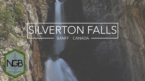
Silverton Falls, Banff National Park, Alberta -- 4K Cinematic
This 1.2 mile (2 km) RT hike begins at the Round Lake trailhead beside the highway in Banff National Park, Alberta. It doesn’t get the crowds that other hikes in Banff get, was it better signed. Silverton Falls is a breathtaking waterfall surrounded by a granite wall on both sides. It plunges into a decent pool at the base of the falls. Getting there takes a gentle uphill stroll through the thick conifer forest. The tree density lessens somewhat as you near the falls, and you’ll hear the falls booming.
Amber & I choose this hike on our honeymoon specifically because there are fewer tourists and you don't have to fight for the path. We visited Johnston Caynon prior to this and found it too busy for our liking. It's only a short drive from Banff or Canmore, but well worth it!
Bring Bear Spray. Exercise Caution! AT YOUR OWN RISK!
Our Banff/Yoho Itinerary: https://docs.google.com/document/d/15lLZRhOuUB30lAUP7SNqz2yVQrYOrm6pTq4qhblwG7U/edit?usp=sharing
Instagram: https://www.instagram.com/nevergrowbored
My Photo Site: https://seanhogan.smugmug.com/
My Hiking Blog: https://nevergrowbored.blogspot.com
FB Page: https://www.facebook.com/seanhogan410
Vero: https://vero.co/nevergrowbored
Twitter: https://twitter.com/seanhogan410
LinkTree: https://beacons.ai/nevergrowbored
Patreon: https://www.patreon.com/nevergrowbored
My Hiking Spotify Playlist: https://open.spotify.com/playlist/4MIOHBaT4j5hdNtjRgEc1J?si=931c8f82b9114aff
Music Link: https://open.spotify.com/track/6TxeD6qqjaDHEAfVMcvnw4?si=16d48df63ad04168
Google Map Location: https://goo.gl/maps/vDPXAcs957kJa6838
AllTrails Link: https://www.alltrails.com/trail/canada/alberta/silverton-falls?u=i
Electronic Equipment:
Trail App I use: https://www.alltrails.com
Drone I Use: https://store.dji.com/product/mavic-air-2
Handheld Gimbal I Use: https://www.dji.com/osmo-pocket
Sony A6400: shorturl.at/kwyT8
My Hiking Gear:
Boots: t.ly/qC2f
Daypack: t.ly/e3TH
Backpack: t.ly/CUTP
3P Tent: t.ly/bz4h
2P Tent: t.ly/jUhy
Hammock: t.ly/iIRz
Shorts (non-jorts): t.ly/dbFq
Socks: t.ly/MnOX
Shades: t.ly/LWSH
DJI Link to $10 Off Coupon: https://referral.dji.com/events/dji-referral/referrers/0f7ae30e-d8ad-492c-b24b-9e9004f9eb31/share
#silvertonfalls #banffnationalpark #alberta #hike #banff #bowriver #banffwaterfall #waterfallhike #roundlake #easyhike
28
views
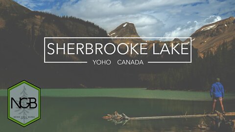
Sherbrooke Lake, Yoho National Park, BC -- 4K Cinematic
This 3.7 mile (6 km) hike begins at a rather unassuming trailhead beside the highway across from Wapta Lake in Yoho National Park, British Columbia. It doesn’t get the crowds that other hikes in Yoho get, were it better signed. Sherbrooke Lake is a rather sizeable alpine lake tucked into a narrow and steep valley. Getting there takes a gentle uphill stroll through the thick conifer forest. The tree density lessens somewhat as you near the lake, and you’ll hear the creek rushing downhill nearby as you glimpse peaks rising above. Keep an eye out for wildlife like deer and elk, as this is excellent habitat.
Once at the lake, the scale of the landscape becomes really apparent. Across the water, on the other side, the near-vertical cliffs of Mount Ogden form a jagged skyline, and beyond the lake, farther up the valley, even taller peaks make the backdrop. The valley at the lake is surrounded by peaks and streaked by avalanche paths. Take some time to explore the lakeshore, noting the places where massive avalanches have brought debris right down to the water
Amber & I choose this hike on our honeymoon specifically because there are fewer tourists and you don't have to fight for the path. Our "Yoho Day" was likely our favorite while visiting Canada. It's only a short drive from Banff or Canmore, but well worth it! There are plenty of other sites nearby in Yoho National Park, including Takakkaw Falls, Emerald Lake, Hamilton Falls, the Natural Bridge, Spiral Tunnels, and the Rivers Confluence to name a few.
Bring Bear Spray. Exercise Caution! AT YOUR OWN RISK!
Our Banff/Yoho Itinerary: https://docs.google.com/document/d/15lLZRhOuUB30lAUP7SNqz2yVQrYOrm6pTq4qhblwG7U/edit?usp=sharing
Instagram: https://www.instagram.com/nevergrowbored
My Photo Site: https://seanhogan.smugmug.com/
My Hiking Blog: https://nevergrowbored.blogspot.com
FB Page: https://www.facebook.com/seanhogan410
Vero: https://vero.co/nevergrowbored
Twitter: https://twitter.com/seanhogan410
LinkTree: https://beacons.ai/nevergrowbored
Patreon: https://www.patreon.com/nevergrowbored
My Hiking Spotify Playlist: https://open.spotify.com/playlist/4MIOHBaT4j5hdNtjRgEc1J?si=931c8f82b9114aff
Music Link: https://open.spotify.com/track/3CkWkWAhZii9OWuQJw0NTe?si=be789e3dd43e43a6
Google Map Location: https://goo.gl/maps/Eqx4au4TyJ12wYMV8
AllTrails Link: https://www.alltrails.com/trail/canada/british-columbia/sherbrooke-lake?u=i
Electronic Equipment:
Trail App I use: https://www.alltrails.com
Drone I Use: https://store.dji.com/product/mavic-air-2
Handheld Gimbal I Use: https://www.dji.com/osmo-pocket
Sony A6400: shorturl.at/kwyT8
My Hiking Gear:
Boots: t.ly/qC2f
Daypack: t.ly/e3TH
Backpack: t.ly/CUTP
3P Tent: t.ly/bz4h
2P Tent: t.ly/jUhy
Hammock: t.ly/iIRz
Shorts (non-jorts): t.ly/dbFq
Socks: t.ly/MnOX
Shades: t.ly/LWSH
DJI Link to $10 Off Coupon: https://referral.dji.com/events/dji-referral/referrers/0f7ae30e-d8ad-492c-b24b-9e9004f9eb31/share
#sherbrookelake #yohonationalpark #britishcolumbia #hike #yoho #lakehike #banff #waterfallhike #banffnationalpark #mountainlake
27
views
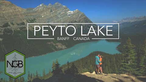
Peyto Lake, Banff National Park, Alberta -- 4K Cinematic
Peyto Lake is an easy 1.5-mile trail near Lake Louise, Alberta in Banff National Park. Generally considered an easy route, it takes an average of 43 min to complete. This is a very popular area for hiking, so you'll likely encounter other people while exploring. The panoramic lookout is insanely beautiful!
Amber & I choose this hike on our honeymoon for its beauty and splendor. It's a very busy pitstop and there is plenty of space for everyone to snap a few photos. It's only a short drive from Banff or Lake Louise, but well worth it!
Bring Bear Spray. Exercise Caution! AT YOUR OWN RISK!
Our Banff/Yoho Itinerary: https://docs.google.com/document/d/15lLZRhOuUB30lAUP7SNqz2yVQrYOrm6pTq4qhblwG7U/edit?usp=sharing
Instagram: https://www.instagram.com/nevergrowbored
My Photo Site: https://seanhogan.smugmug.com/
My Hiking Blog: https://nevergrowbored.blogspot.com
FB Page: https://www.facebook.com/seanhogan410
Vero: https://vero.co/nevergrowbored
Twitter: https://twitter.com/seanhogan410
LinkTree: https://beacons.ai/nevergrowbored
Patreon: https://www.patreon.com/nevergrowbored
My Hiking Spotify Playlist: https://open.spotify.com/playlist/4MIOHBaT4j5hdNtjRgEc1J?si=931c8f82b9114aff
Music Link: https://open.spotify.com/track/54iMHNHJpXhx0AHXNoAwPz?si=154db328c3694aa6
Google Map Location: https://goo.gl/maps/1rGqntG5TSJ2ZTJz5
AllTrails Link: https://www.alltrails.com/trail/canada/alberta/peyto-lake-panorama-overlook?u=i
Electronic Equipment:
Trail App I use: https://www.alltrails.com
Drone I Use: https://store.dji.com/product/mavic-air-2
Handheld Gimbal I Use: https://www.dji.com/osmo-pocket
Sony A6400: shorturl.at/kwyT8
My Hiking Gear:
Boots: t.ly/qC2f
Daypack: t.ly/e3TH
Backpack: t.ly/CUTP
3P Tent: t.ly/bz4h
2P Tent: t.ly/jUhy
Hammock: t.ly/iIRz
Shorts (non-jorts): t.ly/dbFq
Socks: t.ly/MnOX
Shades: t.ly/LWSH
DJI Link to $10 Off Coupon: https://referral.dji.com/events/dji-referral/referrers/0f7ae30e-d8ad-492c-b24b-9e9004f9eb31/share
#peytolake #banffnationalpark #alberta #hike #banff #peytolakehike #banfflake #waterfallhike #roundlake #easyhike
19
views
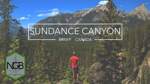
Sundance Canyon, Banff National Park, Alberta -- 4K Cinematic
This 5.4 mile (8.7 km) hike begins at the Cave Basin & Historical Site in Banff National Park, Alberta. It wasn't terribly crowded, but since the first portion of the hike along the Bow River is paved, you will likely encounter several bikers and possibly horseback riders. The actual trail off the pavement can be a bit steep at times. The view at the Sundance Canyon Lookout is incredible so make sure to bring a camera. Keep an eye out for wildlife like bears, deer, and elk, as this is excellent habitat.
Amber & I choose this hike on our honeymoon specifically because there are fewer tourists and it was a great hike to get our legs broken in for the remainder of the week.
Bring Bear Spray. Exercise Caution! AT YOUR OWN RISK!
Our Banff/Yoho Itinerary: https://docs.google.com/document/d/15lLZRhOuUB30lAUP7SNqz2yVQrYOrm6pTq4qhblwG7U/edit?usp=sharing
Instagram: https://www.instagram.com/nevergrowbored
My Photo Site: https://seanhogan.smugmug.com/
My Hiking Blog: https://nevergrowbored.blogspot.com
FB Page: https://www.facebook.com/seanhogan410
Vero: https://vero.co/nevergrowbored
Twitter: https://twitter.com/seanhogan410
LinkTree: https://beacons.ai/nevergrowbored
Patreon: https://www.patreon.com/nevergrowbored
My Hiking Spotify Playlist: https://open.spotify.com/playlist/4MIOHBaT4j5hdNtjRgEc1J?si=931c8f82b9114aff
Music Link: https://soundcloud.com/matthew-heyer-official/novo-amor-weather-matthew-heyer-remix
Google Map Location: https://goo.gl/maps/NRUh6CVrHtBiSBMA8
AllTrails Link: https://www.alltrails.com/trail/canada/alberta/sundance-canyon-trail--2?p=-1&u=i
Electronic Equipment:
Trail App I use: https://www.alltrails.com
Drone I Use: https://store.dji.com/product/mavic-air-2
Handheld Gimbal I Use: https://www.dji.com/osmo-pocket
Sony A6400: shorturl.at/kwyT8
My Hiking Gear:
Boots: t.ly/qC2f
Daypack: t.ly/e3TH
Backpack: t.ly/CUTP
3P Tent: t.ly/bz4h
2P Tent: t.ly/jUhy
Hammock: t.ly/iIRz
Shorts (non-jorts): t.ly/dbFq
Socks: t.ly/MnOX
Shades: t.ly/LWSH
DJI Link to $10 Off Coupon: https://referral.dji.com/events/dji-referral/referrers/0f7ae30e-d8ad-492c-b24b-9e9004f9eb31/share
#sundancecanyon #banffnationalpark #alberta #hike #banff #bowriver #sundancecayonlookout #easyhike #banffnationalpark #beginnerfriendly
31
views
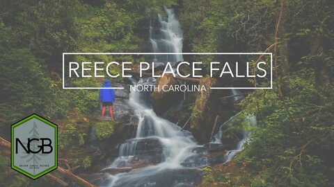
Reece Place Falls, North Carolina -- 4K Cinematic
Reece Place Falls is an excellent lesser-known waterfall in the Blue Ridge Mountains of North Carolina, in the Headwaters State Forest near the town of Eastatoe. These falls are infrequently visited since there are many other roadside waterfalls nearby. The trail itself was only 2.1 miles round trip. Reece Place Falls was decently full of water since a rain storm had moved through the area only days before. As always, wear proper hiking shoes, bring a friend and download a trail map. Exercise Caution! AT YOUR OWN RISK!
Instagram: https://www.instagram.com/nevergrowbored
My Photo Site: https://seanhogan.smugmug.com/
My Hiking Blog: https://nevergrowbored.blogspot.com
Twitter: https://twitter.com/seanhogan410
FB Page: https://www.facebook.com/seanhogan410
LinkTree: https://beacons.ai/nevergrowbored
Patreon: https://www.patreon.com/nevergrowbored
My Hiking Spotify Playlist: https://open.spotify.com/playlist/4MIOHBaT4j5hdNtjRgEc1J?si=931c8f82b9114aff
Music Link: https://open.spotify.com/track/7EdE1Ki7I2vhQGxs2DAgmD?si=7af8d11d0e0a463b
Google Map Location: https://goo.gl/maps/xmbYY2qhPdkAg37L8
AllTrails Link: https://www.alltrails.com/trail/us/north-carolina/reece-place-falls
Electronic Equipment:
Trail App I use: https://www.alltrails.com
Drone I Use: https://store.dji.com/product/mavic-air-2
Handheld Gimbal I Use: https://www.dji.com/osmo-pocket
Sony A6400: shorturl.at/kwyT8
My Hiking Gear:
Boots: t.ly/qC2f
Daypack: t.ly/e3TH
Backpack: t.ly/CUTP
3P Tent: t.ly/bz4h
2P Tent: t.ly/jUhy
Hammock: t.ly/iIRz
Shorts (non-jorts): t.ly/dbFq
Socks: t.ly/MnOX
Shades: t.ly/LWSH
DJI Link to $10 Off Coupon: https://referral.dji.com/events/dji-referral/referrers/0f7ae30e-d8ad-492c-b24b-9e9004f9eb31/share
#reeceplacefalls #ncwaterfall #waterfall #waterfalls #headwatersstateforest #nantahala #pisgahnationalforest #waterfallhike #northcarolina #waterfallchasing
59
views
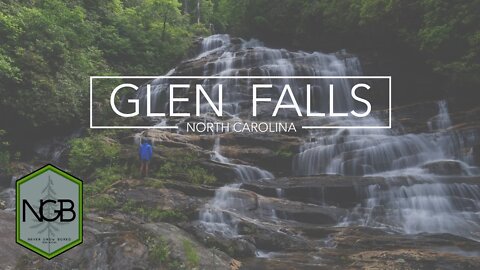
Glen Falls, North Carolina -- 4K Cinematic
Glen Falls is an excellent popular waterfall in the Blue Ridge Mountains of North Carolina, in the Pisgah National Forest just outside of the Highlands. These falls are frequently visited since there are many other roadside waterfalls nearby and this hike is well manicured for most visitors. The trail itself was only 2.4 miles round trip. Glen Falls was decently full of water since a rain storm had moved through the area only days before. As always, wear proper hiking shoes, bring a friend and download a trail map. Exercise Caution! AT YOUR OWN RISK!
Instagram: https://www.instagram.com/nevergrowbored
My Photo Site: https://seanhogan.smugmug.com/
My Hiking Blog: https://nevergrowbored.blogspot.com
Twitter: https://twitter.com/seanhogan410
FB Page: https://www.facebook.com/seanhogan410
LinkTree: https://beacons.ai/nevergrowbored
Patreon: https://www.patreon.com/nevergrowbored
My Hiking Spotify Playlist: https://open.spotify.com/playlist/4MIOHBaT4j5hdNtjRgEc1J?si=931c8f82b9114aff
Music Link: https://open.spotify.com/track/7Exe0mVrJblSNEiRuBI96A?si=810159e880e94590
Google Map Location: https://goo.gl/maps/QhEDbd3tu8oNvNmC6
AllTrails Link: https://www.alltrails.com/trail/us/north-carolina/glen-falls-trail
Electronic Equipment:
Trail App I use: https://www.alltrails.com
Drone I Use: https://store.dji.com/product/mavic-air-2
Handheld Gimbal I Use: https://www.dji.com/osmo-pocket
Sony A6400: shorturl.at/kwyT8
My Hiking Gear:
Boots: t.ly/qC2f
Daypack: t.ly/e3TH
Backpack: t.ly/CUTP
3P Tent: t.ly/bz4h
2P Tent: t.ly/jUhy
Hammock: t.ly/iIRz
Shorts (non-jorts): t.ly/dbFq
Socks: t.ly/MnOX
Shades: t.ly/LWSH
DJI Link to $10 Off Coupon: https://referral.dji.com/events/dji-referral/referrers/0f7ae30e-d8ad-492c-b24b-9e9004f9eb31/share
#reeceplacefalls #ncwaterfall #waterfall #waterfalls #headwatersstateforest #nantahala #pisgahnationalforest #waterfallhike #northcarolina #waterfallchasing
51
views


Dry Falls, North Carolina -- 4K Cinematic
Dry Falls is an absolutely stunning waterfall in the Blue Ridge Mountains of North Carolina, in the Nantahala National Forest near Highlands. These falls are frequently visited since its very close to the side of Route 64, Highland Rd. The trail itself was only a few 100 yds round trip. Dry Falls was decently full of water since a rain storm had moved through the area only days before. As always, wear proper hiking shoes, bring a friend and download a trail map. Exercise Caution! The falls themselves are gorgeous and extremely tall! AT YOUR OWN RISK!
Instagram: https://www.instagram.com/nevergrowbored
My Photo Site: https://seanhogan.smugmug.com/
My Hiking Blog: https://nevergrowbored.blogspot.com
Twitter: https://twitter.com/seanhogan410
FB Page: https://www.facebook.com/seanhogan410
LinkTree: https://beacons.ai/nevergrowbored
Patreon: https://www.patreon.com/nevergrowbored
My Hiking Spotify Playlist: https://open.spotify.com/playlist/4MIOHBaT4j5hdNtjRgEc1J?si=931c8f82b9114aff
Music Link: https://soundcloud.com/attommusicofficial/shibui
Google Map Location: https://goo.gl/maps/wbKeKuGxk55FghjR8
AllTrails Link: https://www.alltrails.com/trail/us/north-carolina/dry-falls-trail
Electronic Equipment:
Trail App I use: https://www.alltrails.com
Drone I Use: https://store.dji.com/product/mavic-air-2
Handheld Gimbal I Use: https://www.dji.com/osmo-pocket
Sony A6400: shorturl.at/kwyT8
My Hiking Gear:
Boots: t.ly/qC2f
Daypack: t.ly/e3TH
Backpack: t.ly/CUTP
3P Tent: t.ly/bz4h
2P Tent: t.ly/jUhy
Hammock: t.ly/iIRz
Shorts (non-jorts): t.ly/dbFq
Socks: t.ly/MnOX
Shades: t.ly/LWSH
DJI Link to $10 Off Coupon: https://referral.dji.com/events/dji-referral/referrers/0f7ae30e-d8ad-492c-b24b-9e9004f9eb31/share
#dryfalls #ncwaterfall #waterfall #waterfalls #dryfallswaterfall #nantahala #pisgahnationalforest #waterfallhike #northcarolina #waterfallchasing #highlands
20
views
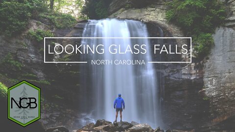
Looking Glass Falls, North Carolina -- 4K Cinematic
Looking Glass Falls is an absolutely stunning waterfall in the Blue Ridge Mountains of North Carolina, in the Nantahala National Forest near Brevard. These falls are frequently visited since it's very close to several other popular spots, including Sliding Rock & Moore Cove Falls. The trail itself was only a 100 yds or so round trip. Looking Glass Falls was decently full of water since a rain storm had moved through the area only days before. If you would like to also photograph or video the falls in detail, I would recommend getting there VERY early or almost sunset. Looking Glass Falls boasts a nice swimming hole which is another reason it's a popular tourist stop. As always, wear proper hiking shoes, bring a friend and download a trail map. Exercise Caution! The falls themselves are gorgeous and extremely tall! AT YOUR OWN RISK!
Instagram: https://www.instagram.com/nevergrowbored
My Photo Site: https://seanhogan.smugmug.com/
My Hiking Blog: https://nevergrowbored.blogspot.com
Twitter: https://twitter.com/seanhogan410
FB Page: https://www.facebook.com/seanhogan410
LinkTree: https://beacons.ai/nevergrowbored
My Hiking Spotify Playlist: https://open.spotify.com/playlist/4MIOHBaT4j5hdNtjRgEc1J?si=931c8f82b9114aff
Music Link: https://open.spotify.com/track/6onDP5pnrrmbtju7VTNz55?si=271e337d4b1c40d9
Google Map Location: https://goo.gl/maps/2GpUiJRR9oGrYmHk6
AllTrails Link: https://www.alltrails.com/trail/us/north-carolina/looking-glass-waterfalls
Electronic Equipment:
Trail App I use: https://www.alltrails.com
Drone I Use: https://store.dji.com/product/mavic-air-2
Handheld Gimbal I Use: https://www.dji.com/osmo-pocket
Sony A6400: shorturl.at/kwyT8
My Hiking Gear:
Boots: t.ly/qC2f
Daypack: t.ly/e3TH
Backpack: t.ly/CUTP
3P Tent: t.ly/bz4h
2P Tent: t.ly/jUhy
Hammock: t.ly/iIRz
Shorts (non-jorts): t.ly/dbFq
Socks: t.ly/MnOX
Shades: t.ly/LWSH
DJI Link to $10 Off Coupon: https://referral.dji.com/events/dji-referral/referrers/0f7ae30e-d8ad-492c-b24b-9e9004f9eb31/share
#lookingglassfalls #ncwaterfall #waterfall #waterfalls #lookingglass #nantahala #pisgahnationalforest #waterfallhike #northcarolina #waterfallchasing #brevard
14
views
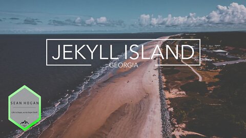
Jekyll Island Beach, Georgia -- 4K Cinematic
Jekyll Island is a beautiful ocean-facing beach on the Georgia coastline. It is rarely visited compared to many other popular southeast beaches (Jacksonville Beach, Myrtle, Hilton Head, Tybee Island, St. Simons, etc). Part of Jeyklls charm is the raw natural beach being that most of the island is under state park control. There are several great spots to visit on Jekyll Island. Most people also visit Driftwood Beach and Jeykll Island Resort. Jeykll Island is a favorite of ours and the kids have spent plenty of hours jumping waves and making memories. Jeykll is located only 90 miles from downtown Savannah and can easily be accessed on a normal day in a 90 min drive mostly down I-95. Jeykll Island is packed with history as it served as a playground for the uber-wealthy from the late 1800s to the mid-1900s. Still on the island are former homes of the Goodyear Family, Rockerfellers, Pulitzers, Fords, Dunlaps, JP Morgan, etc. They vacationed on Jekyll typically during the cold northern winter months.
Instagram: https://www.instagram.com/nevergrowbored
My Photo Site: https://seanhogan.smugmug.com/
My Hiking Blog: https://nevergrowbored.blogspot.com
Twitter: https://twitter.com/seanhogan410
FB Page: https://www.facebook.com/seanhogan410
LinkTree: https://beacons.ai/nevergrowbored
Music Link: https://soundcloud.com/lofifruitsmusic/lf718
Google Map Location: https://goo.gl/maps/1cSs1FjwU2MpvyiB6
Electronic Equipment:
Trail App I use: https://www.alltrails.com
Drone I Use: https://store.dji.com/product/mavic-air-2
Handheld Gimbal I Use: https://www.dji.com/osmo-pocket
My Hiking Gear:
Boots: t.ly/qC2f
Daypack: t.ly/e3TH
Backpack: t.ly/CUTP
3P Tent: t.ly/bz4h
2P Tent: t.ly/jUhy
Hammock: t.ly/iIRz
Shorts (non-jorts): t.ly/dbFq
Socks: t.ly/MnOX
Shades: t.ly/LWSH
DJI Link to $10 Off Coupon: https://referral.dji.com/events/dji-referral/referrers/0f7ae30e-d8ad-492c-b24b-9e9004f9eb31/share
#jekyllisland #jekyllislandbeach #jekyllbeach #georgiabeach #savannahga #savannah #jekyllislandga #tybeeislandlighthouse #georgia #georgiastateparks #stateparks
111
views
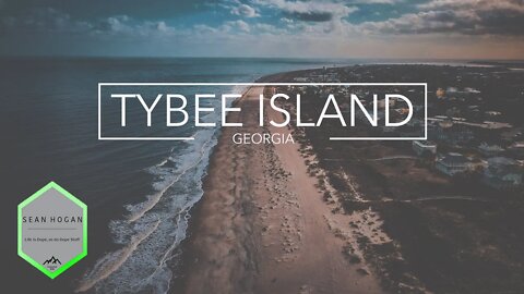
Tybee Island Beach, Georgia -- 4K Cinematic
Instagram: https://www.instagram.com/nevergrowbored
Twitter: https://twitter.com/seanhogan410
Music Link:
Trail App I use: https://www.alltrails.com
9
views
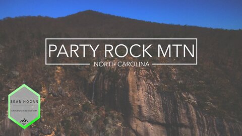
Party Rock Mountain, North Carolina -- 4K Cinematic
This Party Rock Mountain hike near Lake Lure, North Carolina was a short hike with moments of steep terrain, but still manageable and very well marked. This is a pretty vertical hike, but the reward is gorgeous from this great summit overlook! The trail itself was about 2.5 miles round trip and was a bit wet and slippery at the time we went. Party Rock summit had a massive waterfall at the time we went due to heavier than normal rains. I would NOT recommend trying to make it to the base of the falls. As always, wear proper hiking shoes, bring a friend and download a trail map. AT YOUR OWN RISK!
Instagram: https://www.instagram.com/nevergrowbored
My Photo Site: https://seanhogan.smugmug.com/
My Hiking Blog: https://nevergrowbored.blogspot.com
Twitter: https://twitter.com/seanhogan410
FB Page: https://www.facebook.com/seanhogan410
LinkTree: https://beacons.ai/nevergrowbored
Music Link: https://soundcloud.com/kidswaste/time
Google Map Location: https://goo.gl/maps/JQ5UTUwL7DMEaDu56
AllTrails Link: https://www.alltrails.com/trail/us/north-carolina/party-rock
Electronic Equipment:
Trail App I use: https://www.alltrails.com
Drone I Use: https://store.dji.com/product/mavic-air-2
Handheld Gimbal I Use: https://www.dji.com/osmo-pocket
My Hiking Gear:
Boots: t.ly/qC2f
Daypack: t.ly/e3TH
Backpack: t.ly/CUTP
3P Tent: t.ly/bz4h
2P Tent: t.ly/jUhy
Hammock: t.ly/iIRz
Shorts (non-jorts): t.ly/dbFq
Socks: t.ly/MnOX
Shades: t.ly/LWSH
DJI Link to $10 Off Coupon: https://referral.dji.com/events/dji-referral/referrers/0f7ae30e-d8ad-492c-b24b-9e9004f9eb31/share
#partyrock #partyrockmountain #chimneyrock #northcarolina #lakelure #lakelurenc #pisgahnationalforest #lakelurehike #chimneyrockhike #partyrocksummit #kraigadams

King & Queen Seats Hike, Maryland -- 4K Cinematic
This King and Queen Seats hike Rocks State Park near Bel Air, Maryland. It was a shorter hike, very manageable and well marked. Almost anyone can do this hike and the reward is gorgeous from this great summit overlook at King and Queen Seat! The trail itself was about 1.0 mile round trip, but you can also opt to do the loop making it a total of about 3.2 miles. The trail included several switchbacks, steps, and clearly marked blazes. King and Queen Seat had a great cloud view when we were on top and it was awesome to see the view! As always, wear proper hiking shoes, bring a friend and download a trail map. Exercise Caution! AT YOUR OWN RISK!
Instagram: https://www.instagram.com/nevergrowbored
My Photo Site: https://seanhogan.smugmug.com/
My Hiking Blog: https://nevergrowbored.blogspot.com
Twitter: https://twitter.com/seanhogan410
FB Page: https://www.facebook.com/seanhogan410
LinkTree: https://beacons.ai/nevergrowbored
Music Link: https://soundcloud.com/attommusicofficial/idyll
Google Map Location: https://goo.gl/maps/ivonL6wb2xVDxJLD6
AllTrails Link: https://www.alltrails.com/trail/us/maryland/king-and-queens-chair
Electronic Equipment:
Trail App I use: https://www.alltrails.com
Drone I Use: https://store.dji.com/product/mavic-air-2
Handheld Gimbal I Use: https://www.dji.com/osmo-pocket
My Hiking Gear:
Boots: t.ly/qC2f
Daypack: t.ly/e3TH
Backpack: t.ly/CUTP
3P Tent: t.ly/bz4h
2P Tent: t.ly/jUhy
Hammock: t.ly/iIRz
Shorts (non-jorts): t.ly/dbFq
Socks: t.ly/MnOX
Shades: t.ly/LWSH
DJI Link to $10 Off Coupon: https://referral.dji.com/events/dji-referral/referrers/0f7ae30e-d8ad-492c-b24b-9e9004f9eb31/share
#annapolisrock #appalaciantrail #maryland #marylandhike #annapolisrocks #overlook #AT #blueridgemountains #onlyinmaryland #annapolisrockhike
26
views

Annapolis Rock Hike, Maryland -- 4K Cinematic
This Annapolis Rock Overlook hike off of the Appalachian Trail near Hagerstown, Maryland. It was a shorter hike with moments of steep terrain, but still manageable and very well marked. Almost anyone can do this hike and the reward is gorgeous from this great summit overlook at Annapolis Rock! The trail itself was about 4.5 miles round trip, included several switchbacks, steps, and was a bit cloudy at the time we went. Annapolis Rock had great cloud play while we were on top of the mountain. As always, wear proper hiking shoes, bring a friend and download a trail map. Exercise Caution! AT YOUR OWN RISK!
Disclaimer: The Appalachian Trail has several drone No-Fly Zones (NFZ's). All drone footage was captured safely outside of any NFZ boundaries. All flying was done legally outside of the AT. For more on drone law maps, check out airmap.com
Instagram: https://www.instagram.com/nevergrowbored
My Photo Site: https://seanhogan.smugmug.com/
My Hiking Blog: https://nevergrowbored.blogspot.com
Twitter: https://twitter.com/seanhogan410
FB Page: https://www.facebook.com/seanhogan410
LinkTree: https://beacons.ai/nevergrowbored
Music Link: https://soundcloud.com/attommusicofficial/gradients
Google Map Location: https://goo.gl/maps/eD7oMy3Smyct2EJE8
AllTrails Link: https://www.alltrails.com/trail/us/maryland/annapolis-rock-via-appalachian-trail
Electronic Equipment:
Trail App I use: https://www.alltrails.com
Drone I Use: https://store.dji.com/product/mavic-air-2
Handheld Gimbal I Use: https://www.dji.com/osmo-pocket
My Hiking Gear:
Boots: t.ly/qC2f
Daypack: t.ly/e3TH
Backpack: t.ly/CUTP
3P Tent: t.ly/bz4h
2P Tent: t.ly/jUhy
Hammock: t.ly/iIRz
Shorts (non-jorts): t.ly/dbFq
Socks: t.ly/MnOX
Shades: t.ly/LWSH
DJI Link to $10 Off Coupon: https://referral.dji.com/events/dji-referral/referrers/0f7ae30e-d8ad-492c-b24b-9e9004f9eb31/share
#annapolisrock #appalaciantrail #maryland #marylandhike #annapolisrocks #overlook #AT #blueridgemountains #onlyinmaryland #annapolisrockhike
26
views