
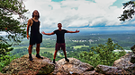
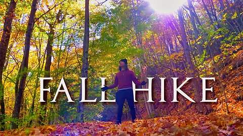
Stunning FALL FOLIAGE at Walden Creek & Bearden Falls
Any hike is better than not hiking. And any hike in autumn makes makes it better.
In this video, I hike in peak autumn-fall foliage to unpopular waterfall hikes; Walden Creek & Bearden Falls. Both are located in North, Georgia and I wanted to see if they were underrated.
Walden Creek Address
https://www.google.com/maps/dir//34.64596,-84.010529/@34.3340556,-84.5985164,10z/data=!4m5!4m4!1m0!1m1!4e1!3e0?entry=ttu
Bearden Falls Address
https://www.google.com/maps/dir//34.58902,-84.192199/@34.639314,-84.4549713,10.5z/data=!4m5!4m4!1m0!1m1!4e1!3e0?entry=ttu
EQUIPMENT WE USE: 🎥
Main Camera - https://amzn.to/3fTXmKf
GoPro– https://amzn.to/36LZl1z
Drone - https://amzn.to/3AZMzHq
Camera Shotgun Mic - https://amzn.to/39XVEar
Tony’s Backpack – 5.11 RUSH12 – https://amzn.to/3vZZpCd
Water Filter - https://amzn.to/3Ptp9Sd
MERCH:
https://www.redbubble.com/people/buildthedream/shop
GET IN CONTACT:
Email - buildthedream777@gmail.com
Website - https://buildthedreamnow.com
Support My Work - https://account.venmo.com/u/Tony-Hossri
Patreon - https://patreon.com/BuildTheDream?utm_medium=clipboard_copy&utm_source=copyLink&utm_campaign=creatorshare_creator&utm_content=join_link
_____________________________________________________________________________________________
Who are we?
We believe that life doesn't have to be the same day every day. You can Build The Dream life through exploration, travel, & adventure.
DISCLAIMER: This video and description contains affiliate links, which means that if you click on one of the product links, I’ll receive a small commission. This helps support the channel and allows us to continue to make videos like this. Thank you for the support!
#Autumn #fall #Hike #georgia #hiking #buildthedream #northgeorgia #fallfoliage #adventure #adventuresintoreality #nature #waterfall #explore #solohiker #solohike
60
views
1
comment
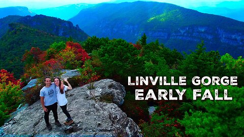
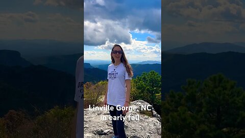
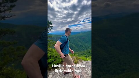
Hiking Camping LINVILLE GORGE in Early AUTUMN Fall | Tony & Heidi's Nature Adventures
In this video, my wife and I hike 2 EPIC trails in North Carolina's LINVILLE Gorge and then camp at Linville Falls RV and Cabins campsite.
The first hike is Table Rock which at a specific section of the summit, shows one of the best 360 views of Linville Gorge. However, it was rough going through the flies and bugs at the top, but worth it!
The next day we hiked Linville Falls waterfall trail where we witnessed two brave men jump from atop Linville Falls Waterfall! Enjoy!!
EQUIPMENT WE USE: 🎥
Main Camera - https://amzn.to/3fTXmKf
GoPro– https://amzn.to/36LZl1z
Drone - https://amzn.to/3AZMzHq
Camera Shotgun Mic - https://amzn.to/39XVEar
Tony’s Backpack – 5.11 RUSH12 – https://amzn.to/3vZZpCd
Water Filter - https://amzn.to/3Ptp9Sd
MERCH:
https://www.redbubble.com/people/buildthedream/shop
GET IN CONTACT:
Email - buildthedream777@gmail.com
Website - https://buildthedreamnow.com
Support My Work - https://account.venmo.com/u/Tony-Hossri
My Wife's YouTube Channel (Heidi Veronica) - https://www.youtube.com/@heidiveronica/videos
_____________________________________________________________________________________________
Table Rock is a mountain in the east rim of Linville Gorge, part of Pisgah National Forest (Grandfather Ranger District) in North Carolina. It features a distinctive rock formation, and is a prominent peak in the area.[2]
The peak makes for a quick hike from a nearby parking area, and is also very popular for rock climbing.[3] It is described as having a "national reputation of being the best place to climb in the Southeastern U.S.",[3] and the "hub of climbing activity in Linville Gorge".[4]
Table Rock is also known for its flora. Botanists André Michaux and John Fraser found various plants in the area in the nineteenth century. Fraser discovered Fraser's Sedge near the mountain.[3]
Table Rock has been described as "the most visible symbol in the region".[3] Former North Carolina senator Sam Ervin said that he retired to the nearby town of Morganton to "watch the glorious sunsets over Table Rock".[5] In addition, Jules Verne's novel Master of the World describes Table Rock, which is called Great Eyrie in the book, as "rising high above the valley to sometimes belch strange sounds and fire over the little village of Morganton".[3]
A wildfire swept through the area in November 2013. At least one hundred firefighters were involved.[6]
Linville Falls is a waterfall located in the Blue Ridge Mountains of North Carolina in the United States.[1] The falls move in several distinct steps, beginning in a twin set of upper falls, moving down a small gorge, and culminating in a high-volume 45-foot (14 m) drop.
It is named for the Linville River, which goes over the falls. Linville Falls has the highest volume of any waterfall on the Northern Edge of the Blue Ridge Mountains.[2]
Natural history
Linville Falls marks the beginning of the Linville Gorge, which is formed by the Linville River, which continues on after the falls before finally ending near Lake James.
At one time, the upper section of the main plunge was the same height as the lower section, however, flooding caused the upper section to collapse on top of the lower falls, making the lower falls a considerably longer plunge.[2]
https://en.wikipedia.org/wiki/Table_Rock_(North_Carolina)
Who are we?
We believe that life doesn't have to be the same day every day. You can Build The Dream life through exploration, travel, & adventure.
DISCLAIMER: This video and description contains affiliate links, which means that if you click on one of the product links, I’ll receive a small commission. This helps support the channel and allows us to continue to make videos like this. Thank you for the support!
#LinvilleGorge #camping #mountains #northcarolina #hiking #camp #buildthedream #besthikes #jumpingwaterfalls #hikingtrails #adventure #adventuresintoreality #mountain #waterfalljumping #explore #hikersparadise #northcarolina #hike #hikes
Timecodes
0:00 - Intro
0:16 - Hiking Table Rock
8:35 - Camping Linville Falls Campground RV Parks And Cabins
10:38 - Hiking Linville Falls Waterfall
13:32 - 2 Brave Men Jump Linville Falls Waterfall
16:13 - Hiking & Moral of the Story
124
views
1
comment
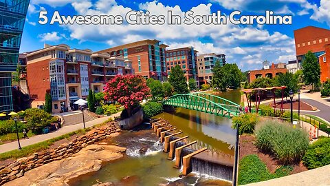
5 Awesome South Carolina Cities Worth a Visit
In this video, I break down 5 awesome cities in South Carolina that's worth a visit.
_____________________________________________________________________________________________
Merch:
http://www.redbubble.com/people/buildthedream
GET IN CONTACT:
Email - buildthedream777@gmail.com
Website - https://buildthedreamnow.com
SUPPORT MY WORK - https://account.venmo.com/u/Tony-Hossri
South Carolina (/ˌkærəˈlaɪnə/ (listen)) is a state in the coastal Southeastern region of the United States. It is bordered to the north by North Carolina, to the southeast by the Atlantic Ocean, and to the southwest by Georgia across the Savannah River. South Carolina is the 40th most extensive and 23rd most populous U.S. state with a recorded population of 5,124,712 according to the 2020 census.[5] In 2019, its GDP was $213.45 billion. South Carolina is composed of 46 counties. The capital is Columbia with a population of 137,300 in 2020;[6] while its largest city is Charleston with a 2020 population of 150,277.[7] The Greenville–Spartanburg-Anderson metropolitan area is the most populous in the state, with a 2020 population estimate of 1,455,892.[8]
Within South Carolina from east to west are three main geographic regions, the Atlantic coastal plain, the Piedmont, and the Blue Ridge Mountains in the northwestern corner of Upstate South Carolina. South Carolina has primarily a humid subtropical climate, with hot, humid summers and mild winters. Areas in the Upstate have a subtropical highland climate. Along South Carolina's eastern coastal plain are many salt marshes and estuaries. South Carolina's southeastern Lowcountry contains portions of the Sea Islands, a chain of barrier islands along the Atlantic Ocean.
https://en.wikipedia.org/wiki/South_Carolina
Who are we?
We believe that life doesn't have to be the same day every day. You can Build The Dream life through exploration, travel, & adventure.
DISCLAIMER: This video and description contains affiliate links, which means that if you click on one of the product links, I’ll receive a small commission. This helps support the channel and allows us to continue to make videos like this. Thank you for the support!
Myrtle Beach, Greenville, Charleston, Columbia, Folly Beach. Charleston, Hilton Head are the best vacation coastal cities in south Carolina!
#southcarolina #city #southcarolinacities #vacationspot
Timecodes
0:00 - Intro
0:08 - Myrtle Beach
1:00 - Greenville
1:42 - Charleston
2:33 - Columbia (Capital)
3:23 - Folly Beach
31
views
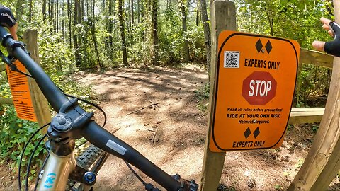
Downhill Mountain Biking Knuckle Sandwich | Expert II
In this video, I mountain bike a downhill trail with many jumps. Located in Allatoona Creek Park in the Bike Park section, I attempt Knuckle Sandwich Trail which is rated Expert Lv.2. However, I'm relatively new to mountain biking. So I do it much slower than the average mountain biker.
This MTB trail is in Acworth, Georgia located northwest of Atlanta. I highly recommend this area for mountain biking!
_____________________________________________________________________________________________
EQUIPMENT WE USE: 🎥
GoPro– https://amzn.to/36LZl1z
Merch:
https://www.redbubble.com/people/buildthedream/shop
GET IN CONTACT:
Email - buildthedream777@gmail.com
Website - https://buildthedreamnow.com
SUPPORT MY WORK - https://account.venmo.com/u/Tony-Hossri
Who are we?
We believe that life doesn't have to be the same day every day. You can Build The Dream life through exploration, travel, & adventure.
DISCLAIMER: This video and description contains affiliate links, which means that if you click on one of the product links, I’ll receive a small commission. This helps support the channel and allows us to continue to make videos like this. Thank you for the support!
#mountainbike #MTB #Outdoors #Georgia #mountainbiking #mountainbikinglife #trails #active
17
views
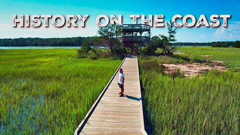
Best Hiking Trail Near Savannah, GA | Big Ferry Trail
In this video, I hike the Big Ferry Trail located near Savannah, Georgia on Skidaway Island. Not only is this coastal hike in a maritime forest considered one of Georgia's top ten hikes in the state, but also has 3 neat landmarks of American history.
On the trail, you'll find plenty of gorgeous Spanish moss, the Alligator pond, the shell midden used by native Americans, the observation tower where the historic road leading to the Savannah ferry was located, historic moonshine stills from the prohibition era, and civil war earthworks.
EQUIPMENT WE USE: 🎥
Main Camera - https://amzn.to/3fTXmKf
Drone - https://amzn.to/3AZMzHq
Camera Shotgun Mic - https://amzn.to/39XVEar
Tony’s Backpack – 5.11 RUSH12 – https://amzn.to/3vZZpCd
Water Filter - https://amzn.to/3Ptp9Sd
MERCH:
https://www.redbubble.com/people/buildthedream/shop
GET IN CONTACT:
Email - buildthedream777@gmail.com
Website - https://buildthedreamnow.com
Support My Work - https://account.venmo.com/u/Tony-Hossri
_____________________________________________________________________________________________
Who are we?
We believe that life doesn't have to be the same day every day. You can Build The Dream life through exploration, travel, & adventure.
DISCLAIMER: This video and description contains affiliate links, which means that if you click on one of the product links, I’ll receive a small commission. This helps support the channel and allows us to continue to make videos like this. Thank you for the support!
#savannah #history #Hiking #prohibition #abandonedplaces #ruins #Hike #georgia #buildthedream #Coast #hikingtrails #adventure #adventuresintoreality #explore #solohiker #solohike
22
views
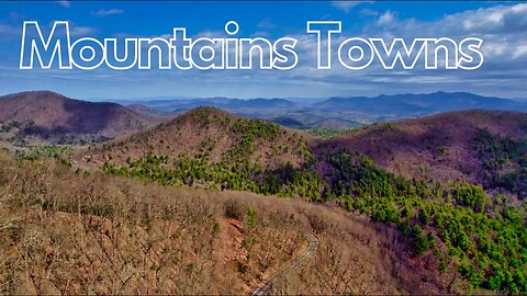
Top 7 Mountain Towns in Georgia, USA
I've traveled to every city in Georgia, USA. That being said, in this video, I narrowed it down to the top 7 best mountain towns in GA. I summarize why there all good in there own way!
_____________________________________________________________________________________________
Merch:
https://www.redbubble.com/people/buildthedream/shop
GET IN CONTACT:
Email - buildthedream777@gmail.com
Website - https://buildthedreamnow.com
SUPPORT MY WORK - https://account.venmo.com/u/Tony-Hossri
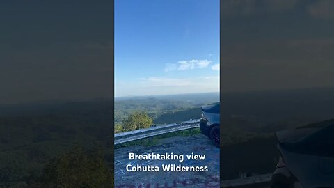
The Georgia Mountains Region or North Georgia mountains or Northeast Georgia is an area that starts in the northeast corner of Georgia, United States, and spreads in a westerly direction. The mountains in this region are in the Blue Ridge mountain chain that ends in Georgia. At over 1 billion years of age, the Blue Ridge mountains are among the oldest mountains in the United States and sometimes mistaken to be the oldest mountains in the world (they are only about one third of the age of South Africa's 3.6 billion year old Barberton greenstone belt.). The mountains in this region are also a part of the vast system of North American mountains known as the Appalachian Mountains that spans most of the United States longitudally along the eastern areas of the nation and terminates in Alabama.
The region is known for its ruggedness and scenic beauty. The Cherokee who lived in these mountains called them ᏌᏆᎾᎦ/Sah-ka-na'-ga - "Blue Smoke Mountains". Large portions of the North Georgia mountains are included in the more than 750,000 acres (3,000 km2) that comprise the Chattahoochee National Forest.
https://en.wikipedia.org/wiki/North_Georgia_mountains
Who are we?
We believe that life doesn't have to be the same day every day. You can Build The Dream life through exploration, travel, & adventure.
DISCLAIMER: This video and description contains affiliate links, which means that if you click on one of the product links, I’ll receive a small commission. This helps support the channel and allows us to continue to make videos like this. Thank you for the support!
##georgiamountaintowns #georgiacities #usa #mountain towns #bestplaces #bestplace #mountaintown
Timecodes
0:00 - Intro
0:27 - Clayton, GA
1:13 - Helen, GA
1:57 - Ellijay, GA
2:45 - Blue Ridge, GA
3:32 - Hiawassee, GA
4:30 - Cleveland, GA
5:08 - Dahlonega, GA
5:41 - Honorable Mentions
5:56 - My favorite Mountain town and why
6:29 - Outro
32
views
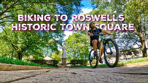
Road Biking To Roswell GA Historic Square | Roswell River Trail
In this video, I road bike the Roswell River Trail to Roswell Historic District where we check out the neat town square with old-growth trees and Victorian, antebellum architecture.
This route is on Alltrails and a nice street ride. Unfortunately, the uphill towards the end is hard, but a great workout!
_____________________________________________________________________________________________
EQUIPMENT WE USE: 🎥
GoPro– https://amzn.to/36LZl1z
GoPro Max Lens Mod - https://amzn.to/3rdgNWQ
Merch:
https://www.redbubble.com/people/buildthedream/shop
GET IN CONTACT:
Email - buildthedream777@gmail.com
Website - https://buildthedreamnow.com
SUPPORT MY WORK - https://account.venmo.com/u/Tony-Hossri
The Roswell Historic District, in Roswell, Georgia in Fulton County, was listed on the National Register of Historic Places in 1974.[1]
Structures in the district date from as early as 1837.[2]
Willis Ball, from Connecticut, was builder and/or designer/architect of four buildings: Primrose Cottage, Roswell Presbyterian Church, Bulloch Hall, Barrington Hall.
The district includes Bulloch Hall and Barrington Hall, both built in 1839, which were separately listed on the National Register in 1971.[2][1] It includes Greek Revival architecture and Late Georgian architecture amongst its 28 contributing buildings and three contributing structures. It also includes a contributing site, the Roswell town square.[1][2]
Roswell Town Square, described as "the Boston Common of this most southern of New England villages", which includes historic monuments[2]
https://en.wikipedia.org/wiki/Roswell_Historic_District_(Roswell,_Georgia)
Who are we?
We believe that life doesn't have to be the same day every day. You can Build The Dream life through exploration, travel, & adventure.
DISCLAIMER: This video and description contains affiliate links, which means that if you click on one of the product links, I’ll receive a small commission. This helps support the channel and allows us to continue to make videos like this. Thank you for the support!
#roadbiking #adventure #Outdoors #Georgia #boardwalk #chattahoochee #bikinglife #trails #active #streetbiking
59
views
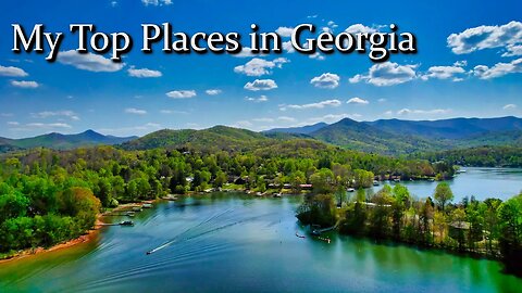
Georgia's 10 MUST SEE Places to Visit
I've traveled to every city in Georgia, USA. And also to just about every notable place from mountains, waterfalls, historic sites, archaeological sites, etc. Out of every place, I narrowed it to my honest 10 best places to visit in the state of Georgia, USA.
_____________________________________________________________________________________________
Merch:
https://www.redbubble.com/people/buildthedream/shop
GET IN CONTACT:
Email - buildthedream777@gmail.com
Website - https://buildthedreamnow.com
SUPPORT MY WORK - https://account.venmo.com/u/Tony-Hossri
Georgia is a state in the Southeastern region of the United States, bordered to the north by Tennessee and North Carolina; to the northeast by South Carolina; to the southeast by the Atlantic Ocean; to the south by Florida; and to the west by Alabama. Georgia is the 24th-largest state in area and 8th most populous of the 50 United States. Its 2020 population was 10,711,908, according to the U.S. Census Bureau.[5] Atlanta, a "beta(+)" global city, is both the state's capital and its largest city. The Atlanta metropolitan area, with a population of more than 6 million people in 2021, is the 8th most populous metropolitan area in the United States and contains about 57% of Georgia's entire population.[6]
Founded in 1732 as the Province of Georgia and first settled in 1733, Georgia became a British royal colony in 1752. It was the last and southernmost of the original Thirteen Colonies to be established. Georgia is defined by a diversity of landscapes, flora, and fauna. The state's northernmost regions include the Blue Ridge Mountains, part of the larger Appalachian Mountain system. The Piedmont plateau extends from the foothills of the Blue Ridge south to the Fall Line, an escarpment to the Coastal Plain defining the state's southern region. Georgia's highest point is Brasstown Bald at 4,784 feet (1,458 m) above sea level; the lowest is the Atlantic Ocean. With the exception of some high-altitude areas in the Blue Ridge, the entirety of the state has a humid subtropical climate. Of the states entirely east of the Mississippi River, Georgia is the largest in land area.[11]
https://en.wikipedia.org/wiki/Georgia_(U.S._state)
Who are we?
We believe that life doesn't have to be the same day every day. You can Build The Dream life through exploration, travel, & adventure.
DISCLAIMER: This video and description contains affiliate links, which means that if you click on one of the product links, I’ll receive a small commission. This helps support the channel and allows us to continue to make videos like this. Thank you for the support!
#georgia #georgiacities #usa #bestplaces #bestplace
Timecodes
0:00 - Intro
0:37 - Driftwood Beach
1:25 - Tallulah Gorge
2:27 - Amicalola Falls
3:07 - Savannah, GA
3:57 - Mount Yonah
4:25 - Lake Chatuge
5:03 - Cloudland Canyon
5:56 - Helen, GA
6:42 - Etowah Indian Mounds
7:42 - Providence Canyon
8:23 - Summary
62
views
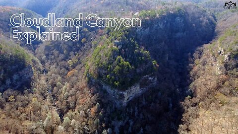
Top 3 Trails of Cloudland Canyon Explained
In this video, I explain the 3 prominent trails of Cloudland Canyon located in Georgia, USA. I also touch on camping. Below are our full videos of each hike!
The Waterfalls Trail
https://www.youtube.com/watch?v=mtTyY9B1Odg
Sitton's Gulch
https://www.youtube.com/watch?v=dm45onTa2QE
West Rim Loop
https://www.youtube.com/watch?v=WIES8eo47s0
Equipment We Use 🎥
Main Camera - https://amzn.to/3fTXmKf
GoPro– https://amzn.to/36LZl1z
Drone - https://amzn.to/3AZMzHq
Camera Shotgun Mic - https://amzn.to/39XVEar
Tony’s Backpack – 5.11 RUSH12 – https://amzn.to/3vZZpCd
Water Filter - https://amzn.to/3Ptp9Sd
_________________________________________________________________________________________
Merch:
https://www.redbubble.com/people/buildthedream/shop
GET IN CONTACT:
Email - buildthedream777@gmail.com
Website - https://buildthedreamnow.com
SUPPORT MY WORK - https://account.venmo.com/u/Tony-Hossri
_____________________________________________________________________________________________
The Park contains several well-marked trails which allow visitors to view the geology of the canyon and its surroundings.[1] A paved, wheelchair-accessible trail about 0.25 miles (0.40 km) long overlooks the rim of the canyon. The park also features four more extensive hiking trails, including one backpacking trail. These trails are generally considered moderate in difficulty.[8]
The Waterfalls Trail begins on a paved section, at the main overlook, and progresses into the canyon along a 40-degree slope. Most of the trail consists of gravel, and a 600-step staircase.[7] Each waterfall emanates from Daniel Creek, and both cascade down sheer faces at 60 feet (18 m) and 90 feet (27 m). The trail is generally considered to be a strenuous hike, which can take up to 90 minutes to complete.[8] Cherokee Falls is 0.3 miles (0.48 km) from the trailhead; Hemlock Falls, at the bottom of the canyon, appears at 0.5 miles (0.80 km).[9] Each cascades into small pools at the base of the canyon, and continue down through a boulder-strewn stream bed. The creek flow feeding the waterfalls varies considerably according to the season. The Sitton's Gulch trail, commencing at the bottom of the Waterfalls Trail, runs parallel to the creek until it ends in a parking area in Trenton.
In contrast, the 4.8-mile (7.7 km) long West Rim Loop Trail is rated as moderately difficult, although it contains a few short, steep rocky sections.[10] A scenic hike[11] beginning at the Daniels Creek Bridge, it offers panoramic views before climbing out of the canyon and onto the plateau. This trail also provides views of Trenton, Georgia, neighboring Sand Mountain, and of Cloudland Canyon. Rhododendron and mountain laurel thickets are interspersed with sour gum and dogwood; large oaks, hickories, hemlocks and maples shade the trail. Cottages and walk-in camping areas are accessible via the West Rim Loop. Passing over varied terrain, most of the hike is moderately difficult, and is considered strenuous along several short sections.
The 2.0-mile (3.2 km) Backcountry Loop Trail provides access to the park's eleven secluded primitive hike-in camping sites.[12] Beginning at the parking area for group camping, the trail passes through hemlock groves, before descending on a moderate grade into a hollow filled with spring and summer flowers. At the far end of the loop, hikers emerge from the hemlock groves onto level trail, among oaks and hickories, before returning to the parking area.
https://en.wikipedia.org/wiki/Cloudland_Canyon_State_Park
Who are we?
We believe that life doesn't have to be the same day every day. You can Build The Dream life through exploration, travel, & adventure.
DISCLAIMER: This video and description contains affiliate links, which means that if you click on one of the product links, I’ll receive a small commission. This helps support the channel and allows us to continue to make videos like this. Thank you for the support!
#Hikes #Scenic #trails #lookoutmountain #hiking #scenictrail #georgia #canyon #gorges #buildthedream #views
Timecodes
0:00 - Intro
0:18 - The Waterfalls Trail
1:32 - Sittons Gulch Trail
2:37 - West Trim Loop Trail
3:23 - Camping
38
views

Comparing Top 2 Portable Mattresses For Travel (Hazli vs. Better Habitat)
In this video I’m going to compare two of some of the most popular memory foam camping mattresses on Amazon; The BETTER HABITAT and the Hazli Matrix Air Cell Memory foam pad.
BETTER HABITAT - https://amzn.to/3PgGtd1
Hazli Matrix Air - https://amzn.to/3v0mTsh
Similarities
To start with a few similarities, both mattresses are waterproof, have a machine-washable cover, are made with CertiPUR-US memory foam, and both are priced very similarly.
Size & Weight
You can get the BETTER HABITAT in two sizes; a single or twin-size. But the Hazli Matrix comes in 4 separate sizes; Kids, single, twin, or twin XL. For the twin-size, which is what I have for both, each one is 75 inches long and 36 inches wide. I prefer the twin size since the added room is large enough for both me and my wife or more room for me when it’s just myself on a trip.
Comfort
So let’s get to what matters most, comfort. And as we all comfort is subjective, but here’s what I found. The BETTER HABITAT is made with memory foam and cotton and is slightly more firm than the Hazli Matrix which is made of 2/3 high-density base support foam with the upper 1/3 layer of memory foam.
Both of them offer plenty of support and each is marketed to be 3 inches thick. But after measuring each one, the BETTER HABITAT is actually slightly thicker than 3 inches while the Hazli is slightly less than 3 inches. Naturally, as a result, BETTER HABITAT is more supportive.
If you prefer a more supportive and firm mattress, the BETTER HABITAT is a better choice. But if you rather have a softer pad, the Hazli is a better option. However, the material of the BETTER HABITAT is much more comfortable than the Hazli as the Hazli feels kind of like a sleeping bag. But on the flip side, the Hazli material also feels cooler than the BETTER HABITAT’s.
Personally, I think the BETTER HABITAT is, overall, more comfortable. But both are great options.
Convenience
Next is convenience and without question, the BETTER HABITAT is much more convenient than the Hazli. The integrated straps make it effortless to roll out and roll up while the Hazlie’s separate straps make it a bit annoying and timely to put it away.
Build Quality
The build quality of both pads is great and roughly tied. Both seem to be made with tough material that’s also waterproof with a machine-washable cover. I highly doubt you’ll have any longevity issues with them.
Our Winner | Portable Mattresses For Travel
While the Hazli truly is a great choice, I prefer the BETTER HABITAT due to its added convenience with the built-in straps, and the additional support, and in my opinion, it’s the more comfortable choice.
_____________________________________________________________________________________________
Merch:
http://www.redbubble.com/people/buildthedream
GET IN CONTACT:
Email - buildthedream777@gmail.com
Website - https://buildthedreamnow.com
SUPPORT MY WORK - https://account.venmo.com/u/Tony-Hossri
Who are we?
We believe that life doesn't have to be the same day every day. You can Build The Dream life through exploration, travel, & adventure.
DISCLAIMER: This video and description contains affiliate links, which means that if you click on one of the product links, I’ll receive a small commission. This helps support the channel and allows us to continue to make videos like this. Thank you for the support!
#campingmattress #portablemattress #comparison
Timecodes
0:00 - Intro
0:12 - Similarities
0:27 - Size Options
0:53 - Comfort
2:22 - Convenience / Rollup
3:12 - Build Quality
3:32 - Portability
3:59 - My Favorite & Why
34
views
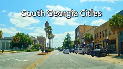
6 Largest South Georgia Cities Explained | USA
Here are the 6 largest cities in south Georgia. I try to briefly summarize each city.
_____________________________________________________________________________________________
Merch:
https://www.redbubble.com/people/buildthedream/shop
GET IN CONTACT:
Email - buildthedream777@gmail.com
Website - https://buildthedreamnow.com
SUPPORT MY WORK - https://account.venmo.com/u/Tony-Hossri
Georgia is a state in the Southeastern region of the United States, bordered to the north by Tennessee and North Carolina; to the northeast by South Carolina; to the southeast by the Atlantic Ocean; to the south by Florida; and to the west by Alabama. Georgia is the 24th-largest state in area and 8th most populous of the 50 United States. Its 2020 population was 10,711,908, according to the U.S. Census Bureau.[5] Atlanta, a "beta(+)" global city, is both the state's capital and its largest city. The Atlanta metropolitan area, with a population of more than 6 million people in 2021, is the 8th most populous metropolitan area in the United States and contains about 57% of Georgia's entire population.[6]
Founded in 1732 as the Province of Georgia and first settled in 1733, Georgia became a British royal colony in 1752. It was the last and southernmost of the original Thirteen Colonies to be established. Georgia is defined by a diversity of landscapes, flora, and fauna. The state's northernmost regions include the Blue Ridge Mountains, part of the larger Appalachian Mountain system. The Piedmont plateau extends from the foothills of the Blue Ridge south to the Fall Line, an escarpment to the Coastal Plain defining the state's southern region. Georgia's highest point is Brasstown Bald at 4,784 feet (1,458 m) above sea level; the lowest is the Atlantic Ocean. With the exception of some high-altitude areas in the Blue Ridge, the entirety of the state has a humid subtropical climate. Of the states entirely east of the Mississippi River, Georgia is the largest in land area.[11]
https://en.wikipedia.org/wiki/Georgia_(U.S._state)
Who are we?
We believe that life doesn't have to be the same day every day. You can Build The Dream life through exploration, travel, & adventure.
DISCLAIMER: This video and description contains affiliate links, which means that if you click on one of the product links, I’ll receive a small commission. This helps support the channel and allows us to continue to make videos like this. Thank you for the support!
#southgeorgia #georgia #georgiacities #usa
65
views
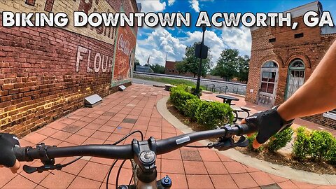
Biking Logan Farm Park & Downtown Acworth, GA
In this video, I street bike Acworth, Georgia downtown than bike the nearby Logan Farm Park that's 2.3 miles. Really cool trail with many parks along the way.
_____________________________________________________________________________________________
EQUIPMENT WE USE: 🎥
GoPro– https://amzn.to/36LZl1z
GoPro Max Lens Mod - https://amzn.to/3rdgNWQ
Merch:
https://www.redbubble.com/people/buildthedream/shop
GET IN CONTACT:
Email - buildthedream777@gmail.com
Website - https://buildthedreamnow.com
SUPPORT MY WORK - https://account.venmo.com/u/Tony-Hossri
Acworth is a city in Cobb County, Georgia, United States. It is part of the Atlanta metropolitan area. As of the 2020 census, this city had a population of 22,440, up from 20,425 in 2010. Acworth is located in the foothills of the North Georgia mountains along the southeastern banks of Lake Acworth and Lake Allatoona on the Etowah River. Unincorporated areas known as Acworth extend into Bartow, Cherokee and Paulding counties.
Acworth's is often referred to as "the Lake City" because of its proximity to Lake Allatoona and Lake Acworth.[2]
https://en.wikipedia.org/wiki/Acworth,_Georgia
Who are we?
We believe that life doesn't have to be the same day every day. You can Build The Dream life through exploration, travel, & adventure.
DISCLAIMER: This video and description contains affiliate links, which means that if you click on one of the product links, I’ll receive a small commission. This helps support the channel and allows us to continue to make videos like this. Thank you for the support!
#mountainbike #MTB #Outdoors #Georgia #mountainbiking #mountainbikinglife #trails #active
11
views
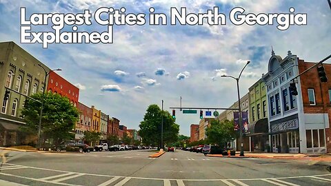
4 Largest North Georgia Cities (Besides Atlanta Metro)
Here are the 4 largest cities in North Georgia besides the Atlanta metro area. (AKA. Just north of the atl metropolitan area and suburbs. I try to briefly summarize each city.
_____________________________________________________________________________________________
Merch:
http://www.redbubble.com/people/build...
GET IN CONTACT:
Email - buildthedream777@gmail.com
Website - https://buildthedreamnow.com
SUPPORT MY WORK - https://account.venmo.com/u/Tony-Hossri
Georgia is a state in the Southeastern region of the United States, bordered to the north by Tennessee and North Carolina; to the northeast by South Carolina; to the southeast by the Atlantic Ocean; to the south by Florida; and to the west by Alabama. Georgia is the 24th-largest state in area and 8th most populous of the 50 United States. Its 2020 population was 10,711,908, according to the U.S. Census Bureau.[5] Atlanta, a "beta(+)" global city, is both the state's capital and its largest city. The Atlanta metropolitan area, with a population of more than 6 million people in 2021, is the 8th most populous metropolitan area in the United States and contains about 57% of Georgia's entire population.[6]
Founded in 1732 as the Province of Georgia and first settled in 1733, Georgia became a British royal colony in 1752. It was the last and southernmost of the original Thirteen Colonies to be established. Georgia is defined by a diversity of landscapes, flora, and fauna. The state's northernmost regions include the Blue Ridge Mountains, part of the larger Appalachian Mountain system. The Piedmont plateau extends from the foothills of the Blue Ridge south to the Fall Line, an escarpment to the Coastal Plain defining the state's southern region. Georgia's highest point is Brasstown Bald at 4,784 feet (1,458 m) above sea level; the lowest is the Atlantic Ocean. With the exception of some high-altitude areas in the Blue Ridge, the entirety of the state has a humid subtropical climate. Of the states entirely east of the Mississippi River, Georgia is the largest in land area.[11]
https://en.wikipedia.org/wiki/Georgia_(U.S._state)
Who are we?
We believe that life doesn't have to be the same day every day. You can Build The Dream life through exploration, travel, & adventure.
DISCLAIMER: This video and description contains affiliate links, which means that if you click on one of the product links, I’ll receive a small commission. This helps support the channel and allows us to continue to make videos like this. Thank you for the support!
#northgeorgia #georgia #georgia #georgiacities #usa
83
views

Blankets Creek Expert Jump Trail | Downhill Mountain Biking "The Holler"
In this video, I mountain bike a downhill expert trail with many jumps. Located in Blankets Creek Mountain Biking Park, I attempt The Holler Trail. However, I'm relatively new to mountain biking. So let's see how this goes lol.
This MTB trail is in Holly Springs, Georgia near Canton located northwest of Atlanta. I highly recommend this area for MTB!
_____________________________________________________________________________________________
EQUIPMENT WE USE: 🎥
GoPro– https://amzn.to/36LZl1z
GoPro Max Lens Mod - https://amzn.to/3rdgNWQ
Merch:
https://www.redbubble.com/people/buildthedream/shop
GET IN CONTACT:
Email - buildthedream777@gmail.com
Website - https://buildthedreamnow.com
SUPPORT MY WORK - https://account.venmo.com/u/Tony-Hossri
Who are we?
We believe that life doesn't have to be the same day every day. You can Build The Dream life through exploration, travel, & adventure.
DISCLAIMER: This video and description contains affiliate links, which means that if you click on one of the product links, I’ll receive a small commission. This helps support the channel and allows us to continue to make videos like this. Thank you for the support!
#mountainbike #MTB #Outdoors #Georgia #mountainbiking #mountainbikinglife #trails #active
31
views
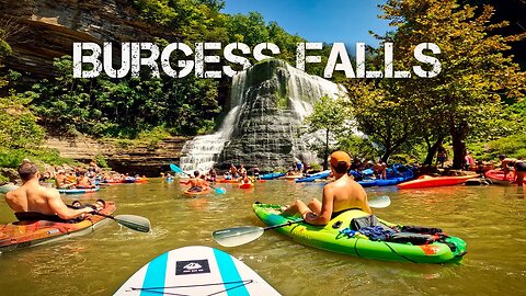
One of Americas Best Paddle-In Waterfalls | Kayaking Burgess Falls
In this video, we kayak and SUP paddleboard to one of the country's best paddle-in waterfalls, Burgess Falls. Located in Sparta, Tennessee, this amazing waterfall is arguably one of the best and most popular in the state.
We took off from the Cookeville Boat Dock, which is roughly 10 miles total out and back. However, if you want the much closer route to the falls, Cane Hollow Rec Area is your best option. Not to forget, the voyage is much more scenic starting from Cane Hollow Rec Area since the various dead trees within the water give it character. You're not missing out on too much starting from Cookeville besides a great workout and a lot of vitamin D.
Equipment We Use 🎥
Main Camera - https://amzn.to/3fTXmKf
GoPro– https://amzn.to/36LZl1z
Drone - https://amzn.to/3AZMzHq
Camera Shotgun Mic - https://amzn.to/39XVEar
Tony’s Backpack – 5.11 RUSH12 – https://amzn.to/3vZZpCd
Water Filter - https://amzn.to/3Ptp9Sd
Tony's Hiking Shoes - https://amzn.to/3F9YEgo
_________________________________________________________________________________________
Merch:
https://www.redbubble.com/people/buildthedream/shop
GET IN CONTACT:
Email - buildthedream777@gmail.com
Website - https://buildthedreamnow.com
SUPPORT MY WORK - https://account.venmo.com/u/Tony-Hossri
_____________________________________________________________________________________________
Burgess Falls State Park is a state park and state natural area in Putnam County and White County, Tennessee, located in the southeastern United States. The park is situated around a steep gorge in which the Falling Water River drops 250 feet (76 m) in elevation in less than a mile, culminating in a 136-foot (41 m) cataract waterfall.
The Burgess Falls State Natural Area, which covers 350 acres (1.4 km2), is managed by the Tennessee Department of Environment and Conservation.
Middle Falls along the Falling Water River
The Falling Water River rises near the base of the Cumberland Plateau in eastern Putnam County and winds its way across the Highland Rim to its mouth along the Center Hill Lake impoundment of the Caney Fork, which is located in an area where the Highland Rim drops off into the Central Basin. The Burgess Falls State Natural Area comprises the section of the river just above its mouth, where the river drops from roughly 900 feet (270 m) atop the Highland Rim to just over 600 feet (180 m) at Center Hill Lake.
Over a long period of time, the Falling Water River's rapids have cut a deep gorge just above its mouth. The river drops to the Central Basin in a series of cascades and waterfalls, each gaining in size and intensity as the river approaches Center Hill Lake. At the Falling Water Cascades, located just downstream from the old Burgess Falls Dam, the river gradually spills over a 10-foot (3.0 m) embankment of rocks. Almost immediately downstream from the Cascades, the river drops another 30 feet (9.1 m) at Little Falls. Beyond Little Falls, where the river briefly bends to the north, is an 80-foot (24 m) cascade known as Middle Falls. Downstream from Middle Falls, where the river bends westward again, is the 136-foot (41 m) Burgess Falls. The distance between Falling Water Cascades and Burgess Falls is less than a mile. Burgess Falls spills into a large limestone gorge enclosed by sheer walls 100–200 feet (30–60 m) high. The Falling Water River enters Center Hill Lake downstream from Burgess Falls.
https://en.wikipedia.org/wiki/Burgess_Falls_State_Park
Who are we?
We believe that life doesn't have to be the same day every day. You can Build The Dream life through exploration, travel, & adventure.
DISCLAIMER: This video and description contains affiliate links, which means that if you click on one of the product links, I’ll receive a small commission. This helps support the channel and allows us to continue to make videos like this. Thank you for the support!
#Paddleinwaterfall #Outdoors #Tennessee #SUP #Scenic #standuppaddleboard #waterfall #Burgessfalls #swimminghole #bestwaterfalls #kayaking #Travel #kayak #buildthedream #waterfalls
76
views
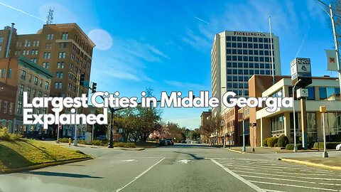
3 Largest Cities in Middle Georgia, USA
Here are the 3 largest cities in middle Georgia. I try to briefly summarize each city.
_____________________________________________________________________________________________
Merch:
https://www.redbubble.com/people/buildthedream/shop
GET IN CONTACT:
Email - buildthedream777@gmail.com
Website - https://buildthedreamnow.com
SUPPORT MY WORK - https://account.venmo.com/u/Tony-Hossri
Georgia is a state in the Southeastern region of the United States, bordered to the north by Tennessee and North Carolina; to the northeast by South Carolina; to the southeast by the Atlantic Ocean; to the south by Florida; and to the west by Alabama. Georgia is the 24th-largest state in area and 8th most populous of the 50 United States. Its 2020 population was 10,711,908, according to the U.S. Census Bureau.[5] Atlanta, a "beta(+)" global city, is both the state's capital and its largest city. The Atlanta metropolitan area, with a population of more than 6 million people in 2021, is the 8th most populous metropolitan area in the United States and contains about 57% of Georgia's entire population.[6]
Founded in 1732 as the Province of Georgia and first settled in 1733, Georgia became a British royal colony in 1752. It was the last and southernmost of the original Thirteen Colonies to be established. Georgia is defined by a diversity of landscapes, flora, and fauna. The state's northernmost regions include the Blue Ridge Mountains, part of the larger Appalachian Mountain system. The Piedmont plateau extends from the foothills of the Blue Ridge south to the Fall Line, an escarpment to the Coastal Plain defining the state's southern region. Georgia's highest point is Brasstown Bald at 4,784 feet (1,458 m) above sea level; the lowest is the Atlantic Ocean. With the exception of some high-altitude areas in the Blue Ridge, the entirety of the state has a humid subtropical climate. Of the states entirely east of the Mississippi River, Georgia is the largest in land area.[11]
https://en.wikipedia.org/wiki/Georgia_(U.S._state)
Who are we?
We believe that life doesn't have to be the same day every day. You can Build The Dream life through exploration, travel, & adventure.
DISCLAIMER: This video and description contains affiliate links, which means that if you click on one of the product links, I’ll receive a small commission. This helps support the channel and allows us to continue to make videos like this. Thank you for the support!
#middlegeorgia #georgia #georgiacities #usa
81
views