

Surface Water and Ocean Topography
SWOT: Earth Science Satellite Will Help Communities Plan for a Better Future
A new Earth science mission, led by NASA and the
French space agency Centre National d'Études
Spatiales (CNES), will help communities plan for a
better future by surveying the planet's salt and
freshwater bodies. The Surface Water and Ocean
Topography (SWOT) mission will measure the height
of water in lakes, rivers, reservoirs, and the oceans.
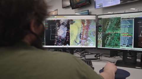
As climate change accelerates the water cycle, more communities around the world will be inundated with water while others won't have enough. SWOT data will be used to improve flood forecasts and monitor drought conditions, providing essential information to water management agencies, civil engineers, universities, the U.S. Department of Defense, disaster preparedness agencies, and others who need to track water in their local areas. In this video, examples of how SWOT data will be used in these communities are shared by a National Weather Service representative in Oregon, an Alaska Department of Transportation engineer, researchers from the University of Oregon and University of North Carolina, a NASA Jet Propulsion Laboratory scientist workingwith the Department of Defense, and a JPL scientist working with the Louisiana Coastal Protection and Restoration Agency.
5
views

Chasing spirites in electrical skies
Paul Smith is a night-sky fanatic and photographer. His obsession is sprites: immense jolts of light that flicker high above thunderstorms. Last October, he guided NASA scientist Dr. Burcu Kosar through the backroads of Oklahoma to catch one herself. Although she'd studied sprites for more than 15 years, she hadn't yet chased one.
12
views