
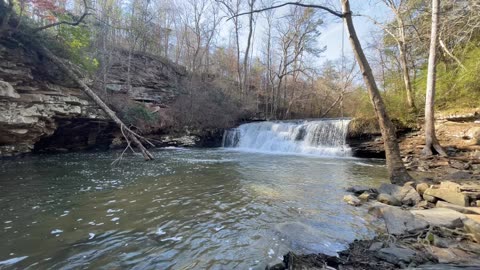
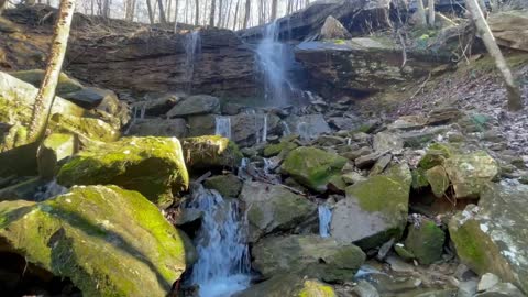
Weaver Falls - Pea Ridge, Alabama
Weaver Falls is a secluded waterfall located 4 miles West of Montevallo, Alabama in a town called Pea Ridge. This waterfall flows off of Jim’s Branch. It drops about 35 feet into a pool below. It’s a little difficult to reach. The road is gravel and rutted out in a few places. This area is used for hunting so I wouldn’t recommend visiting during deer season.
12
views
The Secret Place - Fort Payne, Alabama
The Secret Place offers an amazing and peaceful atmosphere with a special view. From weddings to day retreats, this place is a perfect setting for those wanting an amazing scenery. This is private property and allow people to come with a reservation. You can come for a couple hours or the day. We provide a picnic table, corn hole, fire pit, and more. Please call or message The Secret Place on Facebook to set up a reservation. Located in Fort Payne Alabama.
15
views
Greg’s Two Falls - Little River Canyon Nature Preserve - Fort Payne, Alabama
Gregg’s Two Falls in located in Little River Canyon off a tributary (Wolf Creek) of the Little River.
It’s a short (0.3 mi) hike along Wolf Creek from the road, following a faint trail down to the upper falls.
The descent into the second falls is a short and steep hike but well worth the view from the bottom. The lower falls is small but at the right angle you can see both falls cascading together. The bottom falls has a pool that looks inviting for an afternoon swim.
14
views
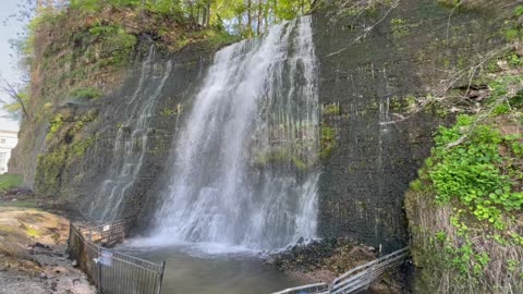
Peavine Falls & Tranquility Lake Dam - Oak Mountain State Park - Pelham, Alabama
Peavine Falls is an approximately 65 foot tall, spring fed waterfall located at the top most ridge in Oak Mountain State Park. There are many trail options for you to choose from to reach the falls, so be sure to plan your route before you arrive. It’s a steep climb down to the falls base, but rewarding to play in the pool of water below.
Tranquility Lake Loop via Foothills Trail
This is a moderate loop trail to Tranquility Lake in Oak Mountain State Park. This trail goes by Oak Mountain Old Lake Dam.
26
views
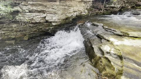
Brooks Branch Falls - Little River Canyon Nature Preserve
Brooks Branch Falls is located inside Little River Canyon Nature Preserve in Fort Payne, Alabama. If you follow the canyon rim parkway, not far past Lynn Overlook you will pass over Brooks Branch.
There is an unofficial overlook where three or four cars can park. There is a way down to the branch and on to the river but it’s pretty difficult. The first step down from the overlook, maybe 10 ft, is the most challenging step because you have to utilize a tree trunk beside a stone wall to climb up and down.
A nice little waterfall which is just below the road marks the head. There is no trail. You just follow Brooks Branch to the river. It isn't far, but getting there involves climbing around boulders and hopping rocks across the branch.
This waterfall is best viewed after heavy rain.
20
views
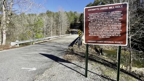
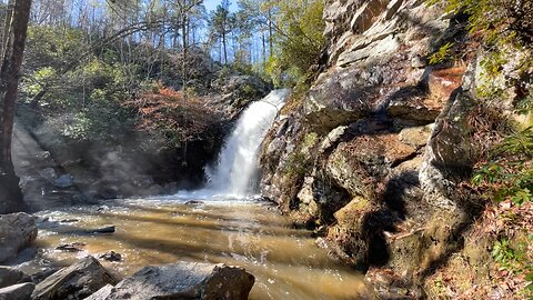
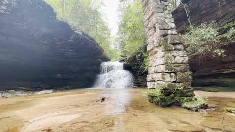
Congo Falls Park - Congo Alabama
Congo Falls is located inside Congo Nature Preserve and borders Little River Canyon National Preserve in Cherokee County Alabama. Congo Nature Preserve was developed to protect area lands along the canyon within Congo, Alabama.
Congo, Alabama is a recently discovered, lost historical community from the late 1800s named Congo. Congo Falls Park is formally known as Johnny’s Creek Mill Hole. In the 1800s this area was owned by the McClung brothers, J.B. and Thomas. The two brothers harnessed power from water that flowed over the falls to operate a sawmill and grist mill. The McClung's two mills and blacksmith shop played an important role for families in the Black Oak and Tucker's Chapel during the depression. Because of the scarcity of money, the people in the community returned to the barter system; Goods and services were traded for goods and services. Some of the rock foundation of the mills are still visible from the top of the falls.
Congo Nature Preserve now has trails open to the public. Congo Falls Park was officially opened to the public May 2021. Congo Nature Preserve is in the process of developing a Nature Walk and Bird Sanctuarywithin its boarder. What was once ATV hunting trails will now be converted to build a safe place for all ages to explore.
Access for swimming, hiking, sightseeing, picnicking, or parking at Congo Falls Park requires a single use permit from May 1st to October 1st. Season permits are only available from September 13th to April 30. Boater/Kayaker permits are also available at no charge but only from September 13th to April 30th and subject to approval.
Permits are not required during the off season of October 1st to May 1st.
55
views
Desoto State Park - Fort Payne, Alabama
DeSoto State Park is a public recreation area located on Lookout Mountain 8 miles northeast of Fort Payne, Alabama. The state park covers 3,502 acres of forest, rivers, waterfalls, and mountain terrain. It borders the Little River, which flows into the nearby Little River Canyon National Preserve.
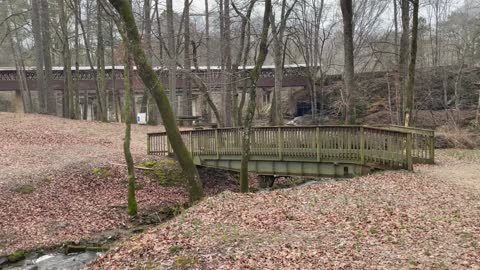
The Azalea Cascade Boardwalk Trail: This trail was planned and built through a community effort. It was constructed by the Alabama State Parks Maintenance Crew. Azalea Cascade Boardwalk Trail's Gazebo Boardwalk is a beautiful place to see Mountain Laurel bloom. The Boardwalk is a 360-yard trail that can be enjoyed and traveled by people of all abilities. No matter what the season, the boardwalk gives the hiker a unique perspective of the surrounding habitat. A 20-foot octagon deck at the end of the trail places you over the pool created by the Azalea Cascade. A mid-April walk encircles you with the fragrant aroma of wild azaleas. Flowering Season usually ranges from March-November.
Indian Falls: This interesting waterfall falls about 20 feet into a small ravine, located just across the road from the Azalea Cascade Trailhead. Indian Falls is about 0.1 miles from the trailhead and is easily reached over a small footpath. A wooden footbridge crosses over the top of this beautiful sight.
Laurel Creek: This is a small creek that flows downstream and forms Lost Falls, Laurel Fall, Azalea Cascade, and Indian Falls. Small Laurel Creek then connects with Little River.
Lost Falls: This waterfall is the hardest to find in DeSoto State Park, mostly because when no water is flowing, it is truly lost! The best time to see this small 5 foot waterfall is in the Spring or Winter seasons. Lost Falls is located about 1.5 miles from DeSoto’s Country Store and terrain can be moderate to mildly strenuous.
Lodge Falls: This easy to find waterfall is located just behind DeSoto’s Lodge. Lodge Falls drops about 25 feet and is very rainfall dependant. The best view point of this waterfall is reached by hiking down into a small ravine and then getting on the yellow trail for a short distance and coming back out next to the Lodge.
80
views
Fagan Springs - Wildflower Trail - Monte Sano - Huntsville, Alabama - DJI FPV Drone
The Wildflower Trail is located in Huntsville, Alabama. The trail begins at the Land Trust's Cleermont Trailhead and follows Fagan Creek up the mountain to the Fagan Springs Trail. Although this trail is narrow, technical, and steep in places, any hike up this trail is rewarded with views of Fagan Springs and its accompanying waterfalls almost any time of the year. You will find three waterfalls on this trail.
14
views
Ditto Falls - Lacey Springs, Alabama
Ditto Falls is located on private property south of Huntsville in Lacey Springs. It is easy to find if you know where to look. It is absolutely a hidden gem. Let’s keep it that way.
5
views
Seven Falls - Falkville, Alabama
Seven falls is located off of Seven Falls Creek in Falkville, Alabama. This secluded waterfall is on property owned by a hunting club and should be accessed at-own-risk, especially considering the land is used for hunting. Access requires significant bushwhacking, as the creek has thick brush along the banks and no trail exists. It’s best to hit this waterfall after heavy rain.
7
views
Buck’s Pocket State Park
Located in three counties (DeKalb, Jackson and Marshall) and secluded in a natural pocket, Bucks Pocket State Park is one of the most peaceful & tranquil places in Alabama. The park is a pocket of beauty atop Sand Mountain's plateau. Known for the sweeping views of its rugged, seemingly untouched landscape provided from the heights of Point Rock.
Hikers and horseback riders are particularly attracted to the park's 18 miles of trails. They range from one-quarter mile to six miles in length, traverse dense forests and high bluffs, and offer glimpses of the valley below. One of the most popular trails is Point Rock Trail, which leads from the park office on the floor of the canyon up to the overlook. This trail follows a creek up the canyon and has an elevation change of 400 feet.
Along the trail you will follow Little Sauty Creek as it tumbles down the slopes of Sand Mountain. You’ll encounter a somewhat short, but steep, portion about a quarter-mile from the Point Rock boardwalk.
Just a few yards from the steepest section, you can walk to the bottom of Little Sauty Falls and view it from various angles.
87
views
Hurricane Creek Park - Vinemont, Alabama
Hurricane Creek Park is located just off Highway 31 in South Vinemont, Alabama. This unique park is nestled in a 500-foot-deep canyon in the foothills of the Appalachian Mountains called Hurricane Creek Gorge.
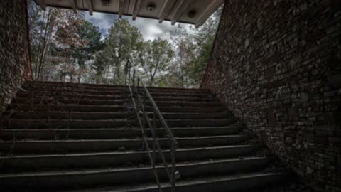
Visitors can spend the day trekking or bird watching along the four miles of designated hiking trails that wind through the lush woods, unique rock formations and cliff sides of the gorge. Notable locations in the park that were formed by the weathering of natural rock include Twilight Tunnel, the Stairway to Heaven, and Dead Man’s Squeeze.
Along the trails you will see several waterfalls. One rolls over a large bluff and you can walk behind it. Another waterfall has a wooden bridge that leads you across the base of the falls. Most of the waterfalls are seasonal and only flow after a heavy rain. I found 8 waterfalls. There is a swimming hole just above the dam to cool off after your hike.
Those longing for fresh air and breathtaking natural scenery will find Hurricane Creek Park to be an ideal destination. The park is open daily from sunrise to sunset, and admission is free.
47
views
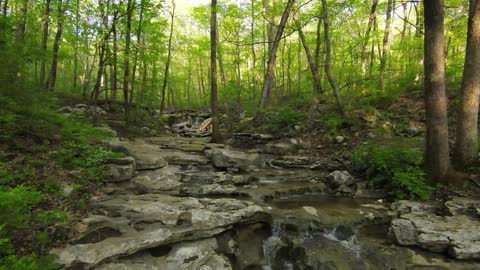
Bankhead National Forest Waterfall Tour - Sipsey Wilderness - Land of a Thousand Waterfalls
The William B. Bankhead National Forest is one of Alabama's four National Forests, covering 181,230 acres. It is home to Alabama’s only National Wild and Scenic River, the Sipsey Fork.
Bankhead National Forest is sometimes referred to as the "Land of a Thousand Waterfalls.” These waterfalls are perhaps some of the most exquisite waterfalls in the world.
As you hike one of the 90 miles of recreational trails past tall moss-covered bluffs, beneath deep rock shelters, and alongside the many rivers and streams that vein through the land carving out an incredible canyon, it literally looks like there is a waterfall tumbling down the sandstone walls around every bend. Some are named, most are not.
Kinlock Falls has a 15-foot drop and a span of more than 20 feet. It truly is one of Alabama's hidden gems. Other than its scenic beauty, one of Kinlock Falls best features is its pool at the bottom. Over the years, this spot has become one of the area's most popular swimming holes.
By following the trail further downstream, you'll experience a different view of Kinlock Falls and encounter another waterfall called Kinlock Chute.
Parker Falls is located within the Sipsey Wilderness area of the BNF. The trail begins on Kinlock Road near Kinlock Falls.
The Quillen Creek Trail is located near Mount Hope, Alabama. This is a difficult 4.9 mile hike that requires some navigation skills. There are multiple creek crossings, boulder scrambling, and crawling under/over fallen trees. At times, there is no visible trail to follow so it’s very easy to get turned around.
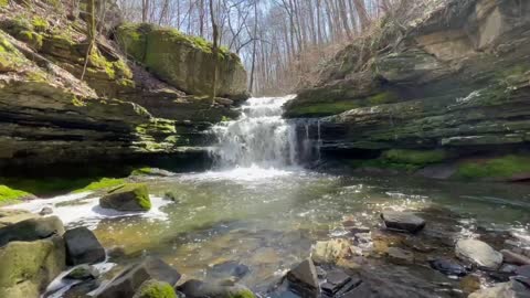
White Creek Falls is a secluded waterfall located in BNF. It consists of 2 beautiful waterfalls. You will follow mostly marked trails but it is partially off-trail. The Valentine Pool looks deep enough for a quick swim before heading back up the canyon.
Eagle Creek Falls is an off-the-beaten-path destination in the Sipsey Wilderness area of BNF. Eagle Creek Falls is a gradual cascade of about 20 feet with a small pool at the bottom. If you hike downstream from Eagle Creek Falls you will find several other waterfalls.
Deer Skull Falls is actually two waterfalls that come together beside each other. Deer Skull Falls is unique because of it's glowing orange color "iron ore" that bleeds out through the rock. The second waterfall beside Deer Skull towers up about 80 feet and drops by steps as it cascades down the canyon.
Fall Creek Falls is a 25-foot-tall ribbon waterfall that tumbles down the sandstone wall of the canyon, crashing to a halt on the boulders below.
Mize Mill Falls is located in the Sipsey Wilderness section of the Bankhead National Forest in southeastern Lawrence County, Alabama. The waterfall itself is about 20 feet and tumbles into a rocky basin that makes for a secluded spot. Moss-covered rock faces line both sides of the creek, while sunlight streams through the treetops. If fairies existed, this’d be where they’d hang out.
Turkey Creek Falls is tucked away in a little dark green moss-covered alcove of the gorge that has been carved by the creek over the centuries.
One of the most recognizable, and arguably the most photographed, waterfalls in the Bankhead National Forest is Caney Creek Falls. This trail will lead you to a stunning 30 foot-tall waterfall spilling down over the top of a rock ledge into a mesmerizing turquoise pool. The rock ledge is deep and tall enough for you to walk behind the curtain of water. This waterfall is also one of Alabama's best swimming holes.
Holmes Chapel Falls offers a scenic 60 foot drop into a bowl carved into the sandstone. The hike is relatively flat and enjoyable along the creek to the main fall, with moss and boulders around every turn.
Coal Mine Branch Falls is located in the Brushy Creek area. The waterfall requires a bit of a hike, but the protected bowl at the base of the falls coupled with the bright green moss makes this a cool scene.
Sougahoagdee Falls is a 30 foot fall nestled in a hollow off of Brushy Creek. Bluffs rise from the creek to form a natural bowl with the falls spilling over from above at one end. Ferns and lush greenery make it feel a little like some kind of hidden paradise.
Key Mill Branch Falls is located in the Northeastern part of BNF in the Brushy Creek watershed. During times of normal winter rainfall, there are close to a dozen waterfalls. Twisted falls is one of my favorites in this area. The water falls and then makes a 90 degree turn before falling again.
Shangri-la Falls is located off of Collier Creek. It is surrounded by crystal clear blue water and luscious Hemlock trees providing this unique tropical setting. This picturesque waterfall feels like paradise.
If you hike downstream about 1/2 mile you will reach Collier Creek Falls. The waterfall was once the site of a large gristmill. Two huge stone columns approximately 20 feet high held a waterwheel and are still presently intact. The columns date back to the early 1900’s.
197
views
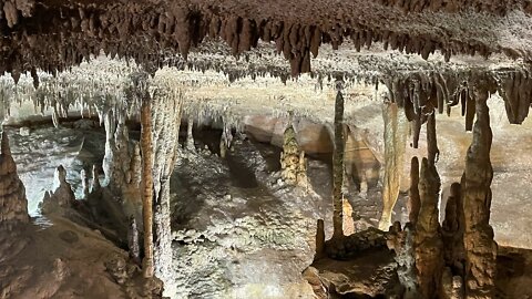
Rickwood Caverns - Cullman, Alabama
Rickwood Caverns State Park is a publicly owned recreation area and natural history preserve located 7 miles north of Warrior, Alabama. The 380-acre state park offers tours of the caverns with illuminated limestone formations estimated to be 260 million years old.
The park features an Olympic-sized swimming pool, picnic area with shelters, hiking trails, playground, campground, panning for gemstones and gift shop. Described as "mysterious and beautiful", the caverns feature guided tours of the so-called "miracle mile" of active "living" formations, old fossils which are clearly visible in the soft limestone walls, spring-fed pools, and other curiosities.
The caverns were brought to public attention by Eddie Rickles and Sonny Arwood who combined their own names to create the name "Rickwood." Rickles had come across the caves in the early 1950s as the leader of a Boy Scout troop exploring the area.
If you’re looking to cool off from the sweltering summer temperatures or warm up during those cold winter months, the underground wonder maintains a constant 58-62 degree temperature year round as you travel 175 feet beneath the earth.
25
views
Desoto State Park - Fort Payne, Alabama
DeSoto State Park is a public recreation area located on Lookout Mountain 8 miles northeast of Fort Payne, Alabama. The state park covers 3,502 acres of forest, rivers, waterfalls, and mountain terrain. It borders the Little River, which flows into the nearby Little River Canyon National Preserve.
The Azalea Cascade Boardwalk Trail: This trail was planned and built through a community effort. It was constructed by the Alabama State Parks Maintenance Crew. Azalea Cascade Boardwalk Trail's Gazebo Boardwalk is a beautiful place to see Mountain Laurel bloom. The Boardwalk is a 360-yard trail that can be enjoyed and traveled by people of all abilities. No matter what the season, the boardwalk gives the hiker a unique perspective of the surrounding habitat. A 20-foot octagon deck at the end of the trail places you over the pool created by the Azalea Cascade. A mid-April walk encircles you with the fragrant aroma of wild azaleas. Flowering Season usually ranges from March-November.
Indian Falls: This interesting waterfall falls about 20 feet into a small ravine, located just across the road from the Azalea Cascade Trailhead. Indian Falls is about 0.1 miles from the trailhead and is easily reached over a small footpath. A wooden footbridge crosses over the top of this beautiful sight.
Laurel Creek: This is a small creek that flows downstream and forms Lost Falls, Laurel Fall, Azalea Cascade, and Indian Falls. Small Laurel Creek then connects with Little River.
Lost Falls: This waterfall is the hardest to find in DeSoto State Park, mostly because when no water is flowing, it is truly lost! The best time to see this small 5 foot waterfall is in the Spring or Winter seasons. Lost Falls is located about 1.5 miles from DeSoto’s Country Store and terrain can be moderate to mildly strenuous.
Lodge Falls: This easy to find waterfall is located just behind DeSoto’s Lodge. Lodge Falls drops about 25 feet and is very rainfall dependant. The best view point of this waterfall is reached by hiking down into a small ravine and then getting on the yellow trail for a short distance and coming back out next to the Lodge.
82
views
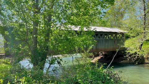
Clarkston Covered Bridge - Cullman, Alabama
Clarkson Covered Bridge is one of Cullman's most well known attractions and historically rich sites. The bridge was originally built in 1904, and was once used regularly by farmers and travelers to cross Crooked Creek. The weatherworn bridge is now closed to traffic, the centerpiece of a park built in period fashion to showcase the bridge and its historical significance. The bridge was torn in two in 1921 by a huge storm. One piece was left intact, the other swept down stream and soon salvaged. One year later, the project to repair the bridge with the salvaged material was completed.
On June 25, 1974, Clarkson Covered Bridge was named to the National Register of Historic Places. Shortly thereafter, in 1975, the Cullman County Commission restored the site with the help of concerned citizens as part of the American Bicentennial Project, embellishing the grounds with hiking trails, a picnic area, and two period structures built to accent the historical nature of the bridge: a Dogtrot log cabin and a working grist mill.
43
views
Memorial Mound - Abandoned Mausoleum in Bessemer, Alabama Haunted
Memorial Mound is an abandoned underground mausoleum located in Bessemer, Alabama.
Clyde Booth, a former gravedigger and construction engineer, envisioned creating an underground burial mausoleum. As a young boy digging graves with his Uncle, he witnessed first-hand unkempt graves and overgrown grounds. Booth thought he could come up with a better burial technique. In 1969, he began studying burial mounds and the catacombs of Rome as a hobby, astounded that both still remained today. At the age of sixty-seven, Booth set out to build his dream in Alabama, a place he hoped people would visit for centuries to come.
In 1990, Booth purchased a 16-acre lot in Bessemer, Alabama. His idea of an earth-covered mound would be like an underground mausoleum which opened in 1992
The facility’s foundation sits eight feet below ground level with a large interior room serving as a chapel. It has separate wings on each side with metal racks for caskets and cremated remains.
In 1996, four years after opening with less than a dozen burials, Memorial Mound abruptly closed its doors. Since Booth didn’t operate as a full-service funeral home, he did not have to abide by the Alabama Board of Funeral Service guidelines.
Clyde Booth believed his financial failure was a conspiracy by the local funeral homes who began recommending burial elsewhere. The grounds remained secured and relatives were still able to visit for the next few years. However, by 2000 the doors were locked and Memorial Mound was closed for good. Sadly, Clyde Booth passed away in 2009 at the age of 89. Memorial Mound became abandoned after his death and quickly fell into a state of neglect. Vandals tore apart anything they could use for scrap metal even dismantling chairs from the chapel. This left the facility in complete disarray.
Most of the burials came from local funeral homes and many of the caskets were not sealed or were direct burials. This would prove to be detrimental over time, causing the bodies to break down and fluids to leak from the caskets. Local authorities knew of Memorial Mound for years and the neglected shape it was in, but failed to do anything about it until late 2014 after photos surfaced online of the remaining corpses. The remains of one infant and seven bodies were removed by authorities and taken to the coroner’s office until families could determine final arrangements. Once the bodies were removed the mausoleum was sealed shut. Authorities were unsuccessful when attempting to reach Booth’s family. Clyde Booth had good intentions, but many believe he did not thoroughly research the concept.
218
views
1
comment
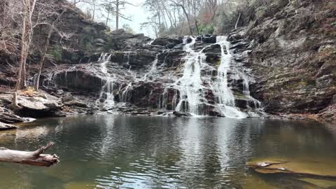
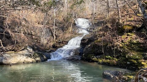
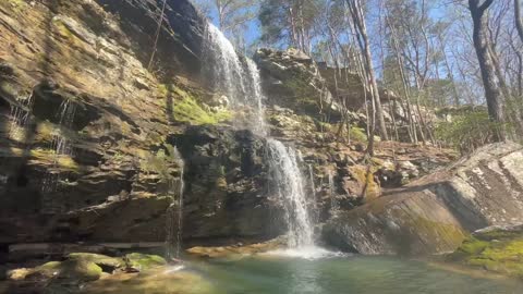
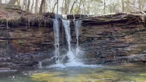
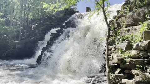
Salt Creek Falls - Talladega National Forest
One of the largest cascading waterfalls in Alabama is Salt Creek Falls. It features a nice cascade with a deep swimming hole below the falls. Salt Creek Falls is located in the Talladega National Forest. The hike to the falls is fairly easy, but the climb down the mountain to reach the bottom of the falls is very difficult and dangerous.
32
views
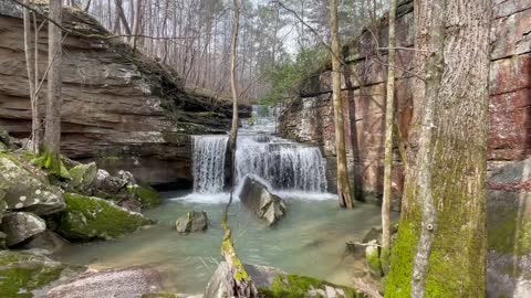
Lower White Creek Falls, Upper White Creek Falls & Valentine's Pool - Bankhead National Forest
White Creek Falls is a secluded waterfall located in the Bankhead National Forest. It consists of 2 beautiful waterfalls. You will follow mostly marked trails but it is partially off-trail.
The trail is 6.5 miles round trip and is rated as difficult. The hike starts on system trail 201, which you take until you see signs for 209. Trail 209 will come to a fork in the path (Sipsey Fork). At this point, hike off the trail downstream (follow the footpath) until you reach the first drainage. This is White Creek. Hike up the drainage along White Creek until you reach Lower White Creek Falls.
After exploring Lower White Creek Falls, you can reach Upper White Creek Falls and Valentine Pool by following a narrow footpath up the rock ledge. BE CAREFUL! There’s a steep drop off here and it’s very slippery. A short hike upstream and you will reach Upper White Creek Falls and Valentine Pool. The Valentine Pool looks deep enough for a quick swim before heading back up the canyon.
31
views
Wilson Dam, TVA Rockpile Recreation Area Waterfall - Florence, Alabama
The Wilson Dam waterfall is on a high rock wall adjacent to Wilson Dam on the south bank. Small feeder creeks run through the natural area and create this waterfall on an adjacent cliff wall.
This accessible trail provides breathtaking views of historic Wilson Dam, the Tennessee River and a series of waterfalls. There are always a variety of birds playing in the waters below the Dam, and the limestone bluffs are magnificent. The mist from the waterfall cools you down after a long hike.
21
views
Chewacle Falls - Auburn, Alabama
Chewacla State Park is home to both natural and man made waterfalls. The most popular falls is man made and is located on the backside of the lake. Water cascades over the unique masonry found here year-round and serves as a photo-friendly destination.
16
views
Cold Water Falls - Spring Park - Tuscumbia, Alabama
This man-made waterfall, situated in Spring Park, was constructed with more than 2,000 tons of local sandstone. It stretches 80 feet wide and 42 feet tall. 4.3 million gallons of water pass over the falls each day.
14
views
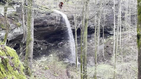
Falling Rock Falls - Montevallo, Alabama
Falling Rock Falls is located within the Cahaba River National Wildlife Refuge near Montevallo, Alabama. This scenic trail has an easy rating and is 1.8 miles out and back. It's perfect for all skill levels. While hiking the Falling Rock Falls Trail, you'll encounter lots of scenery. However, it's the 90-foot waterfall at the end of the trail that makes the hike well worth it.
When you get to the trailhead, park near the gate and walk down the road. Take the first road on the left about 0.5 miles in and follow the road to the next right turn. After walking another 1/4 mile, take the road to the left with the dirt mounded in front of it down the hill to the falls. Once you get there, you'll be able to hear the falls. USE CAUTION! You will approach from the top of the falls and the edge of the cliff can sneak up on you.
From there, you can follow the trail on the right to the bottom of the falls and explore the cavern behind the falls.
If you walk downstream from Falling Rock Falls you will see a second waterfall on the left. You don’t want to miss this.
18
views
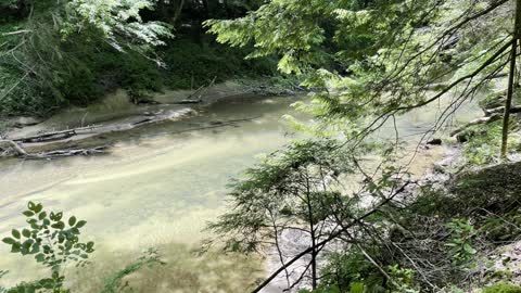
Turkey Creek Nature Preserve - Pinson, Alabama
Turkey Creek, a tributary of the Locust Fork River, is located 20 minutes north of Birmingham near the community of Pinson. Turkey Creek is home to three endangered species of fish: the Vermilion Darter (Etheostoma chermocki), Watercress Darter (Etheostoma nuchale), and Rush Darter (Etheostoma phytophilum). The Rush and Vermilion Darters are only found in Turkey Creek and nowhere else in the world.
Rated as one of Alabama’s top swimming holes, Turkey Creek offers one of the state’s best places to beat the heat. When you drop the shoes after leaving the trail, take a dip in the creek via a moss covered sandstone slip ‘n slide. Let the crystal clear water push you down as it plunges over a series of drops that have a carved out body-shaped channel, which guides you safely through the cascade and into the pool below. Even in the heat of a scorching Alabama summer, the waters in Turkey Creek are cool and refreshing.
48
views