
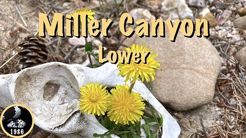
Hiking Lower Miller Canyon, Mogollon Rim
Hiking the lower portion of Miller Canyon: Starting from FR 9724V, I dropped down a steep & brush-choked gully, into Miller Canyon, just below Crackerbox Canyon. From the canyon bottom, I hiked Miller Canyon to its end at East Clear Creek. I then climbed out along the Arizona Trail to FR 123A. New flower species for me today included creeping barberry and rough whitlowgrass.
In the Coconino National Forest, Miller Canyon flows downhill, north from the Mogollon Rim at Hi View Point to East Clear Creek, just upstream from C.C. Craigan Reservoir. Miller Canyon is bounded by Miller Ridge, Blazed Ridge, McCarty Ridge and Battleground Ridge.
Blog: http://prestonm.com/lower-miller-canyon-mogollon-rim/
Twitter: https://twitter.com/PrestonMcMurry
____________________
"Whiskey and Wine", On Tour
https://freemusicarchive.org/music/On_Tour/Folkrock/on_tour_-_folkrock_-_07_whiskey_and_wine/
https://creativecommons.org/licenses/by-nc-sa/3.0/
28
views

Hiking General Crook Trail: V51-V57
Hiking the 8th segment of the General Crook Trail from FR 137 (V51), in the Coconino National Forest, to FR 115 (V51) in the Sitgreaves National Forest, via Myrtle Lake, East Leonard Canyon and Lake Number Four, with a stop by the G.D. Bantz grave.
P markers represent miles west of Camp Verde. V markers represent miles east of Camp Verde.
In 1871, General George Crook surveyed a supply road west from Fort Apache, Arizona, across the Mogollon Rim to Camp Verde, then on to Fort Whipple in Prescott. The General Crook Road was built in 1872. The Army used the road until 1896, and civilians until 1928, when Rim Road replaced it.
Blog: http://prestonm.com/general-crook-trail-v51-v57/
Twitter: https://twitter.com/PrestonMcMurry
____________________
"Gone Again", Beat Mekanik
https://freemusicarchive.org/music/beat-mekanik/single/gone-again/
https://creativecommons.org/licenses/by/4.0/
190
views
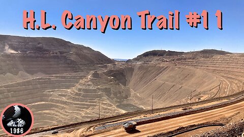
Hiking HL Canyon Trail #11
Hiking HL Canyon Trail #11, off the former "Devil's Highway", 10 miles north of the Morenci Mine, in Greenlee County.
Blog: http://prestonm.com/hl-canyon-trail-11/
Twitter: https://twitter.com/PrestonMcMurry
____________________
"I'm Gonna' Work", HoliznaCC0
https://freemusicarchive.org/music/holiznacc0/everything-hurts/im-gonna-work/
https://creativecommons.org/publicdomain/zero/1.0/
40
views
1
comment

Hiking General Crook Trail: V6-V16
Hiking the 3rd segment of the General Crook Trail from Clear Creek Campground, across West Clear Creek, over Wingfield Mesa, along Black Mountain Canyon, past Thirteenmile Rock Butte, to Sawlog Tank #2 / FR 9243D. (I skipped the eight "sidewalk" miles through the town of Camp Verde.) Tons of flowers!
In 1871, General George Crook surveyed a supply road west from Fort Apache, Arizona, across the Mogollon Rim to Camp Verde, then on to Fort Whipple in Prescott. The General Crook Road was built in 1872. The Army used the road until 1896, and civilians until 1928, when Rim Road replaced it.
P markers represent miles west of Camp Verde. V markers represent miles east of Camp Verde.
Blog: http://prestonm.com/general-crook-trail-v6-v16/
Twitter: https://twitter.com/PrestonMcMurry
____________________
"Won't see it comin' (Feat Aequality & N'sorte d'autruche)", Alpha Hydrae
https://freemusicarchive.org/music/Alpha_Hydrae/uu_/Alpha_Hydrae_-_Alpha_Hydrae_-_uu__-_10_Wont_see_it_comin_Feat_Aequality__Nsorte_dautruche/
https://creativecommons.org/publicdomain/zero/1.0/
57
views

Kingsnake's Dashcam #118
A lot of my non-hiking spare time the last few months has gone into working on the Sunnyslope Murder Tour ( https://rumble.com/v4fmhsc-sunnyslope-murder-tour.html ). Sunnyslope isn't a large neighborhood, but this yearwe had a homicide in February, March and April. Plus a 10-year old cold case was solved in April. And I am tracking them all.
In the meantime,enjoy some Phoenix Traffic Stress Disorder (PTSD)!
1) Meth addict shenanigans.
2) Cripple shenanigans.
3) Bum shenanigans.
4) Algebra.
5) Mobster.
____________________
Blog: http://prestonm.com
Twitter: https://twitter.com/PrestonMcMurry
32
views
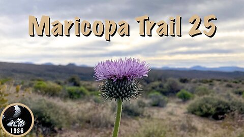
Maricopa Trail: Bartlett Dam Rd. to FR 1058
Hiking the first part of the 25th and final Maricopa Trail ( https://vimeo.com/manage/showcases/8309613/info ) segment from the Cave Creek Ranger Station on Bartlett Dam Road to Forest Road 1058, in the Tonto National Forest.
273
views
1
comment

Hiking Beer 2024
Celebrating National Beer Day* in the United States with my 9th annual video of beers consumed before, during & after my hikes.
Beers include Chimay Grande Reserve, St. Bernardus Abt 12, La Chouffe Blonde, Grand Canyon Prickly Pear Wheat Ale and Pabst Blue Ribbon (PBR)consumed in locations as diverse as the Petrified Forest, Haunted Canyon, Black Canyon Trail, in Telluride, and along the C&O Canal.
Zicke, zacke, zicke, zacke, hoi, hoi, hoi!
Blog: http://prestonm.com/hiking-beer-9/
Twitter: https://twitter.com/PrestonMcMurry
____________________
"Keep Yer Hands Off My PBR", Scuzz Twittly
* Prohibition was repealed by the Cullen–Harrison Act on April 7, 1933, so April 6 is referred to as New Beer's Eve.
35
views
3
comments
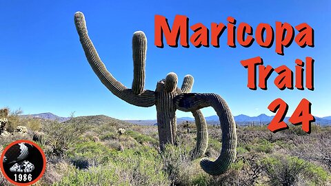
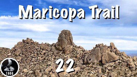
Maricopa Trail: Granite Mountain TH to Bartlett Dam Rd.
Hiking the 24th of 25 Maricopa Trail ( https://vimeo.com/manage/showcases/8309613/info ) segments from Granite Mountain Trailhead to Bartlett Dam Rd. in the Tonto National Forest, via Bootlegger Trail, Granite Mountain Trail, Branding Iron Trail, The Divide Trail and Dove Valley Trail.
____________________
"Adagio assai", Dee Yan-Key
https://freemusicarchive.org/music/Dee_Yan-Key/war-and-peace/adagio-assai/
https://creativecommons.org/licenses/by-nc/4.0/
224
views

Kingsnake's Dashcam #117
Phoenix Traffic Stress Disorder (PTSD) lowlights
1) Holy crap!
2) Sunnyslope. *shrug*
3) One of these days ...
4) Red light algebra.
5) Another brick in the wall.
____________________
Blog: http://prestonm.com/kingsnakes-dashcam-117/
Twitter: https://twitter.com/PrestonMcMurry
52
views

Skyline Regional Park Hike
Hiking Quartz Mine Trail, Tortuga Trail and Javelina Summit Trail in Buckeye’s Skyline Regional Park. Lots of F-35 Lightning II’s overhead from Luke Air Force Base. Javelina Summit has great views!
Blog: http://prestonm.com/skyline-regional-park-4/
Twitter: https://twitter.com/PrestonMcMurry
____________________
“Be Cool”, Mr Smith
https://freemusicarchive.org/music/mr-smith/streamliner/be-cool/
https://creativecommons.org/licenses/by/4.0/
50
views
2
comments
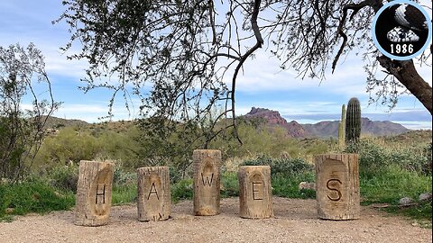
Hawes Trail System Hike
Hiking Hawes Trail #52, Magic Mountain Trail, Saddle Trail #51, Saguaro Trail #50, and Granite Trail #54 in the Hawes Trail System in the Tonto National Forest. Red Mountain visible mos of the day, as was Schlechts Butte.
Blog: http://prestonm.com/hawes-trail-system/
Twitter: https://twitter.com/PrestonMcMurry
____________________
"No, really. Everything is fine.", Aaron Ximm
https://freemusicarchive.org/music/Aaron_Ximm/Handpans_and_the_Hang/Aaron_Ximm_-_02_-_No_Really_Everything_is_Fine/
https://creativecommons.org/licenses/by-nc-sa/3.0/us/
223
views

Sunnyslope Murder Tour
This episode: Erin Place Apartments, Circle K stabbing murder; "The Mayor of Sunnyslope" hit & run; Retta Renee Cruse commits maternal filicide; and a viral video.
Sunnyslope Murder Tour is a series where I visit the sites of homicides and murders* that have occurred in the violent Phoenix Sunnyslope neighborhood since I moved here in 2008.
*Every murder is a homicide, but not every homicide is a murder.
____________________
Blog: http://prestonm.com/sunnyslope-murder-tour/
Twitter: https://twitter.com/PrestonMcMurry
180
views
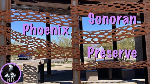
Hiking the Phoenix Sonoran Preserve
From Desert Hills Trailhead, just off Carefree Highway, I hiked a short loop of Ocotillo Trail and Sidewinder Trail in the Phoenix Sonoran Preserve.
____________________
"Bird on a Wire", Snake Oil Salesmen
https://freemusicarchive.org/music/Snake_Oil_Salesmen/Snake_Oil_Salesmen/Snake_Oil_Salesmen_-_Snake_Oil_Salesmen_-_04_Bird_on_a_Wire/
https://creativecommons.org/licenses/by-nc/4.0/
61
views
2
comments
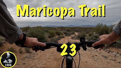
Maricopa Trail: Tom's Thumb TH to Granite Mountain TH
Mountain biking the 23rd of 25 Maricopa Trail ( https://vimeo.com/manage/showcases/8309613/info ) segments from Tom's Thumb Trailhead to Granite Mountain Trailhead in Scottsdale's McDowell Sonoran Presrve, via Marcus Landslide Trail, Gooseneck Trail, Black Hill Trail and Turpentine Trail.
____________________
Blog: http://prestonm.com/maricopa-trail-toms-thumb-th-to-granite-mountain-th/
Twitter: https://twitter.com/PrestonMcMurry
420
views
2
comments

Kingsnake's Dashcam #116
Phoenix Traffic Stress Disorder (PTSD) lowlights
1) You might be a redneck ...
2) Suicide Lane.
3) You can't park there!
4) Dragging the Line.
5) HazMat.
____________________
Blog: http://prestonm.com
Twitter: https://twitter.com/PrestonMcMurry
54
views
Maricopa Trail: Gateway Trailhead to Tom's Thumb Trailhead
Hiking the 22nd of 25 Maricopa Trail ( https://vimeo.com/manage/showcases/8309613/info ) segments from Gateway Trailhead to Tom's Thumb Trailhead in Scottsdale's McDowell Sonoran Presrve, via Saguaro Trail, Gateway Loop Trail, Windgate Pass Trail and Tom's Thumb Trail.
Blog: http://prestonm.com/maricopa-trail-gateway-trailhead-to-toms-thumb-trailhead/
Twitter: https://twitter.com/PrestonMcMurry
____________________
"Crimson Moon", Stray Dogg
https://freemusicarchive.org/music/Stray_Dogg/Almost/Stray_Dogg_-_Almost_-_02_Crimson_Moon_1435/
https://creativecommons.org/licenses/by-nc-sa/3.0/
307
views
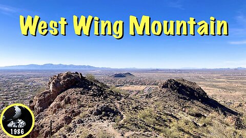
Hiking West Wing Mountain, Peoria, Arizona
From the Sunrise Mountain Trailhead, I hiked Golden Cliffs Trail, Canyon Overlook Trail and Western Overlook Trail on West Wing Mountain, in the Peoria Paloma Preserve. Good punch for a short hike. Great views!
Blog: http://prestonm.com/west-wing-mountain/
Twitter: https://twitter.com/PrestonMcMurry
____________________
"Big Disco Ball (Instrumental Version)", Josh Woodward
https://freemusicarchive.org/music/Josh_Woodward/Crawford_Street/JoshWoodward-CS-NoVox-04-BigDiscoBall/
https://creativecommons.org/licenses/by/4.0/
418
views

Maricopa Trail: Taliesin West to Gateway Trailhead
Hiking the Maricopa Trail from Taliesin West, along the Hayden-Rhodes Aqueduct; past McDowell Mountain Golf Club; through McDowell Mountain Ranch; onto Quartz Trail, Paradise Trail and Gateway Loop Trail, to Gateway Trailhead.
Blog: http://prestonm.com/maricopa-trail-taliesin-west-to-gateway-trailhead/
Twitter: https://twitter.com/PrestonMcMurry
____________________
"His and Her's", On Tour
https://freemusicarchive.org/music/On_Tour/Folkrock/on_tour_-_folkrock_-_10_his_and_hers/
https://creativecommons.org/licenses/by-nc-sa/3.0/
315
views

Kingsnake's Dashcam #115
My wife -- who also has a dashcam -- is away, visiting family in the Netherlands this fortnight. Hopefully she brings back some decent footage. In the meantime, enjoy!
1) Porn plate?
2) Billy's first motorbike.
3) Personal mistake.
4) You can't stop there!
5) Two accidents in two miles.
____________________
Blog: http://prestonm.com
Twitter: https://twitter.com/PrestonMcMurry
47
views

Maricopa Trail: Detroit Coney Grill to Taliesin West
Maricopa Trail bike ride on the Scottsdale Greenbelt from Detroit Coney Grill, past McCormick Ranch Golf Club and Marguerite Lake, under Hayden Road (and nine other tunnels), past Mountain View Park, then east along Cactus Road to Taliesin West on Frank Lloyd Wright Boulevard.
Blog: http://prestonm.com/maricopa-trail-detroit-coney-grill-to-taliesin-west/
Twitter: https://twitter.com/PrestonMcMurry
____________________
"Cena Slobode", Nafta
https://freemusicarchive.org/music/Nafta/Samo_senke_prolaze/NAFTA-13_Cena_slobode/
https://creativecommons.org/licenses/by-nc-sa/3.0/
181
views

Exploring Picketpost Mountain
I hiked down Arnett Canyon Trail #218, followed a steep use trail out of Arnett Creek, onto a mesa / plateau on the east slope of Picketpost Mountain. Explored the mesa a bit, then bushwhacked down a side canyon, before following Telegraph Canyon back to the Finger Rock.
Blog: http://prestonm.com/picketpost-mesa-explore/
Twitter: https://twitter.com/PrestonMcMurry
____________________
"Canyon Breeze", Montana Skies
https://freemusicarchive.org/music/Montana_Skies/Free_Downloads/Montana_Skies_-_Free_Downloads_-_11_Canyon_Breeze/
https://creativecommons.org/licenses/by-nc-sa/3.0/us/
73
views
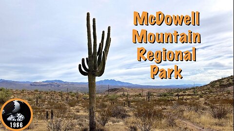
Hiking McDowell Mountain Regional Park
From the Four Peaks Staging Area, I hiked Shallmo Wash Trail, Pemberton Trail and Escondido Trail around the Lousley Hills in McDowell Mountain Regional Park, north of Fountain Hills.
Blog: http://prestonm.com/shallmo-wash-pemberton-escondido/
Twitter: https://twitter.com/PrestonMcMurry
____________________
"Un peu pour rien", Ève C.
https://freemusicarchive.org/music/Eve_C/10_tounes_pour_rien/Un_peu_pour_rien/
https://creativecommons.org/licenses/by-nc-sa/4.0/
166
views

Maricopa Trail: Biking Granite Reef Dam to Detroit Coney Grill
Biking from the Bush Highway, across the Salt River to Granite Reef Dam. From there, I biked the 19th segment of the Maricopa Trail, riding along the Arizona Canal past Red Mountain; played "Frogger" across the Bush Highway; past the scenic Salt River Landfill; crossed the much less busy Mesa Drive, Alma School Road and Pima Road; and finally past Scottsdale Silverado Golf Club to the Detroit Coney Grill on the corner of Hayden Road and Indian Bend Road.
Blog: http://prestonm.com/maricopa-trail-granite-reef-dam-to-detroit-coney-grill/
Twitter: https://twitter.com/PrestonMcMurry
____________________
"Turtle Head", Galapagos
https://genius.com/artists/Galapagos
446
views

Kingsnake's Dashcam #114 : Maryland
Third trip to Hagerstown, Maryland, this year. As is our habit, the fall trip is for Halloween. Even before trick-or-treat, there were plenty of scares to be had …
Phoenix Traffic Stress Disorder (PTSD) lowlights
1) Bad Maryland Drivers.
2) Fun in Frederick!
3) Meat spray.
4) The Weavers.
5) Ocean Front Property.
____________________
Blog: http://prestonm.com
Twitter: https://twitter.com/PrestonMcMurry
25
views
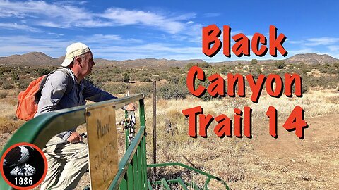
Black Canyon Trail: Orme Rd. to Old Cherry Rd.
Hiking my 14th -- and currently final* -- segment of Arizona's Black Canyon Trail (BCT), northbound from Orme Rd., across Osborne Spring Wash, Ash Creek and Hackberry Wash to the John 3:16-17 spring box on Old Cherry Rd., just south of Highway 169.
*The Black Canyon Trail (BCT) is a National Recreation Trail. Originally 64 miles from Carefree Highway to Big Bug Trailhead on AZ-69, it has grown northwards, and is now 93 miles long, ending at AZ-169 (a different road), near Johnson Wash. I've heard it may one day even extend to Williams, in the pines of northern Arizona.
Blog: http://prestonm.com/co-canal-north-branch-to-cumberland/
Twitter: https://twitter.com/PrestonMcMurry
____________________
"Darkling Skies", Jelsonic
https://freemusicarchive.org/music/Jelsonic/Various_Moods_II/jelsonic-darkling-skies/
https://creativecommons.org/licenses/by/4.0/
220
views