
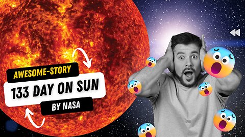
133 Day On Sun
The 133-day timelapse of the Sun by NASA is a video that chronicles solar activity from August 12 to December 22, 2022, as captured by NASA's Solar Dynamics Observatory (SDO). The video shows the Sun's outermost atmospheric layer, the corona, in extreme ultraviolet light.
The video starts with a relatively calm Sun, but as time goes on, more and more active regions appear. These active regions are areas of the Sun's surface where the magnetic field is strongest. They are also the places where solar flares and coronal mass ejections (CMEs) are most likely to occur.
The video shows a number of solar flares and CMEs, including a large flare on September 1, 2022, that was one of the strongest flares of the year. The flare caused a radio blackout in parts of North America and Europe.
The video also shows a number of other solar phenomena, such as prominences, filaments, and coronal holes. Prominences are large loops of plasma that rise up from the Sun's surface. Filaments are long, thin strands of plasma that hang down from the Sun's surface. Coronal holes are areas of the Sun's corona where the magnetic field is weak and the plasma is less dense.
The 133-day timelapse of the Sun is a stunning visual representation of the Sun's activity. It provides a glimpse into the dynamic nature of our star and the processes that drive its behavior. The video is a valuable resource for scientists studying the Sun and its influence on Earth's climate and environment.
You can watch the full video on the NASA Goddard YouTube channel.
Here are some additional details about the video:
The video was created using images taken by SDO's Atmospheric Imaging Assembly (AIA) instrument.
The images were taken at a wavelength of 17.1 nanometers, which is an extreme ultraviolet wavelength that shows the Sun's outermost atmospheric layer: the corona.
The images were compiled every 108 seconds, which means that the video condenses 133 days, or about four months, of solar observations into 59 minutes.
The video shows the Sun rotating from east to west.
The video has been sped up by a factor of 20,000.
I hope this helps!
Sources
svs.gsfc.nasa.gov/14263#:~:text=)%20%5B74.6%20KB%5D-,This%20133%2Dday%20time%20lapse%20of%20the%20Sun%20at%2017.1,plasma%20and%20numerous%20solar%20eruptions.&text=Watch%20this%20video%20on%20the,it%20influences%20the%20solar%20system.
31
views
1
comment

Story reaveal form NASA about chasing sprites in electric skies
🌠 Night 🌩 Thunderstorm 🌨 Clouds ⚡️ Lightning 📷 Camera 🔭 Telescope 🔎 Observation 🛰 Satellite 👩🔬 Scientist 👨🚀 Astronaut 🤩 Wonder 😍 Fascination 🌌 Mystery 🔬 Discovery ✨ Magic
Here is a more detailed version:
Night: The perfect time to chase sprites, as they are only visible in the dark.
Thunderstorm: The source of the sprites, as they are triggered by strong lightning strikes.
Clouds: The sprites form high above the clouds, in the ionosphere.
Lightning: The first sign that a sprite may be about to appear.
Camera: The essential tool for capturing sprites, as they are very faint.
Telescope: Can be used to magnify the sprites and make them easier to see.
Observation: The key to finding and capturing sprites, as they are unpredictable.
Satellite: Can be used to track thunderstorms and help scientists find the best places to chase sprites.
Scientist: The people who study sprites and are working to unlock their secrets.
Astronaut: The people who have seen sprites from space, providing scientists with valuable insights.
Wonder: The feeling that everyone experiences when they see a sprite for the first time.
Fascination: The reason why people are drawn to chase sprites, despite the challenges.
Mystery: The thing that makes sprites so special, as we still don't fully understand them.
Discovery: The hope that one day we will fully understand sprites and their place in the universe.
17
views
Tracking World Water Protecting Communities
NASA's Earth observing satellites are tracking the world's water resources to help protect communities from water scarcity, flooding, and other water-related hazards.
The satellites collect data on a variety of water features, including surface water, groundwater, snow and ice, and water vapor in the atmosphere. This data is used to monitor changes in water availability and quality, identify areas at risk of water-related hazards, and develop strategies to manage water resources sustainably.
For example, NASA's Gravity Recovery and Climate Experiment (GRACE) satellites have been used to track changes in global water storage. The GRACE data has shown that the Earth's water resources are declining, and that this decline is being driven by climate change.
NASA's Landsat satellites have been used to map changes in surface water. The Landsat data has been used to track the expansion of irrigated agriculture, which is a major driver of water scarcity.
NASA's Aqua and Terra satellites have been used to monitor changes in groundwater. The Aqua and Terra data has been used to identify areas where groundwater is being depleted, and to assess the impact of groundwater depletion on ecosystems.
NASA's Sentinel-2 satellites are being used to monitor changes in snow and ice. The Sentinel-2 data is being used to track the retreat of glaciers and ice sheets, which is a major contributor to sea level rise.
NASA's Aura satellite is being used to monitor changes in water vapor in the atmosphere. The Aura data is being used to track the global water cycle, and to assess the impact of climate change on the water cycle.
The data collected by NASA's Earth observing satellites is helping scientists to better understand the world's water resources, and to develop strategies to manage these resources sustainably. This data is also being used to help protect communities from water-related hazards, such as floods and droughts.
In addition to tracking water resources, NASA is also working to develop new technologies to help communities manage their water more effectively. For example, NASA is developing a new satellite that will be able to measure the amount of water in clouds. This data could be used to improve weather forecasts and to help communities prepare for droughts and floods.
NASA is also working to develop new water purification technologies. For example, NASA is developing a new method to remove salt from seawater. This technology could be used to provide clean water to communities that are located in arid areas.
NASA is committed to using its Earth observing satellites and other technologies to help protect communities from water-related hazards and to ensure that everyone has access to clean water.
31
views
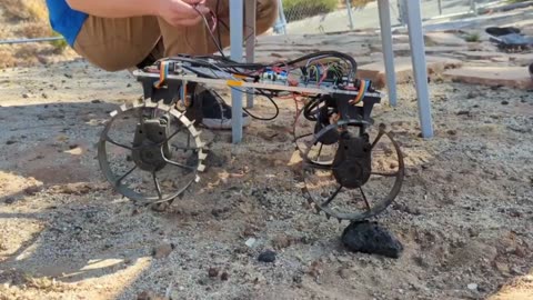
How Robots Help Human Being in Space and Universe
Performing dangerous or difficult tasks: Robots can be used to perform tasks that are too dangerous or difficult for humans, such as repairing the outside of the International Space Station (ISS) or exploring hazardous environments like asteroids or comets.
Gathering data: Robots can be used to gather data in places that are difficult or impossible for humans to reach, such as the surface of Mars or the interior of an active volcano. This data can be used to learn more about the universe and to plan future missions.
Assisting astronauts: Robots can be used to assist astronauts with their daily tasks, such as transporting supplies, conducting experiments, and performing repairs. This frees up astronauts to focus on more important tasks, such as scientific research.
Exploring new worlds: Robots are being developed to explore new worlds, such as Mars. These robots will be able to roam the surface of other planets, collect data, and search for signs of life.
Building structures: Robots are being used to build structures in space, such as the ISS. This is a challenging task that is made easier by robots' ability to work in zero gravity and in harsh environments.
As robotic technology continues to improve, robots will play an even greater role in space exploration. They will help us to explore new worlds, learn more about the universe, and make space travel safer and more efficient.
Here are some specific examples of how robots are helping humans in space:
The Canadarm2 is a robotic arm that is used on the ISS to help with maintenance and repairs. It has also been used to grapple and berth spacecraft, and to deploy satellites.
The Curiosity rover is a robotic explorer that is currently exploring Mars. It has used its cameras, lasers, and other sensors to study the Martian surface and atmosphere.
The Perseverance rover is a robotic explorer that is currently exploring Mars. It is equipped with a drill that can collect samples of Martian rock and soil.
The Ingenuity helicopter is a robotic helicopter that is the first to fly in another planet's atmosphere. It is currently flying on Mars, where it is helping to map the terrain and search for potential landing sites for future missions.
These are just a few examples of how robots are helping humans in space. As robotic technology continues to improve, robots will play an even greater role in space exploration.
29
views