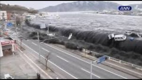
CAUGHT IN THE MIDDLE OF TSUNAMI
A tsunami is a series of waves in a water body caused by the displacement of a large volume of water, generally in an ocean or a large lake. Earthquakes, volcanic eruptions and other underwater explosions above or below water all have the potential to generate a tsunami.
8
views
mountain beach valley
Calayo is a real hidden gem and is a beautiful secluded beach. ... Depending on which resort you are based out, they will even cook it for you. ... some time out on the beach with some sensational mountains in the background. ... Approaching Lorelei Island and a fantastic secluded beach on the southern side of the island.
4
views
super hi wat
The information superhighway or infobahn was a popular term used through the 1990s to refer to digital communication systems and the Internet telecommunications network. It is associated with United States Senator and later Vice-President Al Gore
7
views
1
comment
tunnel hi way
This page presents the same tunnels as in list of tunnels by length in separate lists according to ... 2007, Shijiazhuang–Taiyuan High-Speed Railway ... km of length is one of the longest hydraulic tunnel in the world realised with TBM method.
This page presents a list of the longest road tunnels of the world. This page lists all road tunnels longer than 5 km (3 mi). Contents. 1 World's longest road ...
7
views
1
comment

SIARGAO ISLAND PHILIPPINES
Siargao is a tear-drop shaped island in the Philippine Sea situated 196 kilometers southeast of Tacloban. It has a land area of approximately 437 square kilometres. The east coast is relatively straight with one deep inlet, Port Pilar.
32
views

hot babe
subtle introduction to warmer weather is slowly taking form. Days are getting sunnier, and swimsuit season is nearly upon us. It may feel like we're not going anywhere for a while, but that doesn't mean there aren't brighter days ahead—and who says you can't wear a swimsuit around the house? A classic one-piece or bikini never goes out of style, but summer 2021 is bringing forth a fresh batch of fun swim trends to try. From comfort-first styles to sexy high-cut suits and beyond, these are the top five trends making a splash this season. Shop them now to sport at home in your backyard or later in that dreamy destination on your wish list.
24
views
1
comment
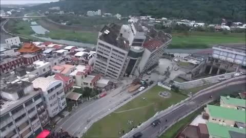
EARTHQUAKE CAUGHT ON CAMERA
An earthquake (also known as a quake, tremor or temblor) is the shaking of the surface of the Earth resulting from a sudden release of energy in the Earth's lithosphere that creates seismic waves. Earthquakes can range in size from those that are so weak that they cannot be felt to those violent enough to propel objects and people into the air, and wreak destruction across entire cities. The seismicity, or seismic activity, of an area is the frequency, type, and size of earthquakes experienced over a period of time. The word tremor is also used for non-earthquake seismic rumbling.
At the Earth's surface, earthquakes manifest themselves by shaking and displacing or disrupting the ground. When the epicenter of a large earthquake is located offshore, the seabed may be displaced sufficiently to cause a tsunami. Earthquakes can also trigger landslides and occasionally, volcanic activity.
In its most general sense, the word earthquake is used to describe any seismic event—whether natural or caused by humans—that generates seismic waves. Earthquakes are caused mostly by rupture of geological faults but also by other events such as volcanic activity, landslides, mine blasts, and nuclear tests. An earthquake's point of initial rupture is called its hypocenter or focus. The epicenter is the point at ground level directly above the hypocenter.
The location below the earth's surface where the earthquake starts is called the hypocenter, and the location directly above it on the surface of the earth is called the epicenter. Sometimes an earthquake has foreshocks. These are smaller earthquakes that happen in the same place as the larger earthquake that follows.
An aftershock is a smaller earthquake that follows a larger earthquake, in the same area of the main shock, caused as the displaced crust adjusts to the effects of the main shock. Large earthquakes can have hundreds to thousands of instrumentally detectable aftershocks, which steadily decrease in magnitude and frequency according to known laws. In some earthquakes the main rupture happens in two or more steps, resulting in multiple main shocks. These are known as doublet earthquakes, and in general can be distinguished from aftershocks in having similar magnitudes and nearly identical seismic wave forms.
Magnitude is the physical size of the earthquake (see cross-section below), the length (L) x the width (W) x the slip (D). An earthquake has a single magnitude. The shaking that it causes has many values thay vary from place to place based on distance, type of surface material, and other factors.
42
views
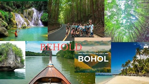
BEHOLD BOHOL"S Destinations
Maribojoc, officially the Municipality of Maribojoc, is a 4th class municipality in the province of Bohol, Philippines. According to the 2015 census, it has a population of 20,688 people. The municipality has a land area of 6,908 hectares.
Tubigon, officially the Municipality of Tubigon, is a 1st class municipality in the province of Bohol, Philippines. According to the 2015 census, it has a population of 45,893 people.
La Purisima Concepcion de la Virgen Maria Parish Church, commonly known as Baclayon Church, is a Roman Catholic Church in the municipality of Baclayon, Bohol, Philippines within the jurisdiction of the Roman Catholic Diocese of Tagbilaran
The Loboc River is a river in the Bohol province of the Philippines. It is one of the major tourist destinations of Bohol. The source of the Loboc River is located in the town of Carmen, almost in the center of Bohol.
21
views

Top 10 beautiful places in the world
Plitviče Lakes National Park is a 295-sq.-km forest reserve in central Croatia. It's known for a chain of 16 terraced lakes, joined by waterfalls, that extend into a limestone canyon. Walkways and hiking trails wind around and across the water, and an electric boat links the 12 upper and 4 lower lakes. The latter are the site of Veliki Slap, a 78m-high waterfall.
Machu Picchu is an Incan citadel set high in the Andes Mountains in Peru, above the Urubamba River valley. Built in the 15th century and later abandoned, it’s renowned for its sophisticated dry-stone walls that fuse huge blocks without the use of mortar, intriguing buildings that play on astronomical alignments and panoramic views. Its exact former use remains a mystery.
Grand Canyon National Park, in Arizona, is home to much of the immense Grand Canyon, with its layered bands of red rock revealing millions of years of geological history.
"Free to visit at any time, the spectacular Fairy Pools are located near the village of Carbost in Glenbrittle on the Isle of Skye. Many tributaries of the River Brittle run down from the Cuillin into the glen including a river with waterfalls known as the Fairy Pools, a popular place for walkers. The Fairy Pools are beautiful rock pools of crystal clear spring water fed by a series of waterfalls.
The Château de Marqueyssac is a 17th-century château and gardens located at Vézac, in the Dordogne Department of France. The château was built at the end of the 17th century by Bertrand Vernet de Marqueyssac, Counselor to Louis XIV, on cliffs overlooking the Dordogne Valley.
Moraine Lake is a glacially fed lake in Banff National Park, 14 kilometres outside the Village of Lake Louise, Alberta, Canada. It is situated in the Valley of the Ten Peaks, at an elevation of approximately 1,884 metres.
Whitehaven Beach is a 7;km stretch along Island, Australia. The island is accessible by boat, seaplane & helicopter from Airlie Beach, as well as Hamilton Island. It lies across from Stockyard Beach, better known as Chalkie's Beach, on Haslewood Island.
Salar de Uyuni, amid the Andes in southwest Bolivia, is the world’s largest salt flat. It’s the legacy of a prehistoric lake that went dry, leaving behind a desertlike, nearly 11,000-sq.-km. landscape of bright-white salt, rock formations and cacti-studded islands. Its otherworldly expanse can be observed from central Incahuasi Island. Though wildlife is rare in this unique ecosystem, it harbors many pink flamingos.
Preikestolen or Prekestolen is a tourist attraction in the municipality of Strand in Rogaland county, Norway. Preikestolen is a steep cliff which rises 604 metres above Lysefjorden. Atop the cliff, there is an almost flat top of approximately 25 by 25 metres.
Experience Private Island Paradise At Our Luxury Resort In The Heart Of French Polynesia. Book Your Stay Today At Four Seasons Resort Bora Bora! Private Snorkel Safari. Sunset Cruises. Breakfast By Boat. Children's Welcome Gift. Private Scuba Diving. Pool Cabanas.
follow me at
https://www.facebook.com/profile.php?id=100065605456010
https://twitter.com/Michael96760750
60
views
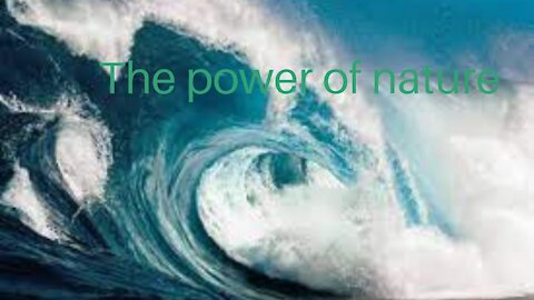
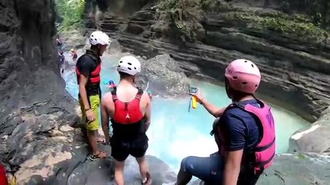
Sea in the city art
Waves are most commonly caused by wind. Wind-driven waves, or surface waves, are created by the friction between wind and surface water. ... These waves roll upon the shore like a massive sea level rise and can reach far distances inland. The gravitational pull of the sun and moon on the earth also causes waves.
3
views

Beach tour
A beach is a landform alongside a body of water which consists of loose particles. The particles composing a beach are typically made from rock, such as sand, gravel, shingle, pebbles, etc., or biological sources, such as mollusc shells or coralline algae. Sediments settle in different densities and structures, depending on the local wave action and weather, creating different textures, colors and gradients or layers of material.
Though some beaches form on freshwater locations, most beaches are in coastal areas where wave or current action deposits and reworks sediments. Erosion and changing of beach geologies happens through natural processes, like wave action and extreme weather events. Where wind conditions are correct, beaches can be backed by coastal dunes which offer protection and regeneration for the beach. However, these natural forces have become more extreme due to climate change, permanently altering beaches at very rapid rates. Some estimates describe as much as 50 percent of the earth's sandy beaches disappearing by 2100 due to climate-change driven sea level rise.[2]
Sandy beaches occupy about one third of global coastlines.[2] These beaches are popular for recreation, playing important economic and cultural roles—often driving local tourism industries. To support these uses, some beaches have man-made infrastructure, such as lifeguard posts, changing rooms, showers, shacks and bars. They may also have hospitality venues (such as resorts, camps, hotels, and restaurants) nearby or housing, both for permanent and seasonal residents.
Human forces have significantly changed beaches globally: direct impacts include bad construction practices on dunes and coastlines, while indirect human impacts include water pollution, plastic pollution and coastal erosion from sea level rise and climate change. Some coastal management practices are designed to preserve or restore natural beach processes, while some beaches are actively restored through practices like beach nourishment.
Marine debris in a beach in Hawaii.
Wild beaches, also known as undeveloped or undiscovered beaches, are not developed for tourism or recreation. Preserved beaches are important biomes with important roles in aquatic or marine biodiversity, such as for breeding grounds for sea turtles or nesting areas for seabirds or penguins. Preserved beaches and their associated dune are important for protection from extreme weather for inland ecosystems and human infrastructure.[2]
28
views

The sea of beauty
The sea is the interconnected system of all the Earth's oceanic waters, including the Atlantic, Pacific, Indian, Southern and Arctic Oceans. ... Seas are generally larger than lakes and contain salt water, but the Sea of Galilee is a freshwater lake.
2
views

BY THE BAY
The ocean is the body of salt water which covers approximately 71% of the surface of the Earth. It is also "any of the large bodies of water into which the great ocean is divided". These five oceans are, in descending order by area, the Pacific, Atlantic, Indian, Southern, and Arctic Oceans. Wikipedia
2
views

Top 10 Amazing Phenomena
So let's take a look at eight of the most amazing natural phenomena.
Northern Lights, Iceland. ...
Sort sol, Denmark. ...
Lightning storm, Venezuela. ...
Moonbow, Zimbabwe. ...
Sailing stone/moving rock, USA. ...
Blood rain, India. ...
Pororoca, Brazil. ...
Luminous water, Thailand.
13
views

Cutest funny pets
Cute Pets And Funny Animals Compilation #16 - Pets Garden
Love Animal - If you also love animals like me please subscribe my channel.
My channel shares animal, travel, cooking, news, adventure clips
John Lester official
3
views
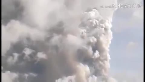
Taal Volcano erruption
The Philippine Institute of Volcanology and Seismology (PHIVOLCS) raised Alert Level 4 on the Taal Volcano on Sunday night, hours after the phreatic eruption that occurred in the crater. At 7:30 p.m. bulletin, PHIVOLCS explained that Alert Level 4 means a dangerous explosion is imminent. ad "Until 5:30 pm, eruptive activity intensified at the Taal Volcano Main Crater as continuous eruption generated a height of 10-15 kilometers tephra with volcanic power raining wet wetlands to the north to in Quezon City, "the agency said. PHIVOLCS added that volcanoes have been continuously recorded since 11 a.m., with 2.5 and 3.9-magnitude quake rocks in Tagaytay City and Alitagtag, Batangas, respectively. The agency encouraged "total evacuation" of Taal Volcano Island and other high-risk areas. taal volcano news, taal volcano eruption, taal volcano update, taal volcano tour, taal volcano crater, taal volcano 2019, taal volcano history, taal volcano race 2019, taal volcano sumabog, taal volcano active, taal volcano alert, taal volcano alert level, taal volcano abs cbn, taal volcano adventure, taal volcano alert level 1 2019, taal volcano before and after, taal volcano boat ride, taal volcano blog, taal volcano balita, taal volcano before eruption, taal volcano talisay batangas, taal volcano caldera, taal volcano close up, taal volcano crater tour, taal volcano crater swimming, taal volcano current status, climbing taal volcano, taal volcano drawing, taal volcano documentary, taal volcano drone shot, taal volcano diorama, taal volcano diagram, taal volcano day trip from manila, taal volcano eruption documentary, taal volcano eruption 1977, taal volcano explode, taal volcano earthquake, taal volcano eruption 2014, taal volcano eruption 1965 video, taal volcano facts, taal volcano first eruption, taal volcano fireworks, view of taal volcano from tagaytay, how taal volcano formed, platinum fireworks taal volcano, taal volcano gmail, taal volcano national geographic, going to taal volcano, taal volcano historical eruptions, taal volcano horseback riding, taal volcano horse ride, taal volcano hike tour, taal volcano hazards, taal volcano hike difficulty, taal volcano height, taal volcano in batangas, taal volcano island, taal volcano inside, taal volcano in tagaytay, taal volcano island within a lake, taal volcano in tagaytay city, taal volcano information, taal volcano island tour, taal volcano island in a lake, i witness taal volcano, jessica soho taal volcano, taal volcano kmjs, taal volcano kuya kim, taal volcano katy perry, kwento ng taal volcano, taal volcano last eruption, taal volcano lava, taal volcano lake, taal volcano last eruption video, taal volcano live, taal volcano location, taal volcano last eruption 1977, taal volcano last eruption exact date, taal volcano montage, taal volcano mystery, taal volcano mouth, taal volcano misconception, taal volcano map, taal volcano manila, matanglawin taal volcano, mt taal volcano eruption, taal volcano news 2019, taal volcano news today, taal volcano november 2019, taal volcano now, taal volcano next eruption, pagsabog ng taal volcano, alamat ng taal volcano, taal volcano overlooking tagaytay, history of taal volcano, history of taal volcano in tagalog, crater of taal volcano, old taal volcano, mouth of taal volcano, legend of taal volcano, taal volcano pagbabago, taal volcano painting, taal volcano platinum fireworks, taal volcano picture, taal volcano philippines, taal volcano pumutok, taal volcano possible eruption, taal volcano protected landscape, taal volcano pronunciation, taal volcano real, taal volcano race 2018, taal volcano restaurant, roar taal volcano, red alert taal volcano, taal volcano status, taal volcano swimming, taal volcano secret trail, taal volcano today, taal volcano tour 2019, taal volcano trip, taal volcano tagaytay tour, taal volcano trekking tour, taal volcano tagaytay view, taal volcano update today, taal volcano update 2019, taal volcano underwater, taal volcano view, taal volcano video, taal volcano view from tagaytay, taal volcano view deck, taal volcano wiki, how taal volcano was formed, where is taal volcano, when taal volcano erupted, taal volcano youtube, taal volcano year of eruption, taal volcano 1965, taal volcano 1911, taal volcano 1754 eruption, taal volcano 1911 eruption, taal volcano 1977 eruption, taal volcano 1754, taal volcano 1965 eruption #taalvolcano #pagsabogngtaal #update breaking news,latest news,ph news,philippine news,taal volcano eruption 2020 abs cbn,taal volcano eruption 2020 lightning,taal volcano eruption 2020 live,taal volcano eruption 2020 news,taal volcano eruption 2020 update,taal volcano eruption abs cbn,taal volcano eruption in philippines,taal volcano eruption lightning,taal volcano eruption live,taal volcano eruption time lapse,taal volcano latest news,taal volcano latest update,taal volcano live,taal volcano news,taal volcano news 2019,taal volcano news live,taal volcano news today,taal volcano news update..
417
views

Mayon Volcano Eruption
As of Wednesday the 17th of January 2018, Mayon Volcano eruption is currently ongoing & at least 34,038 people have been displaced from the Albay Province, located in the Bicol Region in southeastern Luzon of the Philippines.
A state of calamity has been declared in the province of Albay due to the possible violent eruption of Mount Mayon, which as been manifesting intense volcanic activity in the recent week or so.
There were at least 49 tremors overnight associated with the volcanic activity.
Visual monitoring have recorded various intensities of pyroclastic flows as well as emission of ash clouds & gases, including the dislodging of boulders & the fountaining & flowing of lava.
One of the streams of lava was flowing for an estimated two kilometers down the slope of the volcano.
According to resident volcanologist Ed Laguerta, the behavior of the lava flow indicates that the molten material is being pushed out the crater by inner forces & that much of the magma being exuded is liquid in state; If there are significant amounts of gaseous material inside, then we could be in for a violent gas-driven explosion & discharge of ash & smoke & pyroclastic material.
According to officers of the Philippine Institute of Volcanology & Seismology (PHIVOLCS) the state if technology so far does not allow accurate forecast of when the imminent eruption is going to be, if it is forthcoming at all.
Government instrumentalities continue to conduct intense information drive & persuade people staying at designated danger zones to evacuate to safer grounds.
15
views
1
comment
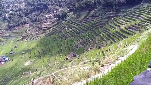
The Ifugao Rice field
The Banaue Rice Terraces (Filipino: Hagdan-hagdang Palayan ng Banawe) are terraces that were carved into the mountains of Banaue, Ifugao, in the Philippines, by the ancestors of the indigenous people. The terraces are occasionally called the "Eighth Wonder of the World".[1][2][3] It is commonly thought that the terraces were built with minimal equipment, largely by hand.[4] The terraces are located approximately 1,500 metres (4,900 feet) above sea level. These are fed by an ancient irrigation system from the rainforests above the terraces. It is said that if the steps were put end to end, it would encircle half of the globe.[5]
Locals up to this day still plant rice and vegetables on the terraces, although more and more younger Ifugaos do not find farming appealing,[6] often opting for the more lucrative hospitality industry generated by the terraces.[7] The result is the gradual erosion of the characteristic "steps", which require constant reconstruction and care. In 2010, a further problem encountered was drought, with the terraces drying up completely in March of that year.[8]
Anthropologist Otley Beyer has estimated that the terraces are over 2000 years old, but several researchers dispute this and contend that they were built much later.[9][10] There are also giant earthworms ("olang" in Ifugao) of the genus Pheretima or Polypheretima elongata which are blamed for causing damage to the terraces,[11] as well as rodents of the genus Chrotomis mindorensis, and snails.[12]
8
views
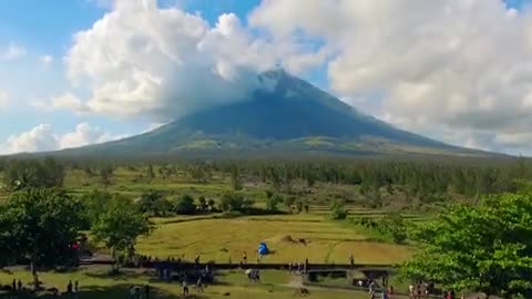
Majestic Mt. Mayon
Mayon (Central Bicolano: Bulkan Mayon; Tagalog: Bulkang Mayon, IPA: [mɐjɔn]), also known as Mount Mayon (Spanish: Monte Mayón),[4] is an active stratovolcano in the province of Albay in Bicol Region, on the island of Luzon in the Philippines. A popular tourist spot, it is renowned for its "perfect cone" because of its symmetric conical shape, and is regarded as sacred in Philippine mythology.[5]
The volcano with its surrounding landscape was declared a national park on July 20, 1938, the first in the nation. It was reclassified as a natural park and renamed the Mayon Volcano Natural Park in 2000.[6] It is the centerpiece of the Albay Biosphere Reserve, declared by UNESCO in 2016,[7] and is currently being nominated as a World Heritage Site.
Mayon is the most active volcano in the Philippines, and its activity is regularly monitored by PHIVOLCS from their provincial headquarters on Ligñon Hill, about 12 kilometers (7.5 mi) from the summit.[8]
14
views
Stunning Bohol
This video is all about the beautiful country that is the province of Bohol Philippines.
Adventures of a lifetime honors and pays reverence and tribute to this great province. We are staying true to our love for travel as main inspirations that led to the creation our channel that aims to explore and document life's wonders.
Bohol is a province of the Philippines, in the country’s Central Visayas region. It comprises Bohol Island and numerous smaller surrounding islands. Bohol is known for coral reefs and unusual geological formations, notably the Chocolate Hills. On the main island, near the town of Carmen, these 1,200 or so symmetrical mounds turn cocoa-brown in the dry season, contrasting with the surrounding jungle's greenery.
Boholanos still affectionately call their province the ‘Republic of Bohol’, in reference to the island’s short-lived independence at the turn of the 19th century. It's an appropriate appellation – today's successors of the republic are fierce protectors of Bohol's distinctive cultural heritage. The 7.2-magnitude 2013 earthquake killed more than 200 people and destroyed several of the island's majestic Spanish-era churches. Reconstruction is ongoing and is likely to continue for the next few years, but otherwise few obvious effects of the quake are visible.
19
views

The Island Bohol
Sometimes the best experiences in traveling are the unexpected finds. And so it is with Bohol, that island province that is nestled in the heart of Central Visayas and is aptly called "God's Little Paradise" by those who are caught off-guard by its mystery and charm.
Located southeast of Cebu and southwest of Leyte, Bohol is comprised of 47 towns and its capital, Tagbilaran City. Oval in shape like the proverbial ubing kinampay or purple yam, its total land area is 411,726 hectares including 73 other islands and islets.
Upon hearing about Bohol, most people would surmise it to be a typical uncolorful province with only the world-famous Chocolate Hills as its attraction. But the marvelous 1,001 nature-perfected conic hills aren't all there is. Blessed with Mother Nature's bounty, Bohol has numerous natural attractions that will captivate a person, hold him in breathless admiration and beckon him to keep coming back for more.
Bohol's beauty lies in its unpolluted waters and shorelines of white sand beaches. Lovers of scuba diving can explore the depths of Bohol's waters which are rated among the best diving havens in the world and famous not only for its richness in marine life and corals but also for its being the home of the world's rarest shells such as the Gloria Maris and the Golden Cowry.
Bohol is also the home of the tarsier, the big-eyed insect insect-eating primate whose size is smaller than one's fist. Scientists regard the tarsier as the oldest mammal now inhabiting the earth.
Other added attractions are waterfalls amidst verdant forests, caves with stalagmites and stalactites, natural parks, exotic wildlife, centuries old churches, and many historical landmarks. Delicacies too, which are truly Boholano like the sticky concoction in a coconut shell called calamay, mouth-watering peanut kisses, hojaldres, kinatloan and many more.
Bohol has a rich historical and cultural heritage. History tells us that the first international peace treaty, otherwise known as the "Blood Compact" between Sikatuna and Legazpi, was made on the island.
Boholanos are said to be valiant in character as accounted for by the Tamblot and Dagohoy rebellions. At the same time they are peaceful, self-reliant and deeply religious. But the peace-loving Boholanos are not docile, weak or submissive people when their rights are trampled or provoked.
Determined to go with the national trend towards progress, the province has now joined the bandwagon of urban and countryside development. Industries have sprouted along continuous improvement of infrastructure and other physical resources. Like her booming neighbor Cebu, Tagbilaran is already fast becoming highly commercialized with increased trading activities. And with the recent declaration of Panglao Island as the first tourism estate in the country, investors keep pouring in.
It's only a matter of time, given the necessary impetus for economic development, that progress for Bohol will finally be achieved. And this dream is not far behind considering the resiliency and industry of the Boholano people.
Come to Bohol and taste a different kind of experience as its surprises unfold to pleasure and thrill.
32
views
Travel Panglao Bohol
The island has an area of 91.12 square kilometres (35.18 sq mi). It is within Bohol Province, and comprises two municipalities: Dauis and Panglao. Panglao island is located southwest of the island of Bohol and east and south of Cebu.
Panglao has a terrain that ranges from plain, hilly to mountainous. Panglao is made of Maribojoc limestone, the youngest of the limestone units found in the western area of Bohol. The limestone composition delayed the development of the international airport as coralline limestone is soluble which causes formation of caves and sinkholes. One interesting geological feature found in the island is the Hinagdanan Cave which has an underground water source. The cave is an important water source as the island has no rivers or lakes.
Panglao is a popular tourist destination in the Philippines and includes several small islands, such as Gak-ang, Pontod, and Balicasag and is close to Pamalican island.
According to the 2015 census, it has a population of 79,216. [2]
16
views
Kawasan Falls Cebu
Kawasan Falls is one of the most popular waterfalls in Cebu and is located in Barangay Matutinao, Badian at the southwest part of the province. It is also just an hour away from Moalboal, which makes it an ideal nature side-trip after a day at the beach. Kawasan has two main waterfalls that are both deep enough for swimming. The first set of falls has a height of over 40 meters, while the second set has a wider area with a height of 20 meters. There is a small third falls a few kilometers away from the second one but is rarely frequented by tourists.
The water from the Kawasan Falls comes from the Kabukalan Spring and passes through the Matutinao River and Tanon Strait (Wikipedia
Article). The Kawasan Falls is managed by the local government, they work hand-in-hand with the locals to make sure that waterfalls is regularly maintained and well-preserved.
Visiting
The entrance fee to Kawasan Falls is only ₱40 ($0.88). The first waterfalls has a wider swimming area and deep catch basin. The refreshing cold water of the Kawasan Falls have been deemed therapeutic to some locals and elders. If you decided to take a dip in the pool, life jackets can be rented for ₱50 ($1.10) per person.
Bamboo rafts are available for only ₱300 ($6.60). These rafts can take you to the base of the waterfalls where one can have a relaxing “shower massage.” The pressure from the water is quite strong thus creating a soothing feeling to the back muscles. The raft can hold 15 to 20 people at a time.
Renting a cottage and a picnic table costs around ₱500 ($11), while tourists who want to stay over for the night can rent overnight cottages ranging from ₱800 ($18) to ₱2,000 ($44).
-
Kawasan Falls
19
views
1
comment
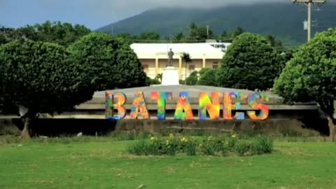
Travel Batanes
Batanes (Ivatan: Provinsiya nu Batanes; Tagalog: Lalawigan ng Batanes, IPA: [bɐˈtanes]) is an archipelagic province in the Philippines, administratively part of the Cagayan Valley region. It is the northernmost province in the country, and also the smallest, both in population and land area. Its capital is Basco located on the island of Batan.
The island group is located approximately 162 kilometres (101 mi) north of the Luzon mainland and about 190 kilometres (120 miles) south of Taiwan (Pingtung County), separated from the Babuyan Islands of Cagayan Province by the Balintang Channel, and from Taiwan by the Bashi Channel. The entire province is listed in the UNESCO tentative list for inscription in the World Heritage List. The government has been finalizing the site's inscription, establishing museums and conservation programs since 2001. The government aims to push for the site's inclusion between 2018 and 2019. Seven intangible heritage elements of the Ivatan have been set by the Philippine government in its initial inventory in 2012. The elements are undergoing a process to be included in the UNESCO Intangible Cultural Heritage Lists between 2018 and 2025.
6
views
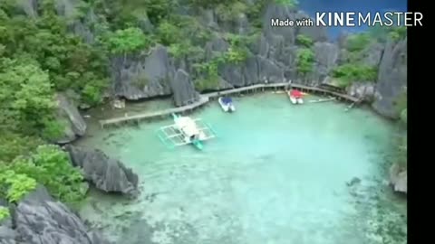
Travel Coron Philippines
Not to be confused with Koror, Palau.
This article is about the municipality. For the island, see Coron Island.
Coron
Municipality
Municipality of Coron
Coron skyline
Coron skyline
Flag of Coron
Flag
Map of Palawan with Coron highlighted
Map of Palawan with Coron highlighted
OpenStreetMap
Coron is located in PhilippinesCoronCoron
Location within the Philippines
Coordinates: 12°00′N 120°12′ECoordinates: 12°00′N 120°12′E
Country Philippines
Region Mimaropa
Province Palawan
District 1st district
Founded 1902
Barangays 23 (see Barangays)
Government [1]
• Type Sangguniang Bayan
• Mayor Mario T. Reyes Jr.
• Vice Mayor Asian A. Palanca
• Representative Franz Josef George E. Alvarez
• Electorate 32,894 voters (2019)
Area [2]
• Total 689.10 km2 (266.06 sq mi)
Elevation 8.0 m (26.2 ft)
Highest elevation 957 m (3,140 ft)
Lowest elevation 0 m (0 ft)
Population (2015 census) [3]
• Total 51,803
• Density 75/km2 (190/sq mi)
• Households 11,463
Economy
• Income class 1st municipal income class
• Poverty incidence 19.67% (2015)[4]
• Revenue ₱201,320,832.58 (2016)
Service provider
• Electricity Busuanga Island Electric Cooperative
Time zone UTC+8 (PST)
ZIP code
5316
PSGC
175309000
IDD : area code +63 (0)48
Climate type Tropical climate
Native languages Calamian Tagbanwa
Kagayanen
Palawano
Tagalog
Coron, officially the Municipality of Coron (Tagalog: Bayan ng Coron), is a 1st class municipality in the province of Palawan, Philippines. According to the 2015 census, it has a population of 51,803 people. [3]
The main population center of the municipality is composed of Poblacion barangays 1 to 6, where the Municipal Building, the Municipal Legislative Building, and the Judicial Hall of the Municipal Circuit Trial Court are located. Its fiesta is held annually on August 28 in honor of Saint Augustine. It is the commercial capital of the Calamian Islands.
The municipality is home to the Coron Island Natural Biotic Area, which is listed in the natural category of the UNESCO World Heritage Tentative List.[5]
Geography
The municipality of Busuanga comprises the western part of Busuanga Island, while Coron comprises the eastern part of Busuanga Island, all of Coron Island and about 50 other minor islets stretching as far as Tara Island in the north-east and Canipo Island in the south.[6] All these islands are part of the Calamian Archipelago in Northern Palawan that separates the South China Sea from the Sulu Sea.
16
views