
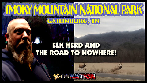
Great Smoky Mountains National Park: Gatlinburg, Tennessee
Great Smoky Mountains National Park is situated in the Appalachian Mountains, encompassing over 500,000 acres of land. It is one of the largest protected areas in the eastern United States.
The park is known for its stunning natural beauty, including lush forests, cascading waterfalls, mountain peaks, and diverse wildlife. It is also famous for the "smoky" mist or fog that often hangs over the mountains, giving the park its name. Great Smoky Mountains National Park is a biodiversity hotspot, home to an incredible variety of plants and animals. The park offers an extensive network of hiking trails, ranging from easy strolls to challenging backcountry treks. The Appalachian Trail passes through the park as well.
The Road to Nowhere, extends for about 6 miles, leading visitors to the Tunnel to Nowhere which is located in the southern Great Smoky Mountains National Park. It's known as the Road to Nowhere, and guides you to the Tunnel to Nowhere, refers to a tunnel that was never completed. The construction of Fontana Dam led to the flooding of several towns and the displacement of their residents. The road project was initiated to provide access to cemeteries and other ancestral lands of the displaced residents. The federal government, as part of a settlement, agreed to construct the road to allow access to these areas. A tunnel was carved through a mountain to connect the road to an area known as Forney Creek. However, funding for the road project dried up before the tunnel was completed. As a result, the road ends abruptly at the tunnel's entrance.
10
views

A Native Spirit's voice at Judaculla Rock: Cullowhee, North Carolina
Judaculla Rock is a large soapstone rock located in western North Carolina, near the town of Cullowhee. This rock is famous for its intricate petroglyphs. The carvings on Judaculla Rock are believed to be of Native American origin and have attracted the attention of archaeologists, historians, and enthusiasts interested in Native American history and art. It is estimated to be at least 3,000 years old. The rock is associated with the Cherokee people and their traditional
stories. In Cherokee lore, Judaculla (or Tsulkalu) is a mythical figure and a powerful being believed to have left his mark on the rock. The carvings are often interpreted as representing his actions or stories from Cherokee mythology. Recognizing its cultural and historical significance, Judaculla Rock is protected by the Eastern Band of Cherokee Indians and the Jackson County government. Visitors are encouraged to treat the site with respect and care.
While we were there, things appeared to be 'normal'. Upon our return home and during the video editing process, it was found that there was an extra voice in the footage. Check it out and see what you think it is!
15
views

US State Highpointing: Sunset on Sassafras Mountain, the highest point in South Carolina
Sassafras Mountain is the highest point in South Carolina. It's located in the Blue Ridge
Mountains of the south eastern United States. Sassafras Mountain reaches an elevation of
3,560 feet above sea level. It is situated on the border between South Carolina and North
Carolina, in Pickens County, South Carolina, and Transylvania County, North Carolina.
Sassafras Mountain features an observation tower that allows visitors to enjoy panoramic views of the surrounding landscape, including the beautiful Blue Ridge Mountains. From the top, four states can be seen. The Foothills Trail is a long-distance hiking trail that stretches for about 76 miles through the Upstate region of South Carolina, passes near Sassafras Mountain. We got there about 15 minutes before the sun was ready to drop. See what a sunset looks like from the top of South Carolina!
12
views

It's a Miricle! Spring of Faith: Epworth, Georgia
Tales of supernatural events and miraculous occurrences often carry cultural and historical significance. In many cultures, divine interventions, or mystical happenings are passed down through generations to explain certain phenomena or to emphasize moral lessons. In the case of the
Spring of Faith, a never-dry spring, formerly on a non-believer's property, mysteriously moved itself onto a neighboring church property in 1872, which christened it the Spring of Faith. Local legend has it that in the late 1800s, a spring was supernaturally moved during a rainstorm from a farmer's property onto church property after he put up a fence and forbade congregants to use it.
12
views

Chickamauga and Chattanooga National Military Park: Chattanooga, TN, & Fort Oglethorpe, GA
Chickamauga and Chattanooga National Military Park commemorates the Civil War battles that occurred in the area during 1863. The park encompasses multiple sites in and around the cities of Chattanooga, Tennessee, and Fort Oglethorpe, Georgia. It is situated in the Appalachian Plateau region and covers a significant area with diverse terrain, including forests, hills, and waterways. The Battle of Chickamauga took place from September 18 to 20, 1863, and the Battle of Chattanooga occurred later in November 1863. These battles were part of the larger struggle for control of the Tennessee River and Chattanooga, which was a key rail and transportation hub. The Union victory in the Battle of Chattanooga helped to secure the eastern portion of Tennessee and marked a turning point in the Civil War. The Battle was known as 'the death-knell of the Confederacy'. The park contains several cemeteries and numerous monuments and memorials dedicated to the soldiers who fought in the battles. The Chattanooga National Cemetery is one of the prominent burial grounds within the park.
Follow along this week to see what went down here!
22
views

Uncovering history of Russell Cave National Monument: Bridgeport, Alabama
Russell Cave National Monument is a historic and archaeological site located in northeastern Alabama, near the town of Bridgeport. It is managed by the National Park Service and is an important site for understanding the prehistoric Native American occupation of the southeastern United States. The cave is situated in Jackson County, Alabama, close to the border with Tennessee. It is nestled in a limestone rock shelter in the Cumberland Plateau region, which provides protection for the archaeological remains. The primary significance of this place lies in its archaeological deposits, which contain evidence of human habitation dating back thousands of years. The cave was occupied by prehistoric Native American cultures for over 10,000 years, making it one of the most important archaeological sites in the southeastern United States. The cave served as a shelter and a resource-rich location for these prehistoric
inhabitants. Archaeological excavations have revealed tools, artifacts, pottery, and other items that shed light on the lifeways and cultures of the people who lived there. Russell Cave National Monument has a visitor center where visitors can learn about the archaeological findings, the history of the cave, and the Native American cultures that once inhabited the area. Exhibits, films, and interpretive programs are available to provide insights into the site's significance.
4
views

Huge Sinkhole! Neversink Pit: Fackler, Alabama
Neversink Pit, also known as Neversink, is a famous and deep sinkhole located near the town of Fackler in northeastern Alabama, in the Appalachian Plateau region. It is one of the most popular and frequently visited sinkholes in the United States. It's well known for its unique geological features.
The views from the top of the hole are incredible but it's mainly used by spelunkers (cave divers). Neversink is approximately 40 feet in diameter and reaches a depth of about 162 feet from the surface to the water level. The sinkhole is filled with groundwater, creating a unique diving environment. The cave system below the sinkhole is extensive, with underwater passages and chambers that divers can explore.
Access to Neversink Pit is restricted, and it is strongly recommended that only experienced cave divers with the proper training and equipment attempt to dive in the sinkhole. The sinkhole and its surrounding area may be on private property, so permission from landowners or authorities may be required for entry.
13
views

Unreal views at Weathington Park: Section, AL
Cruising through the Little River Canyon north, we didn’t expect to find one of Alabama’s best-kept secrets: Weathington Park. At 1,300 feet, the park is located in the foothills of the Appalachian Mountains. With a panoramic
view of the Tennessee River Valley below, Weathington Park is a must-see detour when riding through northern Alabama. The sunsets over the Tennessee River makes this an unbelievable spot for watching a sunset!
6
views

Cherokee Rock Village: Leesburg, Alabama
Cherokee Rock Village, AKA Little Rock City, is a unique natural rock formation and recreational area located in northeastern Alabama. The area was home to Native Americans almost continuously from 8000 BC until 1838, when the resident Cherokee and Creek Indians were forcibly removed by the Indian Removal Act and the resulting Trail of Tears. The site was of religious and ceremonial importance to these Native American groups. It's a very popular destination for hikers, rock climbers, andnature lovers for it's large sandstone boulders and rock outcroppings. Cherokee Rock Village has several scenic overlooks that offer breathtaking views of Weiss Lake and
the surrounding landscape. It's a literal playground for rock climbers and bouldering. Cherokee Rock Village is also home to many species of birds and small mammals. It's a great place for birdwatching, especially if you like to see Scarlet Tanagers, Summer Tanagers, and Great Crested Flycatchers . The site has designated picnic areas, making it a sweet place for an outing amidst the natural beauty of the area. Take a quick video tour with us this week to see how cool this place is!
10
views

Haunted Chicken House: Heflin, Alabama
The "Haunted Chicken House" in Alabama is a well-known haunted attraction that operates during the Halloween season. It is not an actual haunted house but rather a haunted attraction designed to provide visitors with a spooky and thrilling experience during the Halloween season and is known for the elaborate decorations, special effects, and actors in costumes who aim to scare and entertain guests.
At the roadside there are hearses, half-buried, with metal chickens welded to them. This unique display serves as advertising for the seasonal haunted house attraction, blending dark humor and creativity. A must see if cruisin' the back roads through Alabama!
12
views

US State Highpointing: Cheaha Mountain, highest point in Alabama
Cheaha Mountain, often simply referred to as Mount Cheaha, and at an elevation of 2,413 feet,
it is the highest natural point in the state of Alabama. Located in the northeastern part of the state within Cheaha State Park, it's part of the Talladega National Forest. The state park is also one of the oldest parks in Alabama. The mountain is known for its panoramic views and several scenic overlooks that provide awesome views of the surrounding woodlands and valleys. The most famous of these overlooks is Cheaha Bald, which is accessible by road and offers a stunning perspective of the region. This dramatic landscape gets its name from the Creek Indian name for the mountain, “chaha” meaning “high place”. We had a clear day and wicked views from the tower. Come along and climb the tower to see what those views are like on top of Alabama!
10
views

Elvis Presley Birthplace & Museum: Tupelo, Mississippi
Elvis Presley's birthplace is a well-known historical site located in Tupelo, Mississippi. It's a significant landmark for Elvis Presley fans and those interested in the history of the legendary musician. The birthplace is situated at 306 Elvis Presley Drive, Tupelo, Mississippi. The main attraction at 'The Kings' birthplace is the small, white, shotgun-style house where he was born on January 8, 1935. This modest home is preserved as it appeared during Elvis' early years and provides visitors with insight into his humble beginnings. Adjacent to the birth home, there is an Elvis Presley Museum. The museum features memorabilia, artifacts, photographs, and exhibits related to Elvis's life and career, from his childhood in Tupelo to his rise to fame as the King of Rock 'n' Roll. Near the birthplace and museum, you can find a statue of Elvis at 13 years old, representing his youthful days in Tupelo. The birthplace is a focal point for Elvis-related events and celebrations, particularly around Elvis's birthday in January and during the Tupelo Elvis Festival, which typically takes place in June. Tupelo holds historical significance in Elvis Presley's life, as it was where he spent his early years and developed an interest in music. The church he attended as a child, the Assembly of God Church, is also located nearby and can be visited. Efforts have been made to preserve the birthplace and its associated structures to ensure that future generations can learn about Elvis's formative years and the impact he had on the music industry.
26
views

Brices Cross Roads National Battlefield: Tupelo, Mississippi
On June 10, 1864, during the Civil War, Union forces under the command of Major General William T. Sherman were advancing through the South with the goal of capturing Atlanta, Georgia. Confederate General Nathan Bedford Forrest was tasked with disrupting Sherman's supply lines and preventing Union forces from moving freely through Mississippi and
Tennessee. General Forrest, a skilled and daring cavalry commander, planned to engage and defeat Union forces in Mississippi to slow Sherman's advance.
The Battle of Brice's Crossroads popped off when Forrest's Confederate cavalry fought with Sturgis's Union forces. The battle was fought in intense heat during several hours of brutal combat. Despite being outnumbered, Forrest's cavalry outmaneuvered and beat Sturgis's larger force. The Battle of Brice's Crossroads was an impressive Confederate win and is often cited as an example of Forrest's tactical genius. Sturgis's Union forces suffered heavy casualties and were forced to retreat.
13
views
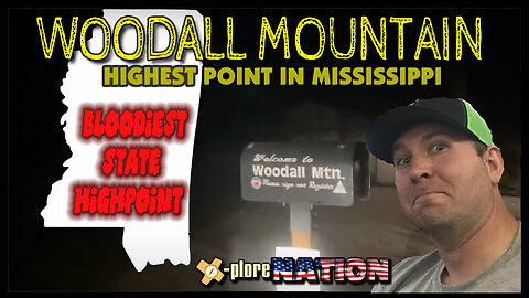
US State Highpointing: Woodall Mountain, highest point in Mississippi
Woodall Mountain is located in Tishomingo County (named after a prominent Chickasaw leader) in northeastern Mississippi, near the town of Iuka. It's part of the Appalachian Plateau region and is situated within the Appalachian Mountains. Woodall has an elevation of 807 feet above sea level, making it the highest point in Mississippi. It also offers insane views for those who do it in daylight hours. But Woodall Mountain isn’t just famous for its awesome views. It’s also known as the bloodiest U.S. state high point. Back in 1862, Union and Confederate soldiers of the Civil War fought for control of the hill in the “Battle of Iuka.” Back then, Woodall Mountain was known as Yow Mountain. Tag along for a night cruise up to the top of Mississippi!
28
views

Shiloh National Military Park: Shiloh, Tennessee
Shiloh National Military Park was established on December 27, 1894, to preserve
and commemorate the battlefield and its historical significance. It was one of the earliest national military parks in the United States. Shiloh offers self-guided and ranger-led tours of the battlefield. There are marked trails and interpretive signs that guide you through key areas of the battlefield, including the Hornet's Nest, the Peach Orchard, and Shiloh Church.
Throughout the park, you can find numerous monuments and memorials erected by US States and organizations to honor the soldiers who fought in the Battle of Shiloh. The park also includes the Shiloh National Cemetery, where many Union and Confederate graves are.
Many feel a heavy paranormal presence while visiting Shiloh. There have been reports of ghostly horses and riders on the battlefield, reminiscent of the cavalry that rode in the Battle. Full bodied apparitions are often seen near monuments and near the cemetery.
We didn't make it before the sun set so we took an unplanned night tour of this incredible place. Come along and see for yourself!
32
views

Meriwether Lewis National Monument: Hohenwald, Tennessee
This park is known as the "Meriwether Lewis National Monument" or simply "Meriwether Lewis Park." It's named for Meriwether Lewis, one of the leaders of the Lewis and Clark Expedition (1804-1806). Meriwether Lewis was an American explorer, soldier, and public administrator. He is most famous for his role as the leader of the Lewis and Clark Expedition, which was commissioned by President Thomas Jefferson to explore the newly acquired western territory of the United States, often referred to as the Louisiana Purchase. The Meriwether Lewis National Monument is located near Hohenwald, Tennessee. It commemorates the life and achievements of Meriwether Lewis. The park includes a memorial building and a gravesite. Meriwether Lewis died under mysterious circumstances in 1809 while traveling along the Natchez Trace in Tennessee. His death has been the subject of speculation and debate, with some suggesting that it may have been a murder rather than a suicide, as originally believed.
11
views
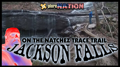
Hiking to Jackson Falls on the Natchez Trace: Duck River, Tennessee
Jackson Falls is a popular natural area located in Tennessee, specifically in the Duck River watershed. It is known for its beautiful waterfalls, lush greenery, and hiking opportunities. The falls are situated within the state's Highland Rim region, which is characterized by rolling hills and scenic landscapes. The trail, a 900-foot-long concrete sidewalk, provides visitors with access to the base of Jackson Falls. The falls are beautifully sculptured creating an aesthetically pleasing cascade. The clear pool at the base of the falls provide a serene and picturesque setting.
Starting from the same parking area, we were also able to visit Baker Bluff Overlook which offers one of the best scenic views along the entire Natchez Trace Parkway. It's a short 3/4-mile hike to the overlook.
4
views

The Stones River National Battlefield: Murfreesboro, Tennessee
The Battle of Stones River, also known as the Battle of Murfreesboro, took place from December 31, 1862, to January 2, 1863, during the American Civil War. It had the highest percentage of casualties on both sides. The Union victory at Stones River had significant implications for the war and had a lasting impact on both sides. The battlefield covers approximately 700 acres and commemorates one of the major battles that took place during the war. The park features various stops and monuments that mark key locations and events during the Battle of Stones River. These include Hazen Brigade Monument, McFadden Farm, and the Confederate Cemetery, among others. It was one of the bloodiest battles and had a major impact on the course of the war.
Come along this week to see what the battlefield and has to offer!
5
views

Sellars Indian Mound: Seeking the Tennessee Wildman! in Lebanon, Tennessee
Sellars Farm State Archaeological Area, AKA Sellars Indian Mound, is an important archaeological site located in Wilson County, Tennessee. It is one of the most significant prehistoric mound complexes in Tennessee and the surrounding region. Sellars Farm near Lebanon, Tennessee is a large prehistoric mound complex that includes several earthen mounds. The mounds at Sellars Farm were constructed by indigenous peoples during the Middle Woodland period, which is from around 100 BCE to 500 CE. This period saw the development of complex societies in the eastern United States. The mound complex at Sellars Farm is associated with the Mississippian culture, a prehistoric Native American culture known for its mound-building and complex societies. The site is believed to have been a ceremonial and religious center. Archaeological excavations at Sellars Farm have provided valuable insights into the culture, architecture, and social organization of the people who inhabited the site during the Middle Woodland period. The site is open to the public, and we were able to explore the mounds and learn about the archaeological significance of the area.
Before we arrived at the site, an important news clip came across the radio in regard to the Tennessee Wildman. Follow along on this week's episode to find out what went down!
(Tennessee Wildman: A cryptid described as a large, ape-like creature resembling Bigfoot or Sasquatch. Sightings and reports of the Tennessee Wildman have been documented in various parts of the state, particularly in remote and wooded areas. Locals describe it as a tall, hairy, and elusive creature.)
20
views

The Obed Wild and Scenic River (NPS): Wartburg, Tennessee
The Obed River and its tributaries flow through the Cumberland Plateau in eastern Tennessee.
It's a popular destination for outdoor activities such as whitewater paddling, kayaking,
and rafting. The river features Class III to Class IV rapids, making it a favorite among experienced paddlers. The Obed area is also renowned for its rock-climbing opportunities. Sandstone cliffs and rock formations provide a variety of climbing routes for both beginners and experienced climbers.
The park offers several hiking trails that provide access to scenic viewpoints, waterfalls, and the river itself. The Obed Wild and Scenic River area contains a rich cultural and natural history. There are remnants of old settlements, historic sites, and opportunities to learn about the area's geological features. The park is home to a variety of wildlife, including deer, turkey, and various bird species.
We drove to the area of Clear Creek and Jett Bridge to see if anyone was running the river today. This section of river is the most popular run in the park. The snow blanketed the area and Clear Creek was a peaceful spot to chill. Come along for a sample of what the Obed Wild and Scenic River have to offer!
4
views

Big South Fork National River: Wampus Cat Sighting? Oneida, TN
The Big South Fork National River and Recreation Area is a vast and diverse natural area situated on the Cumberland Plateau, covering 125,000 acres. Its primary purpose is to preserve the free-flowing Big South Fork of the Cumberland River along with its tributaries. The region spans across multiple counties, including Scott, Fentress, Pickett, and Morgan counties in Tennessee, as well as McCreary County in Kentucky.
In Southeast Tennessee, there's a cryptid called a Catty-Wampus, but most know it as the Wampus Cat. The Wampus cat allegedly has several supernatural abilities, one of the most notable being its ability to emit spine-chilling screams. The half-cat creature is also thought to possess exceptional speed, agility and stealth, allowing it to navigate the densest of forests and remain undetected. Legends suggest that it can shape-shift or become invisible, making it even more challenging to track or capture. These extraordinary abilities have both fascinated and frightened those who have delved into the beast's mythology.
We had our own encounter that we could not explain. Take a look for yourself and see if this is indeed, the infamous Wampus Cat!
12
views

Driving under Cumberland Gap National Historic Park, Middlesboro, KY
The Cumberland Gap Tunnel is a dual-bore, four lane vehicular tunnel that carries U.S. Route 25E under Cumberland Gap National Historical Park near the intersection of Kentucky, Tennessee, and Virginia.
So, on our way through the tunnel, we tried to make our way to the National Historic Park. It was snowing and the GPS proclaimed, 'You have arrived' as we went back and forth through the tunnel. Needless to say, we were in the tunnel and went under the park. Does this even count? :P This was a fun clip from the trip but looks like we have to come back for part two of the National Historic Park! To be continued...
Danger Snow - Dan Henig
6
views

US State Highpointing: Black Mountain, highest point in Kentucky
Black Mountain is the highest point in Kentucky, with an elevation of 4,145 feet. It is situated in Harlan County, Kentucky, near the border with Virginia in the Appalachian Mountains. The region around Black Mountain has a long history of coal mining. The mountain itself contains rich coal deposits, and coal mining has been a significant economic activity in the area for many years. The environmental impact of coal mining on Black Mountain and its surrounding areas has been a subject of concern for some. Mountaintop removal mining has been used in the region. Efforts have been made to balance economic development through mining with the preservation of the natural environment around Black Mountain. Conservation groups and government agencies have been involved in initiatives to protect the mountain and its ecosystems. The area's natural beauty and outdoor activities attract tourists and outdoor enthusiasts who come to explore the Appalachian wilderness. It's well known for outdoor recreational activities including ATV and dirt bike riding, as well as hiking and camping.
When we went to climb the mountain, there was still a permit system in place. This is no longer the case. The state now owns the summit and does not require a waiver to climb to the peak.
Music from #Uppbeat (free for Creators!):
https://uppbeat.io/t/vens-adams/easy-morning
License code: 8H4MSK7Z7NOWKJWR
7
views
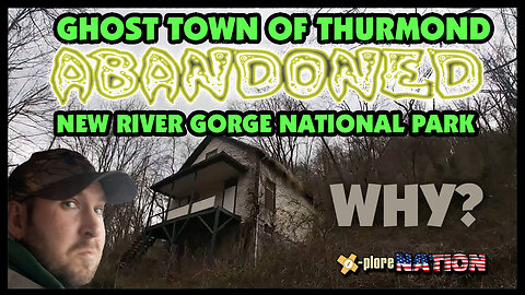
New River Gorge National Park: A huge bridge, a ghost town, and Gauley/Bluestone Rivers, Lansing, WV
In 2020, the New River Gorge was designated as a national park and preserve, becoming America's newest national park. The New River Gorge is a prominent natural and recreational area located in the Appalachian Mountains of southern West Virginia. The gorge is known for its steep cliffs, lush forests, and the rugged terrain of the Appalachian Plateau. Despite its name, the New River is considered one of the oldest rivers on earth, with a geological age of around 320 million years. It flows northward, making it one of the few major rivers in the US that flows in this direction.
The New River Gorge is a popular destination for outdoor enthusiasts. It offers a wide range of recreational activities, including whitewater rafting, rock climbing, hiking, mountain biking, and fishing. The area is particularly renowned for its world-class whitewater rapids.
One of the most iconic features of the area is the New River Gorge Bridge. It is one of the longest single-span arch bridges in the world and spans the canyon at a height of 876 feet. The bridge is not only a vital transportation route but also a popular spot for BASE jumping and a major symbol of West Virginia.
Part of the New River Gorge NP is the ghost town of Thurmond. During its boomtime, it had two hotels and two banks. The downtown area had restaurants, clothing stores, a jewelry store, and dry-goods stores. The town even had a movie theater. There were many business offices for the telephone company, lawyers, and more. The town continued to thrive through the early decades of the 20th century.
We awoke in the Gauley River National Recreation Area and drove to the canyon rim where we took in the dizzying heights of the bridge at the National Park. Shortly after we made our way up to one of the coolest ghost towns in America, Thurmond. It's an abandoned traveler's dream, we poked around the old buildings and after we had our fill, moved along to Bluestone National Scenic River to finish the day.
Edgen - Traveling the Lands
Music from #Uppbeat (free for Creators!):
https://uppbeat.io/t/bosnow/sea-cruise
License code: XKAQAZSOZRYFSBSP
Music from #Uppbeat (free for Creators!):
https://uppbeat.io/t/danijel-zambo/friendly-ghost
License code: 9WFT4WLFWCSWDKYO
Edgen - The Marble Staircase
Music from #Uppbeat (free for Creators!):
https://uppbeat.io/t/vens-adams/breath-of-nature
License code: BGOTY14B1OTJR0JC
9
views

Mummies of Philippi and the Trans-Allegheny Lunatic Asylum: Weston, West Virginia
Graham Hamrick developed an embalming technique in the late 1800s and used bodies from a nearby insane asylum to practice and refine his methods. He experimented with his embalming fluids on fruits and vegetables before applying them to human bodies successfully.
The embalmed bodies, often referred to as the "insane mummies," were said to have traveled with P.T. Barnum and his circus, which added an element of showmanship to their history. The Smithsonian Institution expressed interest in displaying Hamrick's work but was refused access to the embalming formula, leading to the mummies being returned to Philippi.
Today, these mummies are on display in a small room at the historical society, having been restored and preserved to some extent. Just down the road, the Trans-Allegheny Lunatic Asylum, also known as the Weston State Hospital, is a historic mental institution located in Weston, West Virginia, USA. The asylum was completed in 1864. It was initially built to accommodate 250 patients but later became overcrowded, housing over 2,400 patients at its peak in the 1950s. It is one of the largest hand-cut stone masonry buildings in the United States. Like many institutions of its time, the asylum used various treatments for mental illnesses that are considered inhumane by today's standards. These included electroshock therapy and lobotomies. As the field of psychiatry evolved, the asylum's practices changed accordingly. Today, the Trans-Allegheny Lunatic Asylum offers guided tours that allow visitors to explore its historic architecture and learn about the history of mental health treatment in the United States. It has become a popular tourist attraction and a place for paranormal enthusiasts, as it is rumored to be haunted. The asylum has gained a reputation as a hotspot for paranormal activity. Some visitors claim to have experienced ghostly encounters and strange occurrences during their tours.
21
views